Deployment of an innovative multi-sensor system for monitoring in a complementary manner ground deformation and seismic motion in subsidence-prone urban areas.
![]()
Status: DEMONSTRATOR
INDES MUSA (www.indes-musa.gr)
Innovation
Integrated monitoring solutions constitute a prerequisite towards risk mitigation and urban planning policies against soil subsidence and seismic motion, providing valuable knowledge and data for investigating the corresponding physical mechanisms.
The above concept lies between the main framework of actions of INDES-MUSA project aiming at the deployment of an innovative multi-sensor system for monitoring in a complementary manner ground deformation and seismic motion in subsidence-prone urban areas.
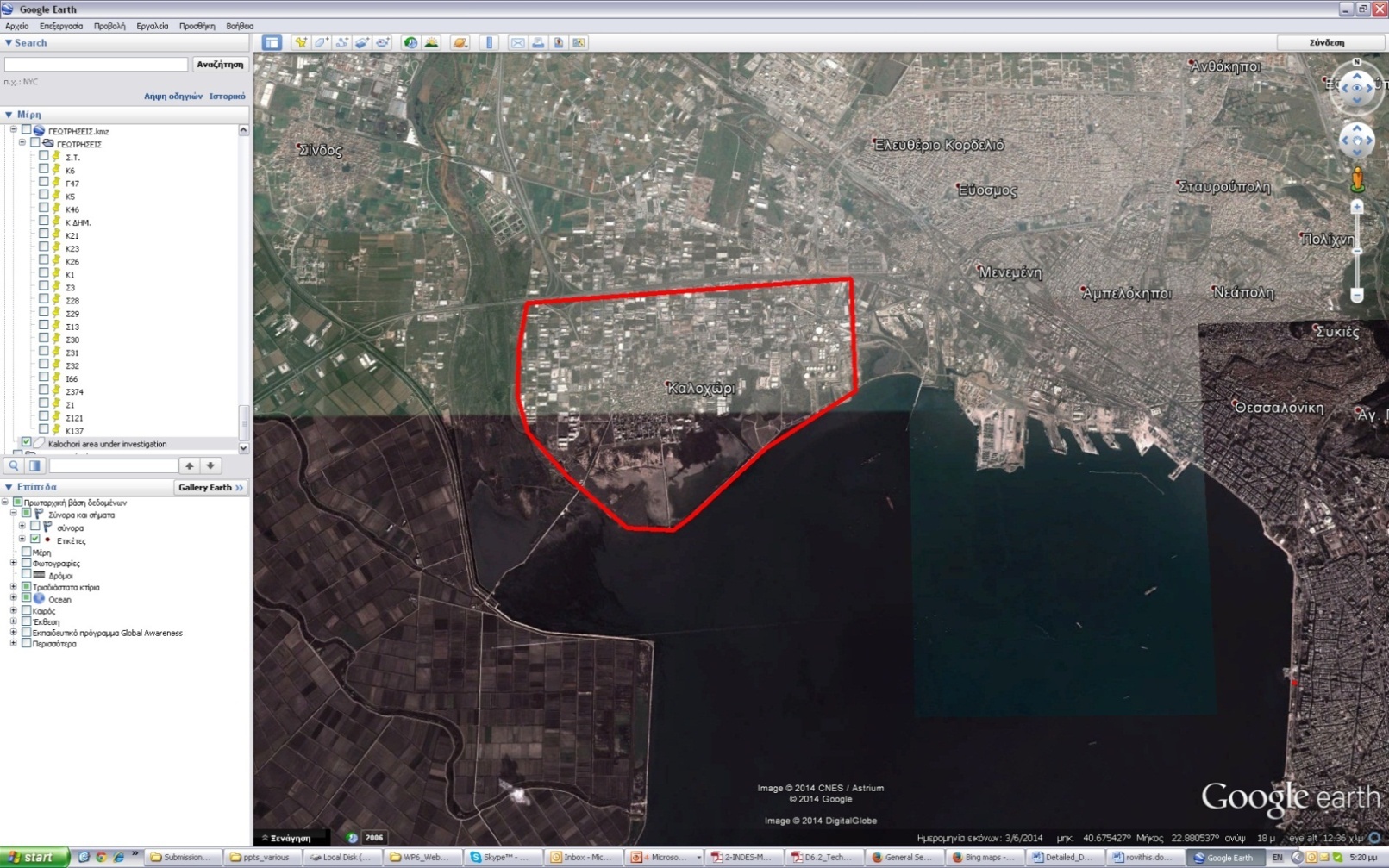
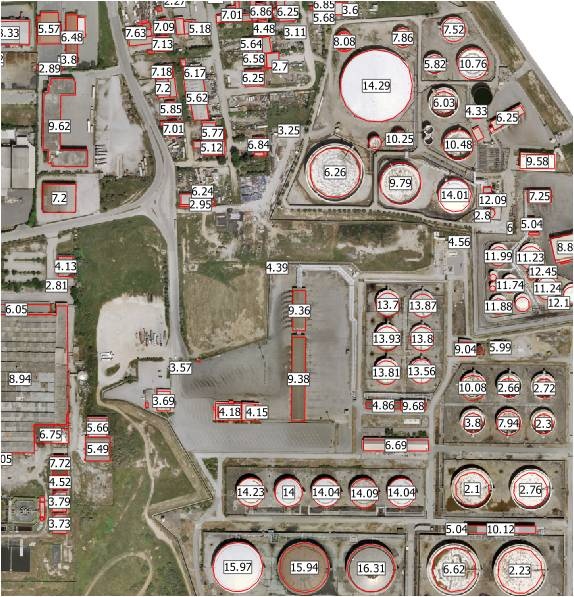
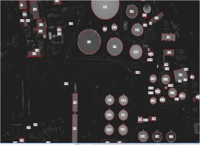
Study Area, Kalochori
Impact
Multi-sensor scheme
The combination of the project actions within the overall objectives of the project is expected to result in a well-documented and innovative Web-based pilot study for monitoring urban subsidence and seismic response in the selected sites towards an integrated product to end users for both urban hazard assessment studies and future development strategies in the context of an economic and risk mitigation benefit for the society. In this regard, the proposed advancement of a multi-sensor monitoring of natural hazards examined within the INDES-MUSA project, in conjunction to validated scientific results integrated in a Web-GIS platform, will provide a flexible template for future development of both institutional and commercial services with applicability over a broad range of potential market sectors in urban areas with similar risk mitigation needs. Additionally, the project is expected to have a direct benefit to the participating enterprises and research teams based on a profitable technical know-how or/and scientific personnel exchange between the two countries.
Concept
Integration
The main goal of the project is the establishment of integrated tools and models for large-scale multi-risk assessment in urbanized environments prone to ground subsidence and seismic action by means of innovative, multi-sensor and cost effective monitoring schemes. Risk and vulnerability of urban areas to the above natural hazards constitute an inherently spatial problem leading by definition to an emerging need for corresponding urban-scale and highly-accurate monitoring solutions that can be used by end users and decision-making policies for risk management, disaster preparedness, environmental resource management and urban planning in the future. The above concept becomes particularly valuable in the case of complex urban landscapes containing physically different typologies of residential structures, critical facilities and civil infrastructures. In this context, the INDES-MUSA project aims at providing readily available monitoring data in the form of spatial distribution models related to ground subsidence and seismic motion through a web GIS platform applied in properly selected urban sites in Greece and China respectively.
Technical details
The Greek site under investigation is located in the region of Kalochori close to Thessaloniki port in North Greece, presenting great scientific and monitoring interest related to the examined natural hazards, thereby in agreement with the general objectives of the project.
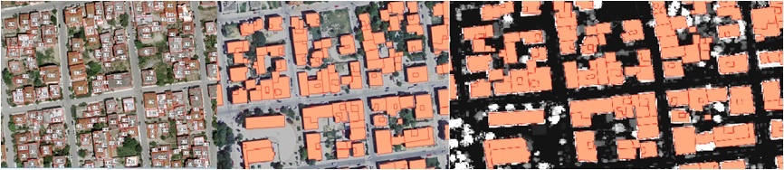
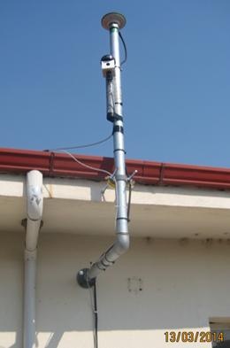
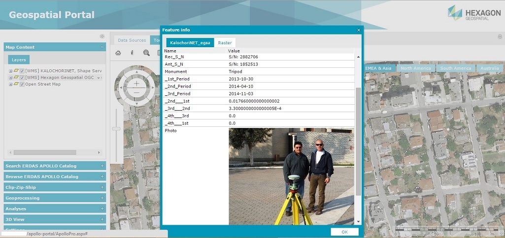
The integrated nature of the monitoring scheme is provided by a combination of two Airborne Lidar Leica ALS60 missions for change detection purposes and production of an accurate 3D city model combined with the town planning data of the constructions in the urban, industrial, gas and oil tanks area next to the port, Airborne DMC frame camera RGBNIR data at 0.10 cm ortho production, mobile GNSS stations, a tide gauge and water level sensors for ground subsidence measurements complemented by permanent seven accelerographic and two GNSS stations for monitoring seismic motion. The above multi-sensor scheme is deployed as an innovative pilot study, based on available means, in properly selected urban site. Besides monitoring and data processing, soil subsidence and seismic motion are being investigated by means of pertinent methods of analysis that will be developed and adapted in an urban-scale sense aiming at a better understanding of the investigated hazard sources as affected by the urban environment. Both recorded data and analysis predictions are integrated, combined and implemented towards the development of a research tool and they are made readily-available and accessible to the scientific community and local/national decision-making authorities through a properly designed Web GIS platform.
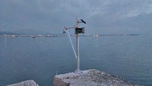
GNSS & Tide Gauge
Contact info
Name: Betty Charalampopoulou
Email: mail@geosystems-hellas.gr
Address: Gkinosati, Metamorfosi, Greece. Tel: +30 21 0281 5481
Participants in the project: GEOSYSTEMS HELLAS S.A. (coordinator) and the research institutes: EPPO-ITSAK, NOAIG.
More about Geosystems Helas S.A.:
- GEOSYSTEMS HELLAS S.A. [GSH] was established in Athens in November 2009 as the newest member of GEOSYSTEMS EU GROUP Member (www.geosystems-group.eu) acting commercially as Hexagon Geospatial solutions authorized reseller and as a consultant in Greece and Cyprus. Working on subjects of commercial Photogrammetrical and RS projects and R&D projects for land management, [GSH] is deeply involved in Big Data and Data Fusion for automatic classification for National projects in Greece. On subjects of Geodetic and Environmental Monitoring is working closely with METRICA S.A. (GSH shareholder, www.metrica.gr, www.metricanet.gr), taking advantage of the GNSS Reference Network -SmartNet Greece- that METRICA S.A. has established, and its expertise. The success of the company is based on the qualified staff of engineers with experience of at least 20 years working in the same market. [GSH] holds significant background in image exploitation, processing, visualization and geospatial data management in order to meet a broader spectrum of customer needs in today’s enterprise environment.
- The mission: “To help organizations harness the information of the changing earth for greater advantage, by creating geospatial business systems that transform our earth’s data into business information” following the founders motto “Two thousand years before, the Greek Mathematician Aristarhos from Samos stated that the earth is moving around the Sun following a circular trajectory… “
- [GSH] is a funded member of si-cluster (the Unique Hellenic Space Cluster), www.si-cluster.gr/en and The Hellenic Association of Space Industry (HASI), www.hellenic-asi.org, focusing in the capabilities and competences of the company in the Greek industry in relation to its involvement in the space sector. [GSH] is mentioned in the European Space Agency - ESA Greek Space Capabilities - Catalogue by Bertin Technologies, 2014.
This page has no comments.