Success Story on the use of EO to monitor the impact of infrastructure (road) development on the habitat.
The Egnatia motorway axis is part of the Trans-European transport network (TEN) and one of the largest infrastructure projects in Europe. With a total length of 680 km it crosses the northern part of Greece and connects the Port of Igoumenitsa, Greece's entry point from Western Europe (via ferries from Italy), with the Town of Kipi at the Turkish border. The Egnatia Motorway was one of the first large-scale public works in Greece to apply a system of environmental management, i.e. a method of organising and implementing environmental protection measures in the design, construction, and operation of all stages of the project. The European Investment Bank (EIB) has supported the development of the Egnatia Motorway by provision of loans for a total of EUR 1.6 Billion Euro, a little more than a quarter of the total investment.
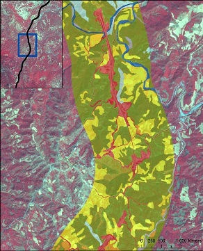
GeoVille produced geospatial information products from Earth Observation data regarding land cover and land cover change with a focus on the development a very high resolution base map and an update of the existing CLC2000 land cover information used by the Egantia Observatory. The service provided information compatible with pre-existing data and indicators to assess the environmental impact of the project as well as new, improved information for the creation of a new baseline and a more precise analysis of future changes.
ESA, as part of its Earth Observation Market Development (EOMD) program, has been interacting with the European Investment Bank (EIB) and their stakeholders to understand their working environment and information requirements in particular for EO services. This process has resulted in service specifications which have been put out for tender. The main purpose of this procurement, called "Exploitation of Earth Observations services in support of Environment Impact Assessment (EIA) within the Investment Banking and Steel industry" is to demonstrate and validate the utility of currently available EO information services in support of selected EIB projects. The EIB finances projects that help directly improve the environment, promoting not only EU environmental policy in general, but in particular the Sixth Environmental Action Programme.GeoVille was awarded a contract for service trial #2 "Habitat monitoring in the Egnatia motorway project", aiming at the collection and procurement of relevant input data (e.g. EO and ancillary data), processing this data to provide basic information for monitoring the progress of the construction work and its environmental impact.
The Egnatia Motorway runs through Greek mountainous and plain landscapes of exquisite beauty and ecological importance. Its alignment follows the Ancient Roman Via Egnatia. Along this ancient route, within an approximately 1 km wide zone, 270 sites of historical interest have been identified, while in its further vicinity, significant archaeological sites and natural resources of critical importance are located.
The successive natural and man-made environments along the project are exceptionally diverse, both through the mountains of Pindos and Western Macedonia, and the plains of Central / Eastern Macedonia and Thrace.
Along the route of the highway one can find:
17 Natural Habitat Areas protected under the European "Natura 2000" Network
4 Wetlands protected under the Ramsar Convention
70 wildlife conservation areas and
270 sites and monuments of historical interest
The final stage of construction (started in spring 2005) concerned the about 37km long section of the West Egnatia Motorway from Panagia to Grevena, running through one of the most picturesque forests of Pindos. In co-operation with various environmental organizations (Arktouros http://www.arcturos.gr/en/, etc.) and with the contribution of foreign experts, the promoter has decided to realize a road alignment that is particularly "environment-friendly", comprising twin bore tunnels, approximately 10.5 km long and large twin deck bridges, more than 1.5 km long, in order to meet all the environmental demands, as well as to reduce the impacts on the brown bear habitat.
A special observatory was designed to monitor and to assess the effects of the motorway on the local ecology during both construction and operation phases of the project (http://observatory.egnatia.gr/index_en.htm).
Objective of this Earth Observation demonstration project was to provide the EIB with
up-to-date information on the situation regarding the progress of the construction works,
a time series of the fragmentation of sensitive areas - focused on the habitat of large mammals like the brown bear - at the time before construction works started (before 2005), during the construction phase (2008) and after finalization of the road. The latter was to be simulated based on the road planning data.
Earth Observation (EO) imagery is the only information source that provides the opportunity to perform synoptic and periodic progress monitoring of large construction projects. The use of EO data for monitoring purposes reduces the need for on-site field visits to cases in which some anomalies are detected in the EO data.
EO provides an unrivalled contribution to a fast and cost-efficient monitoring strategy.
Return on investment
In 2009 alone the EIB approved more than 100.000 projects for funding: 90% in EU Member States and 10% in partner countries. For each project the EIB carries out a project monitoring across all project phases from the signature via the implementation until the loan is paid back. In particular, the Bank checks that the funds are being used in line with the objectives.
Project progress is normally reported by the promoter and independently verified by external reviewers on site. EO based progress monitoring offers an efficient way for reducing on site work by obtaining objective and unbiased information about the local situation which can be combined – when necessary – with in-situ observations in those cases where anomalies are detected.
EO based monitoring helps the EIB to more efficiently monitor and verify one of its central concerns: the protection and improvement of the environment as one of its own internal procedures: the environmental acceptability criteria of projects funded by the Bank include legal compliance, screening and quality of the environmental impact assessment, environment related risks, environmental capacity of the promoter, environmental impact and mitigation measures to be implemented.
About EIB – Luxembourg
The mission of the European Investment Bank is to further the objectives of the European Union by making long-term finance available for sound investment. The EIB was created by the Treaty of Rome with the Member States as its shareholders. Within the EU the EIB has 6 priority objectives for its lending activity which are set out in the Bank's business plan, the Operational Strategy (OS). This rolling plan spans three years, with the strategic projections adapted annually to take account of new mandates and changes in the economic climate.
In 2009, the European Investment Bank lent 79.1 billion Euro in support of the objectives of the European Union: 70.5 billion in the Member States of the Union and EFTA, and 8.6 billion in the partner countries.
More on EIV: www.eib.org
About ESA / ESRIN – Italy
ESRIN, known as the ESA Centre for Earth Observation, is one of the five ESA specialised centres situated in Europe. Located in Frascati, a small town 20 km south of Rome in Italy, ESRIN was established in 1966 and first began acquiring data from environmental satellites in the 1970s. Since 2004, ESRIN has been the headquarters for ESA's Earth Observation activities.
ESRIN acts as an interface between ESA and those who use its services. The centre has close links with European industry, the European Union and the civil protection, agriculture and environment ministries within ESA Member States. ESRIN also cooperates with international organisations including UN agencies and the European Commission, and plays an important role in many international projects.
More on the ESA programme Value Adding Element: http://www.eomd.esa.int/index.asp
About GeoVille Group
GeoVille Group is an internationally operating company providing consultancy, services and products related to remote sensing, geo-information and geographic information systems. Our environmental services provide the bridge from technical know-how - merging geospatial explicit data with statistics - to the analysis of what on-going processes and trends mean for the environment. GeoVille Group is dedicated to customer satisfaction and delivering quality controlled geo-information products and has successfully carried out projects in over 60 countries.
GeoVille Information Systems GmbH and GeoVille Environmental Services Sàrl are based in Austria and Luxemburg.
More on GeoVille: www.geoville.com
This page has no comments.