The Case Study of forest management in Sweden has been published in January 2016. This report is the last of a series of three cases in the frame of the study “Assessing the detailed economic benefits derived from Copernicus Earth Observation (EO) data within selected value chains”, undertaken by EARSC under an assignment from the European Space Agency (ESA).
Edit Sweden is a country dominated by forests. It contains just below 1% of the world’s commercial forest area, but provides 10% of the world´s sawn timber. Forest covers roughly 70% of Sweden, extending over 28 million hectares (ha). Of this area almost 23 million ha are productive forest land. Forest products generate an export value of €12 Billion and gives employment to about 90,000 people. Every year the forestland of Sweden produces a total of around 121 million m3 of wood. Around 50% of Swedish forests are owned by over 300,000 individuals or families; the other half by the government and industry. The current Swedish forestry Act, which took effect in 1994, has two main goals: one for production and one for safeguarding biodiversity. The Swedish Forest Agency (SFA) is responsible for ensuring effective implementation of this policy in what has become known as “
The Swedish Forestry Model” . The result has been increasing forest and timber reserves whilst at the same time preserved natural forest land increasing its value for leisure and recreation pursuits. This light legislative approach is referred to as “freedom with responsibility”.
Information on the forests is essential for the SFA to be able to both detect and control illegal activities and to educate the forest owners in best management practises. As Hannele found in the imagined story above, whilst current forest owners can reap the benefits of their land, they have a responsibility to manage it correctly; both for their next generation but also for the Swedish State. Since 2000, information coming from satellite imagery has allowed the detection of illegal cutting (now quite rare) and of poor management practise (lack of immediate re-planting and lack of pre-commercial thinning).
Through the use of clear-cut maps, ie maps showing where forest has been cleared for harvest, the SFA can check whether this clearing was allowed under law and can take action where appropriate. But most importantly, the forest owners know that the SFA can monitor their land which has improved compliance with the law. As a consequence of the availability of the imagery, the area of forest cleared “illegally” has fallen from around 10% of harvested forest each year (in 1998) to less than 0.5% (according to a 2003 study carried out internally by the SFA).
The gathering and use of the imagery and the clear-cut maps cost very little (€64k) whilst the benefits are quite large. The core benefits are related to the compliance costs savings and the long term value increase as a result of higher timber production and enhanced quality. On top of that, as the clear-cut maps produced by the SFA are made available as open data, other additional positive externalities accrue in the form of more social-economic value (wild life preservation, forest diversity protection). All together we estimate that the use of imagery brings a total direct economic benefit to Sweden of between €16.1m and €21.6m per annum.
Edit 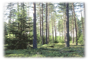
This page has no comments.