Deriving Wind-Wave data from EO
In recent years, there has been an increasing demand for regular information on sea state, including wave conditions. A major driver for ocean wave monitoring and forecasting has been the offshore oil industry, who can suffer significant financial losses due to the interruptions of oil production or platform damage during unexpectedly severe conditions. Accurate wave information is also useful for shipping, coastal engineering, weather forecasting, fishing and even tourism. The developing renewable energy industry also requires such information to ensure optimal siting of both wind farms and experimental wave energy rigs.
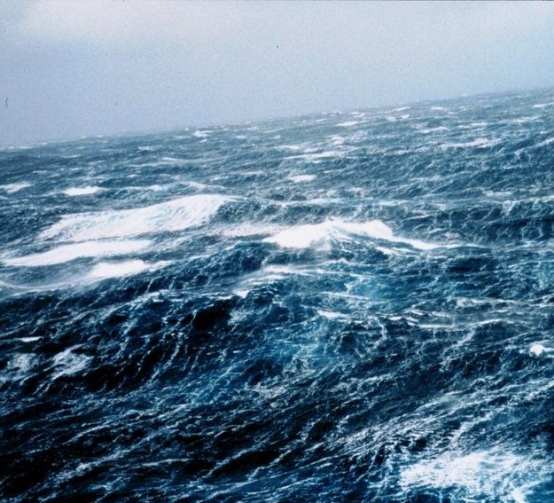
Such wave information can also detect unusual and dangerous sea states, such as ‘rouge waves’ and ‘cross seas’ that are particularly challenging for shipping and offshore installations. Rouge waves, where the wave height exceeds twice the average are poorly understood and under predicted by models. The figure below shows a cross sea, which occurs when two sets of waves travelling from different directions cross at an angle of 45° or more, creating very steep, short-crested waves [1].
Earth Observation is uniquely placed to provide such wave information on a large scale in a timely fashion. Satellite-based RADAR systems can monitor useful parameters such as wave height and direction, wind speed and sea-surface elevation. A significant advantage of using EO is the near ‘real-time’ capability of these systems, with wave information available to users a few hours after acquisition, making it suitable for use in operational weather forecasting, navigation and offshore installations protection.
A number of projects are involved in helping disseminate this highly valuable information such as GlobWave, an ESA commissioned initiative to provide a one-stop shop for all satellite wave data and its associated information in a standard format. This easy-to-access global archive is ideally placed to improve uptake of satellite-derived wave data by the scientific, operational and commercial user communities.
The use of such wave data has been quite diverse. Of particular interest to the oil and gas industry is using these regular wave records in preventative measures to insure offshore assets. As offshore activities increase and expand into more challenging environments, regular monitoring of potential damaging extreme wave occurrences can help in both asset placement and also for preventative measurements prior to a particular wave event. (2)
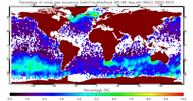
Wave data has also been used in the research communities to in a range of applications including improving wave-forecasting models, as inputs into global climate change models and for monitoring the dynamics of the earth’s ocean. Such information has also been used for further research into unusual wave phenomena. For example, the ability to monitor cross seas using SAR has only recently been developed. A use of such information is to guide shipping away from regions where cross seas are prevalent (see figure beside).
The wide variety of ways in which EO-derived wave information has been used and implemented shows the potential of such datasets to improve safety of marine activities and also potential to extract energy from the oceans. As wave records and forecasting improve and the offshore industry expands accurate wave information will become an increasingly essential tool. With the predicted increased availability of EO data, it is expected such information will become more and more integrated into a wide variety of maritime and coastal systems.
References:
[1]:ESA, 2011, The world Oceans now in one place, http://www.esa.int/esaEO/SEMIGIRHPOG_index_0.html Image copyright from M. Griffon
[2] Globwave, 2011, http://www.globwave.org
Currents and wave forecast |
|
|
| |
wind waves | coastal oceanographic predictions |
| ||
Wave Height Monitoring | Near real-time & archived Global Wave Height records |
|
Article on satellite data enabling forecasts for offshore industry | Metocean, Winds, Waves, Satellite data | ESA | |
Report describing the present status and future prospects for obtaining information on metocean parameters from satellite remote sensing | Metocean, Remote sensing, Satellite data | HSE | |
Brouchure on the metocean forecast service from ABPmer | Metocean, Winds, Waves, Sea states | SEASTATES | |
Report on exploration into Internet-Based Geospatial Technology for | Metocean, Winds, Waves, Satellite data | CARIS | |
Database enabling users to look and see what data are available in specific area of interest, how they are produced and to check and how accurate they are | Metocean, Winds, Waves, Satellite data | BMT ARGOSS | |
Guide to identify and recommend on the uses of metocean data through the life cycle of a marine renewable energy development and serve as a | Metocean, Winds, Waves, Satellite data | CIRIA | |
Metocean Operational Modeling To Support Outfall Construction Along The Coastal Water Of Brazil | Research paper presents the implementation of a meteorological-oceanographic (metocean) operational modeling system to support the construction and deployment of the new ocean outfall in Praia Grande and the expansion of the existing one in Santos | Metocean, outfall, forecast, Metropolitan Region of Santos | ASA |
Article detailing functions and requirements for the development of automatic monitoring stations | Metocean, Winds, Waves | Hydro International | |
Research paper - A systematic validation and comparison of met-ocean parameters like significant wave height (Hs), wind speed (U10) and mean wave period (Tm) obtained from ERS-2 wave mode images using a new empirical algorithm (CWAVE), in situ and satellite observations, reanalysis and model results is presented for the global ocean (requires user to create an account in order to view full text) | Metocean, Winds, Waves, SAR | Academia.edu | |
Presentation on Metocean | Metocean, BP, Winds, Waves | FST | |
Presentation on the hurricane Ivan | Metocean, Winds, Waves, Current | BOEMRE | |
Case study to investigate whether improvement of weather forecasts could result from a better utilisation of satellite observations on a near real time basis | Metocean, Winds, Waves, Satellite data | Ifremer | |
Development of a New Metocean Design Basis for the NW Shelf of Europe | Research paper on the development of a new metocean design basis for a deep water harsh environment off the NW shelf of Europe. | Metocean, Winds, Waves | NWAG |
Presentations from the Floating Systems Workshop re winds, wave calculations etc | Metocean, Winds, Waves | OG | |
|
|
|
|
This page has no comments.