Tides and ocean currents
The rise and fall of tides is a consequence of the effect of the gravitational forces generated by the Moon and the Sun on our planet. Tide waves generate vertical movements of water bodies, while ocean currents are continuous horizontal flows of ocean water which may travel for kilometers; they can be classified as tidal or non tidal, depending on the main factor which generates them. They can be either at the surface level or in deep water, some of them follow repeated paths and have very important influence on climate and ecosystems. Currents are guided by rise and fall of tides, by winds and by thermohaline circulation. Tidal currents change in a very regular pattern and can be predicted with higher precision with respect to other types of currents; winds generate surface currents, while the differences in water temperature and salinity affect currents at different ocean levels (1). Nontidal currents include both the permanent currents in the circulatory system of the sea and temporary currents due to more pronounced metereological variability (2)
Tides and currents have been studied for long, thanks to in-situ measurements and bathymetry. These measurements may nonetheless be biased due to local factors and coastal geometry; moreover computations based on the mass of celestial bodies is subject to errors because the distance and inclination of the Moon and the Sun with respect to the Earth and their reciprocal ones have to be factored in (3).
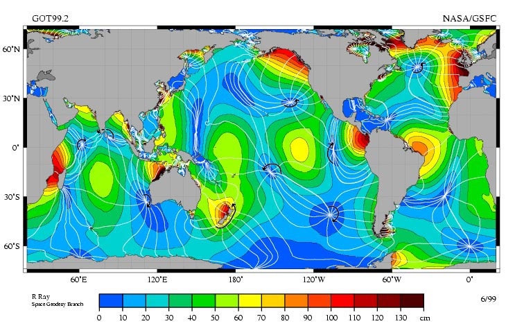
The principal lunar semi-diurnal tidal constituent. Amplitude is indicated by color, and the white lines are cotidal differing by 1 hr. The curved arcs around the amphidromic points show the direction of the tides, each indicating a synchronized 6 hour period. Credits: R. Ray - NASA.
Studying tides is important to understand the vertical mixing of water masses, ocean's circulation and heat distribution which affect the climate of the planet. Remote sensing techniques provide useful information: satellite altimetry can measure sea surface heights with a precision of 2-3 cm (3), and these data then feed mathematical forecast models. Depending on the repeated period of the satellite, tides are measured at the same or different points of their cycle: these are factors to take into account when comparing measurements.
The same satellite instruments also serve to study ocean's currents. Even if satellite altimeters measure the oceans' surface, the information they provide is useful to study deep ocean phenomena as well due to the close relation between the two. Speed and direction of ocean's currents and tides' monitoring are derived from precise measurements of the ocean's surface topography. These are based on the time the satellite radar signal takes to reach the surface and come back. Since mid 90s the establishment of long time series of altimetry data and the simultaneous presence of multiple altimetry satellites in orbit led to higher spatial and temporal coverage and resolution and to an increase in ocean and climate studies based on remote sensing data (4).

Radar altimeter functioning. Credits: CEOS
Oceanography, marine methereology, hydrology, marine geoscience, the study of the cryosphere all benefit from this source of information. The study of currents and tide is also useful for navigation paths, for marine safety and for that of people and ecosystems living in coastal regions. Shipping and sea related infrastructure building, coastal development and engineering also need to be based on these data, as well as tsuanami tracking, hurricane monitoring, emergency preparedness and oil spill monitoring (2).
References
(1) http://oceanservice.noaa.gov/facts/tidescurrents.html
(2) http://oceanservice.noaa.gov/navigation/tidesandcurrents/
(3) http://earth.eo.esa.int/brat/html/appli/ocean/tides_en.html
(4) http://www.eumetsat.int/jason/navmenu.php_page_6.0.0.htm
This page has no comments.