Tsunamis
Natural hazards such as tsunamis severely impact coastal communities and economies. Tsunamis can be invoked by earthquakes, volcanoes, submarine landslides, and, although rarely, meteorite impacts. Most tsunamis occur in the Pacific Ocean and around Japan. Although tsunamis also occur in other parts of the world like for example the Atlantic Ocean, those regions lack the subduction thrust faults that trigger tsunamis.
Although tsunamis can not be prevented, the impact of these natural hazards can be mitigated by accurate forecasting and management of tsunami events. Tsunamis are predicted based on the location, strength, and depth below the surface of a quake. Remote sensing technology can be used to evaluate damage distribution for appropriate emergency management after natural disasters such as tsunamis. It can be used for monitoring, forecasting and early warning which can considerably relieve the impact of this type of hazard. Information derived from satellite remote sensors improves the performance of disaster systems by forecasting risk, tracing hazards, evaluating loss, and guiding relief actions.
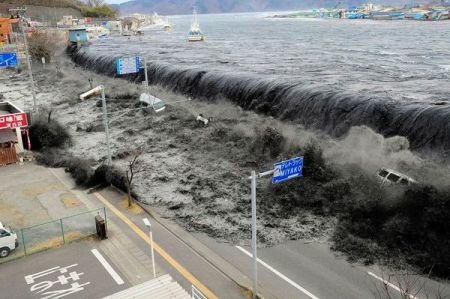
A tsunami wave crashes over a street in Miyako City, Iwate Prefecture, in northeastern Japan on March 2011. Credit: Photograph from Mainichi Shimbun/Reuters
Remote sensing enhances accuracy of data and speeds up data gathering which shortens the delay of early warning and rescue efforts. The data can be used to support the development of tsunami evacuation maps and to improve the existing road network.
It is important to know what type of remote sensing information is suitable for identifying and assessing hazards such as tsunamis. The use of various types of remote sensors depends on many factors including resolution, coverage, frequency and colour contrast. Examples of remote sensors that are used in the field of tsunami monitoring, forecasting and management include: Ikonos, Quickbird, Worldview, ASTER, Landsat and LiDAR. A new application of Interferometric Synthetic Aperture Radar (InSAR), called Dynamic InSAR has the potential to image seismic surface waves in real time and can be used to complement existing in situ instruments to provide a global tsunami monitoring system. A SAR is a particular kind of radar system which can obtain high resolution data from large areas, regardless weather conditions and day/night cycle. These characteristics make this technique a very versatile solution for continuous global monitoring. Dynamic InSAR can detect a tsunami’s amplitude and track its speed and direction of travel. Tsunamis are waves with long wavelengths that allow them to travel across oceans with little loss of energy. When reaching the shore, the ocean bottom forces an increase of the wave height to as much as 30 feet (10 meters). When still travelling over the open ocean, the tsunami amplitudes are less than one meter and not visible to optical satellites, but they can indeed be detected and measured by Dynamic InSAR technology.
Examples of remote sensing data and software which were used for the December 26, 2004 tsunami are SPOT and IKONOS imagery. This technology was used to detect the progression of tsunami waves and sediment change, and to obtain damage details. MODIS data were used to map coastal flooding, sediment load and trails during propagation and after impact on coastlines. Landsat, and the Indian Oceansat-1 and Resourcesat were used for analysis and damage assessment.
To forecast and mitigate the impact of tsunami hazards, globally there are a number of organizations and programs involved, such as the U.S. National Tsunami Hazard Mitigation Program (NTHMP), the Intergovernmental Oceanographic Commission (IOC) and The International Coordination Group for the Tsunami Warning System in the Pacific (ICG/ITSU), the International Tsunami Information Center (ITIC), the Pacific Marine Environmental Laboratory (PMEL) and NOAA's Pacific Tsunami Warning Center (PTWC). The European and French space agencies (ESA and CNES), together with the Canadian Space Agency (CSA), have initiated the International Charter ‘Space and Major Disasters’, which is an internationally operating satellite information network to mitigate impacts from hazards such as tsunamis.
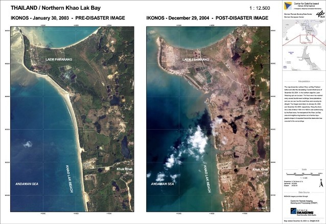
Credit: Remote Sensing Data Centre, DLR - German Aerospace Center Ikonos imagery provided through Center for Remote Imaging, Sensing and Processing, Space Imaging.
Success Stories
|
|
|
|
|---|---|---|---|
|
|
|
|
References
Topic | Description | Keywords | Reference |
|---|---|---|---|
|
|
|
|
This page has no comments.