The Sullom Voe region on the Shetland Islands is a region of large contrasts. Being a designated Special Area of Conservation, it is also the location of the biggest oil and gas terminal in Europe – the Sullom Voe Terminal. The terminal is one of the biggest and most complex of its kind in Europe, with a high operational turnover. As a result, there is the potential for large and irreparable risks (e.g. one of the biggest concerns regarding work that takes place at Sullom Voe is the effect of effluent discharge from the terminal and its effects) to the surrounding environment.
GeoVille, specialized in the development and application of state of the art satellite remote sensing and Geographic Information System (GIS) based spatial analysis techniques, was contracted to monitor land cover and land use as well as their changes in the area of the Sullom Voe Terminal. The monitoring was commissioned by BP to support environmental assessment and to provide guidance to minimize ecological impacts and to value ecosystem services in the region.
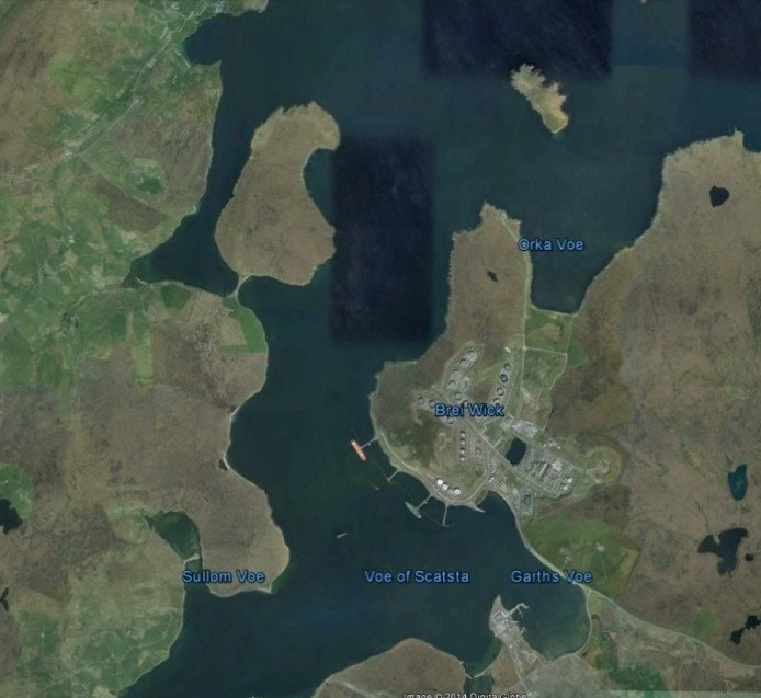
Figure 1: Sullom Voe Terminal as seen from Google Earth
Oil in the East Shetland Basin was first discovered in 1972 and the importance of Shetland’s location to the oil industry was immediately recognised. What had initially been a community dominated by a fishing and crofting economy, suddenly experienced a drastic transformation. Between 1975 and 1981 the BP-operated oil terminal was build towards the northern end of the largest of the Shetland Islands occupying 1000 acres. Today Sullom Voe Terminal is one of the biggest oil and liquefied gas terminals in Europe. On average more than 150,000 barrels of crude oil flows via the Brent and Ninian pipelines from the oil fields in the North Sea to the Sullom Voe Terminals every day and get loaded on tankers at Sullom Voe harbour.
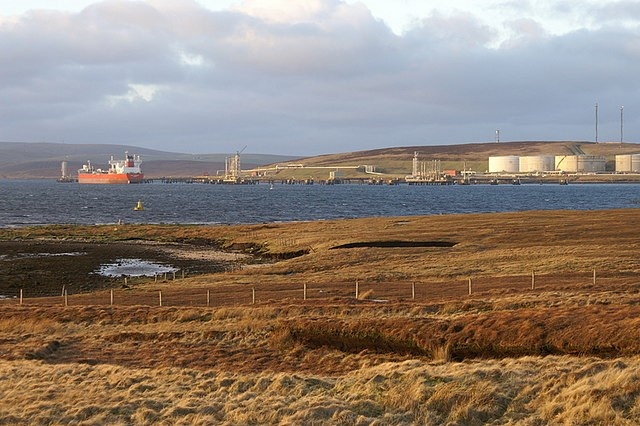
Figure 2: Sullom Voe Terminal (left) and a typical inlet of the region (right)
The Sullom Voe Terminal has naturally beautiful coast and sea surroundings and support a rich and diverse wildlife, which needs to be preserved. This was officially recognised in 2004 after Sullom Voe’s special geographical and biological features – which remain unspoilt due to more than thirty years of high quality marine environmental management – led to its designation as a Spacial Area of Conservation (SAC) by the European Commission. To protect this unique nature as well as to identify ecosystem service dependencies and its impacts, a demanding monitoring system is essential. Especially, exact land use and land use change maps are crucial to monitor the habitat and to define ecosystem services that are provided by the region (e.g. mussle beds, peatlands, etc.). These information can then be linked to socio-economic data in order to give an economic value to the provided ecosystem services, according to their uses such as mussel farms, fishing and recreation.
GeoVille produced satellite-based land cover and land cover change maps to support the ecosystem service assessment in the area of the Sullom Voe Terminal. Very high resolution optical satellite imagery (Quickbird and IKONOS) were used to produce land cover and land use maps for the reference years 2003 and 2013, as well as land cover and land use change maps for the period 2003 to 2013.
The processing chain to establish the very high-resolution land cover and land use mapping as well as their changes was based on GeoVille’s RegioCover© processing suite, assembling state-of-the-art Earth Observation and geo-spatial technologies for efficient large area information retrieval and mapping from remote sensing data. RegioCover© is a highly-automated land cover and land use mapping solution that transforms satellite imagery from optical and radar data into intelligent geo-information using leading industry software packages, such as ERDAS Imagine, Definiens eCognition, and ESRI ArcGIS. RegioCover© has received the Definiens/ESA/EC GMES Innovation & Research Award for its innovative and outstanding geo-information processing.
Land cover and land use at Sullom Voe for the years 2003 and 2013
The very high-resolution satellite data (spatial resolution below 1 m) enabled the development of a detailed land cover and land use classification map for the Sullom Voe oil and gas production site on the Shetland Islands for the reference years 2003 and 2013 (Figure 3). The information derived from these maps can be further used as key input for ecosystem valuation.
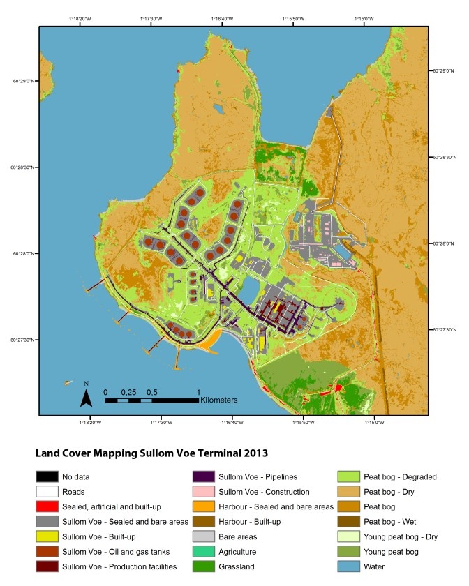
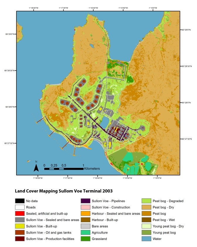
Figure 3: Land cover/use map 2003 and 2013 (Source: GeoVille)
Land cover and land use change at Sullom Voe for the years 2003 to 2013
The land cover and land use maps for the reference years 2003 and 2013 provided the baseline for the land cover and land use change map of the region. Figure 4 shows the produced land cover and land use change maps. The changes were integrated into the existing land cover and land use map (left) and additionally delivered as a stand-alone change product (right). The maps provide important information on land cover and land use dynamics at Sullom Voe between 2003 and 2013 and indicate areas that are strongly influenced by the terminal’s activities.
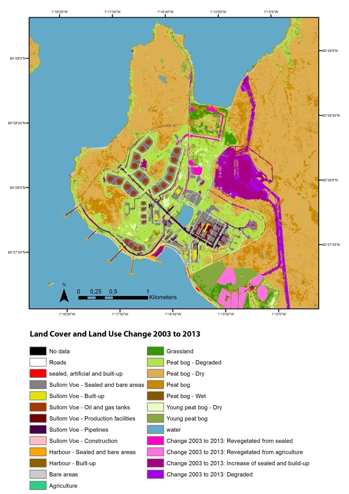
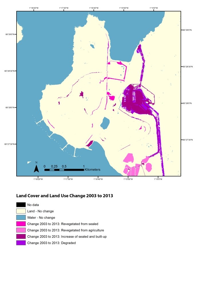
Figure 4: Land cover/use change map 2003-2013 (Source: GeoVille)
By using very high-resolution satellite imagery it was possible to provide a detailed land cover and land use classification for Sullom Voe for the reference years 2003 and 2013. The maps are a basis to identify the biological and environmental importance of the ecosystem services at Sullom Voe. This information is essential to recognize ecosystem service dependencies and the impact of the terminal operations. Based on this information, future management decision can be made to mitigate any direct and indirect impacts from Sullom Voe Terminal’s current and future activities. Potentially, a sound ecosystem service monitoring system could result in increased material cost savings and potential new revenue streams arising from new market-based mechanisms like carbon, biodiversity and other payments for ecosystem services.
Contact
GeoVille is a private sector enterprise located in Austria and Luxembourg. GeoVille specialises in products and services related to Earth Observation (EO) and Geographic Information Systems (GIS) applications.
GeoVille is Europe’s leading company in using satellite data for land monitoring and spatial planning applications.
Our services provide the bridge from user needs to technical implementation - merging geospatial explicit data with statistics - to the analysis of what on-going processes and trends mean for real world applications.
GeoVille Information Sytsems GmbH
Sparkassenplatz 2, 3rd floor
A - 6020 Innsbruck
Austria
Email: info@geoville.com
Web: www.geoville.com
This page has no comments.