
 The complexity of modern urban environment requires the ability to handle a great number of various types of data “spatially”-with spatial reference and topological structure. Public demand for good urban governance (related to economy, environment, and/or social issues) and efficiency improvement has brought the need for more sophisticated Systems; as cities expand vertically a 3d topological structure of LISs (or 3d-GIS) is already used. This project developed an advanced 5D Multi-Purpose LIS (Land information System), based on existing 3d packages (traded by the two participating enterprises) for integrating and managing various types of information (financial, architectural, topographical, cadastral, valuation, engineering, ownership, etc.) from governmental, regional and local databases at 3d spatial dimensions + time + scale. The system will allow representations and analysis of real estate properties and man-made features in three physical dimensions (X,Y,Z), through time (planning phase, development phase, registration phase, modification phase, and so on) and at varying scales (level of detail).
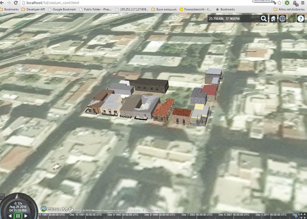
Fig 1. Cesium visualization in 4D (3-D + time) using CZML and bglTF formats
 Urban populations are growing faster than at any moment in history. This explosion in population and density of modern cities is presenting new challenges for governments, developers, designers, citizens, and other stakeholders resulting from the massive deployment of information sources in cities around the world. The issue of adequate and affordable housing is addressed separately from general land development as there is a global understanding that market alone cannot satisfy this need and special tools and regulations need to be developed, within the free market economy, in order to ensure the sustainable development goals. In order to support the global trends in the management of land and real estate researchers are expected to provide tools that will be functional, reliable, affordable, inclusive & fit-for-purpose, capable to satisfy a world that cannot wait. 5DMupLIS is a technical tool that helps all partners involved in the management of land and real estate (governments, private sector and professionals, citizens) to implement modern policies and develop fit-for-purpose solutions for the “best use” of the urban land. Moreover, through the application for affordable housing provision, it can support self - financed, small projects for urban regeneration, creation of green public spaces within the urban neighborhoods, encourage policies to mitigate and adjust to climate change situation and most important to plan for affordable housing provision with the contribution and involvement of the private sector and the voluntary participation of the property owners.
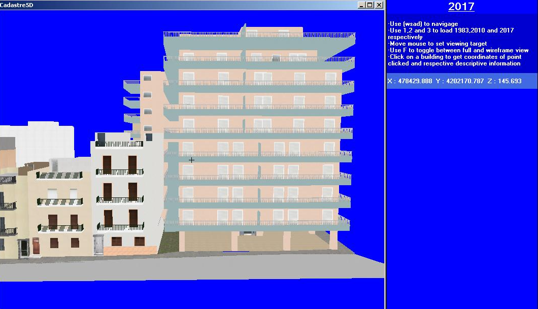
Fig 2. LOD3 in the future time instance (e.g., 2017)
The main objective of this study is to “develop an appropriate technical tool that will support land management interventions to deal with the emerging global challenges within the current international trends and the global policy framework for good land management”. This tool is expected to enable public agencies, private sector, and citizen to cooperate more efficiently together to develop the strategy, set the regulations and implement land management policies through a fit-for-purpose geospatial infrastructure, that will collect, manage and disseminate geospatial data about the ownership, use, development procedures, value of properties, and housing aspects by
(i) improving access to geospatial data across agencies and removing redundancies and duplication of work,
(ii) enhancing land management services and geospatial information provision and exchange between government and citizens,
(iii) improving response times and reducing costs,
(iv) enabling better coordination between the
public and private sectors,
(v) enhancing the provision and dissemination of public services by the support and the greater involvement of the private sector and the participation of citizens, and
(vi) improving transparency, democracy and engagement in decision making at all levels. The above is aligned with a global need for good land management as identified and agreed by all major international organizations (e.g., International Federation of Surveyors –FIG, UN, the World Bank, etc) and is included in their studies and proposals, aiming to achieve economic
To achieve this objective, the following methodology was selected:
a) For Identification of the global challenges and the policy framework, the potential users and their needs a technical research is made to identify and develop the best methodology for a cost- effective 3D modelling creation and updating through time. Semi-automated approaches using dense image matching (Semi-global matching technique) and Structure from Motion methods are applied for the creation of textured 3D models;
b) Collection of additional cadastral information about the individual units and the right holders in order first to update the administrative cadastral information in the area under study for the present time period and second to understand the duration of the existing property rights through time by introducing the 4th dimension in the cadastral database;
c) Additional information is added about the construction material, age, location, orientation, etc., that will allow the reliable property valuation of those units and the estimation of the value of the property of each right holder in the case study area. The final products of this procedure are the input data (the 5DMuPLIS database with geometric and attribute data) for the visualization module of the “5DMuPLIS technical tool”;
d) Two viewers were developed. The first viewer (KML/CZML Viewer) allows the user to interactively visualize the 5 dimensions’ data (3D+time+scale) from the 5DMuPLIS database using either Google Earth or directly in a web browser (via the Cesium 3-D globe library). The viewer currently supports four different visualization modes of the input data and is very flexible and able to provide different information and to target different applications/user needs. The second viewer (LoP5Dv) is custom made software that was developed from scratch without the use of any commercial, open source or other existing API or library.

Fig 3. Methodology implemented for the creation of the 3D textured models of building
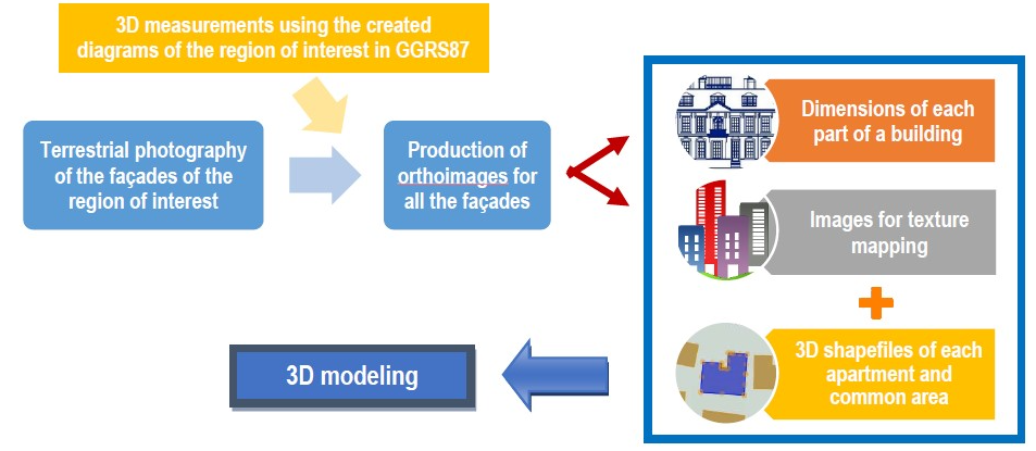
Fig 4. Selective (predictive) 3D modelling architecture
Contact info
Contact person: Betty Charalampopoulou
E-mail : mail@geosystems-hellas.gr
Participants in the project: GEOSYSTEMS HELLAS S.A. - GSH (coordinator), Laboratory of
Photogrammetry - National Technical University of Athens (LOP/NTUA), Visual Computing Lab Information Technologies Institute, Centre for Research and Technology Hellas, Thessaloniki, Greece (CERTH-ITI-VCL).
This page has no comments.