Ship detection
Oceans occupy more than seventy percent of the Earth surface. Vessels detection and identification has always been a challenge, especially in areas which are far from the continents' coastal lines. Traditionally information was gathered from coastal radars and shore based Automatic Identification Systems (AIS): ships travelling the open ocean were undetected, resulting in limited knowledge of maritime traffic and activity (1).
Remote sensing and satellite technologies give the possibility of detecting vessels in the wider ocean, but pose challenges as well. Those mentioned in the exactEarth white paper (2) are the following:
- the large amount of information makes it challenging of identifying interesting vessels' behaviour
- the capability of integrating Satellite AIS with Space based Radar satellites infromation still needs to be fully developed
- saturation of satellite receivers with too much signal
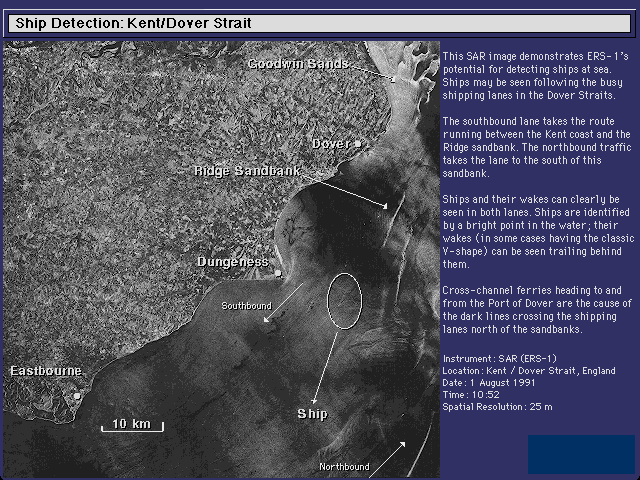
Satellite borne SAR instruments offer data to detect ship in the opean sea and to measure, through wake and Doppler displacement, their speed and direction (2).
Ship Detection: Kent/Dover Strait Image © ESA
European satellites are for example COSMO-SkyMed, RADARSAT1 and 2, ENVISAT, ERS-2, SPOT, Pleiades FORMOSAT-2, TerraSAR-X and TanDEM-X. Copernicus Sentinel 1A and Sentinel 1B will gather useful data as well. Among the most important characteristics of useful satellite data there is the high revisit frequency, together with high spatial resolution observing models. Gathered information is not just about spatio-temporal detection of the ships: also estimation of side speed and direction is possible. Detected vessels and boats can be as small as 5 meters lenght and near-real-time information delivery as quick as within 15 minutes from image acquisition (3).
Spectrum Decollision Processing is a technique of processing Satellite AIS data for leveraging imaging acquired by radar satellites. It corellates ship positions with radar images and captrure position reports about the static and vouage information transmitted by ships. All these data, together with other ship registry information let authorities confirm the ship is the ship it claims to be; cross checking of position and course over ground is also possible. The radar image provides a virtually complete detection of large ships, but a quick identification of interesting ships is possible via the Satellite AIS data (if they report on most of the ships captured in the image (2).
Fusing Satellite AIS with radar and optical imagery can generate more and more accurate pictures of the marine area and provide near real-time data, without the need of interpolation or forecasting. Moreover it improves ship validation and accuracy of identification. Search and rescue efforts can benefit from such data as well, enhancing planning efficiency both for routine and emergency situations; this process is easier if ships are broadcasting their position and have access to radio communications. Examining traffic patterns and study common routes allows for the construction of historical analysis and archives which are then useful for real-time detection (2).
References
(1) exactEarth White Paper, Satellite AIS and First pass detection 2012.
(2) http://www.e-geos.it/applications/maritime.htm
(3) http://www.astrium-geo.com/en/4445-ship-detection-tracking
Products | Ext. Source | Descriptions | Product Standards | Ref. Project |
|---|---|---|---|---|
|
|
|
|
|
|
|
|
|
|---|---|---|---|
|
|
|
|
Topic | Description | Keywords | Reference |
|---|---|---|---|
|
|
|
|


This page has no comments.