Monitoring illegal fishing
Around fifteen percent of the global population depends on seafood as their main source of protein or even as their only food supply. However, extensive fishing activities, both legal as illegal have led to most fish stocks being overexploited, including the ones in European waters. In 2010 IUU fishing (Illegal, Unregulated and Unreported fishing) had been estimated to cost the European Union 10-20 billion Euros annually, with 1.1 billion Euros worth of illegal fish being imported into the European Union every year. If current fisheries activities persist, it is estimated that the collapse of all fisheries will take place by the middle of this century. Improved fisheries monitoring and management should be applied to prevent this happening.
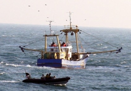
A UK Royal Navy patrol ship issues a fine to fishermen using undersized nets in the North Sea.
Identification, detection and tracking of vessels can best be accomplished by space-based Earth observation systems including Synthetic aperture radar satellites (SARsats), electro-optical/infrared (EO/IR) imaging satellites and communication based systems such as the Automatic Identification System (AIS), VMS (Vessel Monitoring System) and LRIT (long-range identification and tracking). Ship detection from remote sensing imagery has proven to be a crucial application for mitigating IUU fishing. Since VMS, AIS and LRIT are limited because these systems depend on cooperation from the vessels, satellite imagery has the advantage that it can potentially detect all fishing vessels, including those without VMS, AIS or LRIT components or willingness of active participation of the vessel involved.
Monitoring illegal fisheries is a very challenging undertaking because of various factors. Because ships are moving targets the positioning needs to be communicated in real time. The oceans and seas are vast areas that need to be scanned while at the same time it should be possible to zoom in on various activities. The marine environment produces a cluttered background because of wind and waves, which potentially obscures small boats and may trigger false alarms.
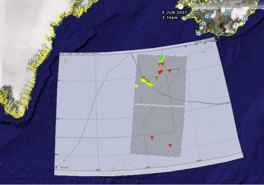
IUU detection. Credit: Kongsberg
Satellites can monitor ships optically or with synthetic aperture radar (SAR). Though optical imagery may be distorted by atmospheric interruptions such as cloud cover and darkness, high- resolution optical imagery such as SPOT, EROS, IKONOS, and QUICKBIRD can be used to detect ships in detail (though to a certain extent). It is possible to detect and even identify the larger vessel types such as container ships, oil tankers and bulk carriers. Small vessels can be detected but not classified. The swath of high resolution imagery is relatively small, rendering SAR imagery advantageous due to its ability to scan large areas and its independence from atmospheric conditions. A combination of optical imagery and SAR enables good surveillance over the oceans because of the wide swath from SAR, while details may be provided by optical satellite imagery.
Modern remote sensing technologies for fisheries control may not replace traditional control and surveillance methods, such as inspections onboard vessels or on shore, but may significantly reduce the total costs for fisheries monitoring and surveillance, because they are more cost effective. A combination of all systems and crosschecking of data enables fisheries authorities to improve control strategies and detect illegal activities that could otherwise go unnoticed. The most effective method to detect IUU fisheries seems to be the use of Synthetic Aperture Radar (SAR) for detection, Optical imagery for recognition and correlation with AIS, VMS and LRIT.
Many countries have developed strategies to deter and fight illegal fishing activities. They are internationally cooperating through various programs such as the International Plan of Action to prevent, deter and eliminate IUU Fishing (IPOAIUU) that has been developed within the framework of the Code of Conduct for Responsible Fisheries by the FAO. The European Union has formulated several regulations to further mitigate IUU fisheries. Projects that have been run by the Joint Research Centre include DECLIMS (Detection, classification and identification of marine traffic from space) and IMPAST (Improving fisheries monitoring through integrating passive and active satellite based technologies). Project SAFARI and NEREIDS aim to accelerate the assimilation of satellite Earth observation data into fisheries monitoring and management on a global scale. EMSA, NOAA, IMO and other organizations like GEO, GMES, NERC, POGO, IOCCG and GOOS are also actively involved to identify opportunities for enhanced utilization of Earth Observation data in fisheries management.
Products | Ext. Source | Descriptions | Product Standards | Ref. Project |
|---|---|---|---|---|
|
|
|
|
|
|
|
|
|
|---|---|---|---|
|
|
|
|
Topic | Description | Keywords | Reference |
|---|---|---|---|
case study | illegal fishing, catapult | Satellite Application Catapult Case study |
This page has no comments.