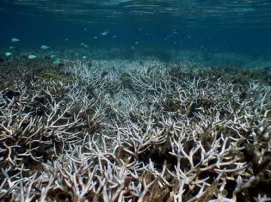
Coral reefs represent highly biologically diverse and economically viable ecosystems. Unfortunately these precious ecosystems are under major threat due to a range of human activities and global climate change. Large scale coral bleaching and mortality resulting from ocean acidification, rising sea levels and sea surface temperatures (SSTs) is being reported from around the world. Improper fishery, coastal pollution, habitat destruction from tourism and coastal development are examples of the many direct anthropogenic stressors causing the coral reefs to decline.
The complexity of cumulative and interactive stresses on coral reef ecosystems makes it very difficult for coral reef managers to know what actions to take. Complementing the costly and time consuming in-situ measurements from, for example, vessel-borne and underwater sensors, with satellite based coral reef monitoring is highly recommended. The use of satellite remote sensing contributes to our understanding of these complex ecosystems and their threats by providing spatial and time-series data of environmental parameters in near-real time.
Advanced protection and management of coral reefs is possible with space borne remote sensor data that can be used to study reef carbonate dynamics, bathymetry, geomorphology and biodiversity of coral reefs. Modernized sensors and algorithms can be used to gather information about biological characteristics of coral reefs and physical parameters such as waves, currents, sea surface temperatures (SSTs), precipitation, solar radiation, salinity, wind speed, chlorophyll-a and suspended sedimentation.
Bleached corals. Credit: NOAA/D.Burdick
Global cooperation of institutes and programs has been established to enhance our understanding of coral reef ecosystems, so that coral reef management and policy actions can be developed and improved world wide. Examples of notable organizations and programs involved are the Global Environment Facility (GEF), World Bank, International Panel for Climate Change (IPCC), United Nations Environmental Program (UNEP), World Conservation Monitoring Centre, International Coral Reef Action Network, MyOcean, the International Center for Living Aquatic Resources Management, NOAA Satellite and Information Service (NESDIS), Millenium Coral Reef Mapping, ReefBase, ReefCheck, Reefs at Risk and the Coral Reef Targeted Research and Capacity Building for Management (CRTR) Program.Satellite derived coral reef mapping can be most valuable in designating and managing marine protected areas (MPAs). Due to reef development and oceanographic processes, many coral reefs develop a distinctive pattern of geomorphologic zonation. Typical zones such as fore reef, reef crest, reef flat, back reef and lagoon are characterized by specific depth distributions and benthic communities. Detailed mapping of habitats/geomorphology, mangroves, sea grass beds, reef community type, beta diversity, connectivity, live vs. dead corals, reef structural complexity, coral bleaching events and the physical environment e.g. bathymetry, water quality, wave exposure and coral bleaching and coral disease risk maps has been improved with moderate to high- resolution sensors such as Landsat TM, MERIS, MODIS, Sea-WiFS, SPOT, ASTER, IKONOS and Quickbird. Examples of coral reef remote sensing applications can be found in the Coral Reef Targeted Research & Capacity Building for Management (CRTR) directory.
Integration of satellite based monitoring and in-situ measurements contributes to the forecasting of mass coral bleaching events. Satellites provide information on sea surface temperature (SST) and solar radiation such as photosynthetically active radiation (PAR) and UV. Coral bleaching occurs as a result from elevated sea surface temperatures (SSTs) and either PAR of UVB or both. SST is an important environmental parameter for coral reef management. The HotSpot and Degree Heating Week (DHW) are remote sensing products specifically designed to forecast thermal stress related coral bleaching. HotSpots are temperature anomalies that exceed the Maximum of the Monthly Mean SST (the MMM climatology). The cumulative effect of the thermal stress as indicated by the HotSpots is defined by DHW. This thermal index greatly contributes to the accurate prediction of coral bleaching events.
A suite of near real- time HotSpot products provided by NOOA’s Coral Reef Watch (CRW) global satellite support the Satellite Bleaching Alert System (SBA) which is an automated email alert system. An email is generated and sent to all subscribed coral reef managers whenever a coral reef’s status level of thermal stress changes or when the DHW exceeds the historical DWH. The status level of a coral reef site is updated twice a week, using five classes: no stress, bleaching watch, bleaching warning, bleaching alert level 1, bleaching alert level 2.


This page has no comments.