Assessing Climate Vulnerability and Adaptation
Climate change adaptation and mitigation and have been defined simply as (J. Holden, Harvard University):
• Adaptation: Managing the Unavoidable
• Mitigation: Avoiding the Unmanageable
These definitions, together with assessing climate vulnerability and resilience point to a need for information about the Earth’s environment; past, present, and future. EO is a key source of information for the first two requirements, and is an important input to the third.
Many applications related to climate are described in specific sections, in particular those linked to extreme weather-induced disasters (i.e. adaptation) and clean energy production (i.e. mitigation). For example, EO data can help better quantify the flood risks in coastal cities, resulting from the combined effect of sea-level rise, coastal erosion, and subsidence/uplift (resulting from human activities such as water pumping). Long-term archive of EO data also provide useful information on natural resources, such as offshore wind, solar irradiance, met-ocean conditions, which provide renewable energy managers with a first assessment of the amount of potentially available renewable energy.
A few further examples of how EO information is customised and exploited to support climate change assessment and the green economy are given below. Current climate hazards and long-term climate change have been identified as significant environmental and developmental issues in Cambodia. Climate variability and extremes are projected to increase, causing floods, droughts, storms, increased coastal erosion, heat waves, and outbreaks/intensification pests and diseases.
Increase in temperature, rising of sea level, and changes in rain patterns pose significant risks to the already vulnerable agriculture and fisheries sector as well as rural livelihoods.
This activity (carried out for Asian Development Bank and World Bank) integrated EO information (land cover, land use) together with existing vulnerability and assessment literature, combined with consultations with government agencies (at the national and provincial levels). In-depth assessments were conducted in four target provinces (Battambang, Kampong Thom, Prey Veng and Stung Treng) to obtain an understanding of sub-national levels of climate change vulnerability.
The analysis provides a scientific, evidence-based assessment of climate-related vulnerability, and recommendations for enhancing adaptation to climate variability and change in key sectors (agriculture, water resources and infrastructure development).
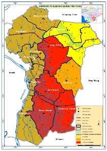
Exposure map to climate hazards for the province of Prey Veng.
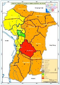
Adaptive capacity map to climate hazards for the province of Prey Veng
References:
ESA 2013, Earth Observation for Green Growth: An overview of European and Canadian Industrial Capability
climate change applications |
|
|
| |
time series changes on climate |
|
|
This page has no comments.