Inland water quality
The service provides information concerning inland water quality, both regarding chlorophyll content and suspended matter. Total suspended matter (TSM) and/or turbidity maps is provided in the unit milligram per litre [mg/l]. Chlorophyll a is one essential pigment included in phytoplankton cells and therefore a measure of phytoplankton. The common unit of chlorophyll is [μg/l]. Products of the different satellite sensors can be used, like MERIS, MODIS Aqua/Terra, to provide consistent, simultaneous measurements within a range of 0.1-0.2 mg/l for suspended matter and 1 μg/l for Chlorophyll.
The period and update frequency depends strongly on cloud-cover for the lake in question. Normally for this type of this service, the satellite sensor MERIS is used as baseline to generate 300m resolution products up to 10-20 times per year. This baseline service can be complemented with more high-resolution satellites like Rapideye to provide a spatially high resolution product (down to 5 meters) but with less frequent updates (3-5 times per year).
The final quality of the satellite water quality products will depend heavily on the availability of in-situ ground measurements in order to validate the EO based products due to the different nature of individual lakes and their height above sea level (for atmospheric corrections). Having available in-situ measurements one can achieve accuracies of both chlorophyll and suspended matter in the order of 90%. The geometric accuracy depends on the spatial resolution of input EO data, typically < 1 pixel. Historical data sets can be obtained from
the archives to provide for trend analysis of water quality, and to monitor impacts over time of corrective actions to improve the lake ecological situation. Typically datasets from MERIS can be obtained globally for the last decade, but not all data pass the quality control due to strong haze, sun glint or problems with the satellite raw data.
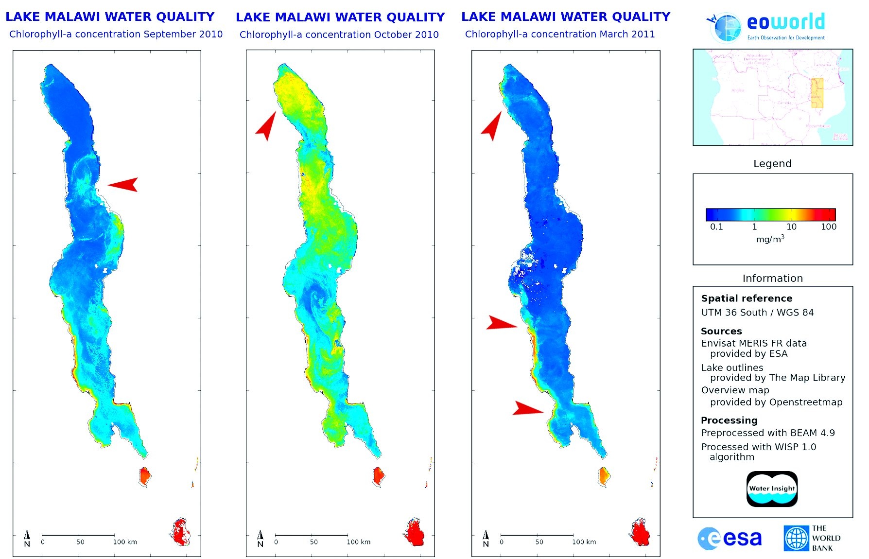 Red arrows points to chlorophyll-a plumes caused by riverine influx. Credit: WaterInsight.
Several factors threaten the ecological state of lakes, including issues relating to harmful algae, toxic chemicals, dis-charges from vessels, aquatic invasive species, habitat degradation, and the effects of climate change. Monitoring these issues is critical for local sustainable management of lakes and satellites are particularly suitable for observing relevant water quality parameters like phytoplankton and total suspended matter.
Colour Instrument (OLCI) is based on heritage from Envisat's Medium Resolution Imaging Spectrometer (MERIS). With 21 bands, compared to the 15 on MERIS, a design optimised to minimise sun-glint and, a resolution of 300 m over all surfaces. The pair of Sentinel-3 satellites will enable a short revisit time of less than two days for OLCI and less than one day for SLSTR at the equator.
References:
ESA 2013, Earth Observation for Green Growth: An overview of European and Canadian Industrial Capability
Products | Source | Descriptions | Product Standards | Ref. Project |
|---|---|---|---|---|
water quality |
| river discharging |
| |
water layer |
|
| Euroland (Geoland2) | |
mapping wetlands |
|
| ||
water scarcity |
| satellite-measured water cycle parameters | ||
water access |
| water management: integrate data from EO, meteorology and catchment modelling to better access hydrological processes |
| |
bathing water indicators (ocean color products) |
|
|
| |
| pollution in rivers and lakes |
Topic | Description | Key words | References |
|---|---|---|---|
|
|
|
|
This page has no comments.