Assess and Monitor Volcanic Activity
Volcanic disasters have killed many people and caused property damage and great economic loss. Volcanic eruptions are hazardous for people and the environment not only directly surrounding the volcano but also further away because of drifting volcanic clouds. The ascent of magma coincides with earthquakes, surface deformation and the release of various hazardous gases.). Globally there are a number of volcano observatories operating with the attempt to anticipate, assess and mitigate volcanic impacts. Because volcanic ash is extremely dangerous for air traffic there have also been developed numerous Volcanic Ash Advisory Centers (VAACs. Satellites play a key role in the forecasting and assessment of volcanic eruptions by providing a global perspective of tectonic strain across continents at high temporal resolution and by allowing assessments of volcanic activity in remote and inaccessible terrain.
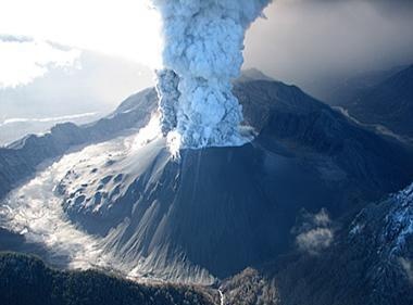
View of an eruption column from Chaitén Volcano, Chile, May 26, 2008. The caldera is about 3 km in diameter. U.S. Geological Survey photograph by J.N. Marso.
Remote sensing techniques based on satellite and radar observations are critical for issuing Volcanic Ash Advisories (VAAs) and Significant Meteorological Information (SIGMET) to aircrafts. Real time observation and forecasts from satellite remote sensors about volcanic ash and sulphur dioxide clouds helps to improve aviation safety. Known as the “split-window” or “reverse absorption” technique, a sequence of split window images from multispectral earth observation techniques such as AVHRR and MODIS for example, can be generated to distinguish different cloud formations and constituents such as sulfur dioxide (SO2) and sulfates. Modern techniques such as MODIS, SPOT, Landsat, AVHRR, (A)ATSR, SEVIRI, AIRS and IASI, MISR, and ASTER are promising when it comes to providing more accurate estimates of ash cloud area coverage, cloud top height and other parameters.
InSAR (Interferometric Synthetic Aperture Radar) is often used to map terrain deformations, such as those that can occur before a volcanic eruption. Interferometry is a remote sensing technique where two or more radar images over the same area are combined to detect slight surface changes occurring between acquisitions. Small changes in the ground such as movement of magma underground causing deformation of the surface above generate changes in the radar signal and lead to rainbow-coloured interference patterns in the combined image, known as a ‘SAR interferogram’. InSAR therefore is very equipped to monitoring earth deformations due to volcanic or tectonic activity, and proves to be particularly useful for the tropics where cloud cover can obscure visual observations.
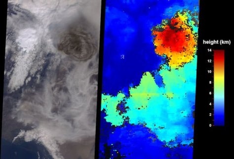
MISR images of an eruption cloud from the Grimsvotn Volcano in Iceland at 1300 UTC on 23 May 2011 from the visible band (left), with the accompanying cloud top height (km) analysis (right). (Source: NASA)
As the Iceland’s eruptions of Eyjafjallajökull in April 2010 and Grímsvötn in May 2011 demonstrated, volcanic outbursts can have a huge impact world wide. Air traffic had been temporarily suspended throughout Europe, affecting economic, political and social activities globally.
Under the Global Monitoring for Environment and Security (GMES) programme, a new constellation of satellites called the Sentinels is being developed that will provide a wealth of new satellite data and products that better meet for the assessment and management of geo-hazard risks. Sentinel-1 will be a key source for systematic terrain deformation monitoring, while Sentinel-2 will provide high-resolution multispectral imagery to support hazard management. Sentinel-3 will render high temporal thermal-infrared imagery to support lava flow monitoring.
Globally there are a number of meteorological organizations involved in monitoring of the atmosphere. International bodies such as the WMO, EUMETNET, ICAO and EUMETSAT recognize the importance of sharing data, to cooperate through comprehensive networks of weather observations, and to establish and improve standards and guidelines on volcanic ash. International institutions such as WOVO (World Organization of Volcano Observatories), IAVCEI (International Association of Volcanology and Chemistry of the Earth’s Interior) are specifically aimed at assessing and monitoring volcanic activity.
This page has no comments.