Environmental Impact of Farming
The negative environmental impacts of farming for which EO geo-information services can provide support for both management and policy makers are:
Loss of habitats
Agriculture ecosystems provide important habitats for many wild plant and animal species. This is especially the case for traditional farming areas that cultivate diverse species. However, rising demand for food and other agricultural products has seen large-scale clearing of natural habitats to make room for intensive monocultures. Land which is converted from its natural state for farming leads to the loss of biodiversity and the support environment.
EO geo-information can provide large-scale monitoring of the change in land environment and improve management practice as well as instruct policy makers. Two major European projects are concerned with biodiversity:
- BIOSOS, Biodiversity Multi-SOurce Monitoring System: From Space To Species is a project that aims to develop tools and models for consistent multi-annual monitoring of NATURA 2000 sites and their surroundings. The emphasis of the project is on NATURA 2000 sites in the Mediterranean part of Europe, but also sites in the Netherlands, Wales and even the tropical rainforest of Brazil are included.
- MS-Monina; Multi-scale service for monitoring Natura 2000 Habitats of European Community Interest, offers remote sensing based monitoring services for observing and managing the state of NATURA 2000 sites and other precious habitats to reduce the loss of biodiversity.
Water use
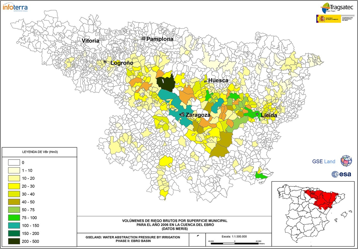
Water volumes requested forirrigation by single municipalities in the Ebro basin (Spain) in 2006. Credits: Tragsatec
Globally, the agricultural sector consumes about 70% of the planet's accessible freshwater more than twice that of industry (23%), and dwarfing municipal use (8%). A significant proportion - estimated at 15-20% is unsustainable leading to the depletion of aquifers and lowering the water table. The main causes of wasteful and unsustainable water use are:
- leaky irrigation systems
- wasteful field application methods
- cultivation of thirsty crops not suited to the environment.
Excessive irrigation can also lead to pollution through run-off containing nitrates and pesticides that impact other environments including the marine and coastal.
EO geo-information services can monitor soil moisture levels down to fine scales and help manage irrigation practices as well as reducing water use.
Soil erosion
When natural vegetation is cleared and when farmland is ploughed, the exposed topsoil is often blown away by wind or washed away by rain. Soil carried off in rain or irrigation water can lead to sedimentation of rivers, lakes and coastal areas. Sedimentation causes serious damage to freshwater and marine habitats, as well as the local communities that depend on on these habitats. It is estimated that since 1960, one-third of the world’s arable land has been lost through erosion and other degradation and many million hectares are lost each year. Growing agriculture intensity rapidly exhausts farmland that in many less-developed areas are abandoned when producers move to new, more-productive land.
Eo geo-information services can monitor exposed soil areas and the spread of soil and dust through storms and flooding as well as monitoring sediment build-up in rivers and oceans.
Pollution
The use of pesticides, fertilizers and other agrochemicals has increased hugely since the 1950s. Inappropriate water management and irrigation technology means that fertilizers and pesticides run-off from fields to adjacent rivers and lakes and contaminate groundwater sources. These chemicals eventually end up in the marine environment too. Their presence in freshwater and marine areas alters the nutrient system, and in consequence the species composition of specific ecosystems. The most dramatic effect is eutrophication – resulting in an explosive growth of algae due to excess nutrients which depletes water of dissolved oxygen, and can kill fish and other aquatic life. Optimizing the use of both fertilizers and pesticides can greatly improve the situation.
EO geo-information services can monitor crop growth and health to support the best use of pesticides and fertilizers. They can improve the management of river basins through monitoring of water flows and drainage and detect the presence of algal blooms to assist in management practices.
Climate Change
Farming practices, livestock, and clearing of land for agriculture are significant contributors to the build-up of greenhouse gases in the atmosphere. EO geo-information services can provide global scale monitoring of farming impacts on climate.
Products | Source | Descriptions | Product Standards | Ref. Project |
|---|---|---|---|---|
Biodiversity |
| Habitat monitoring |
| |
soil moisture |
| agriculture planning | ||
|
|
| GSE | |
soil moisture |
| basic inputs for water accounting |
|
Topic | Description | Key words | References |
|---|---|---|---|
Habitat Monitoring | Using Earth Observation to update a Natura 2000 habitatmap for a wetland in Greece | habitat greece | Alexandridis et al. |
|
| Steffen, Estes and Al-Hamdan | |
Technical article | Nasa, | Turner, specter et al. | |
| Corine, EUNIS, | Sanchez, Rego et al | |
| Automated habitat monitoring using satellite imagery. Excellent overview from 2012 conference. | habistat, biosos |
|
| awareness article | copernicus, food production | Copernicus newsletter |
This page has no comments.