Activities in the Arctic region are set to increase significantly in coming years, with the leading investment potential coming from: the oil and gas sector seeking to exploit new reserves; commercial shipping in pursuit of shorter routes; polar tourism, seeking to take increasing numbers of people further into the Arctic; fishing fleets, looking to exploit fish stocks around the emerging ice edge.
Telespazio VEGA UK are leading the development of situational awareness services to help businesses in all these sectors operate responsibly and safely in the remote, hostile and fragile Arctic.
The services include primarily satellite derived imagery Vessel Monitoring System from the Telespazio Group, satellite AIS (Automatic Identification System) provided by Canadian consortium member Exact Earth, and low bandwidth high fidelity image transfer system from AnsuR, a Norwegian company.
Marine South East are providing maritime expertise and additional maritime data layers are provided by Stevenson Astrosat and HR Wallingford.
Partners: Telespazio, e-geos, Ansur, Critical Software, Stevenson Astrosat, HR Wallingford
Status: Demostrator
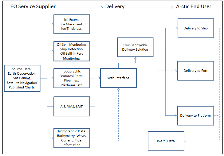
The innovative aspect of the Arctic IAP project is in the near real-time (where applicable) integration of a range of space derived situational awareness data services including oil slick detection from radar and AIS ship tracking. The integrated service will deliver selected Geo-Information layers such as weather, met ocean, AIS, ice extent/movement, oil slick locations to a variety of users in the Arctic on a user friendly platform.
The key innovative concepts are:
Integration of diverse geo-information layers to provide a better operational picture.
Construction of a relational geo-information database facilitating environmental baseline monitoring and automated hazard reporting.
Unique delivery of mission critical geo-information data over extremely low bandwidths (i.e. Iridium) in the High North.
Fast Integrated Situational Awareness Service
Enhanced operational effectiveness, safety and environmental protection through the provision of a fast Integrated Situational Awareness Service using space derived data and integrating it with other information sources and delivered through low bandwidth satellite communications rapidly and directly to the point of need. The user community being and not exclusive to, Arctic oil and gas, shipping, tourism and fishing.
Arctic IAP system
The Arctic IAP system presents a viable Arctic Integrated Situational Awareness Service building upon existing operational or semi-operational services provided by consortium members, and adding additional features believed to be of value to the user community that will help to differentiate and ensure the success of the service.
The proof of concept system brings together the following elements:
Geo-information products (vessel / tracking products; ice edge indication and ice movement assessment), hydrographic products and AIS assets.
We-hosted provision of geo-information products
AnsuR ASIGN optismisation technology to support the user link to a geo-information server (technology reported separately on the EARSC portal under ‘UAV ASIGN for near-real time oil-pipe monitoring). ASIGN delivers large data files over low bandwidth communications links, its novel use in the arctic is being supported by Iridium and Inmarsat.
Iridium Satellite communications link
Deployed Iridium user terminal
Client software on a vessel for access to delivered services
GNSS-based tagging of in-situ observations / images for delivery to the Geo information web server.
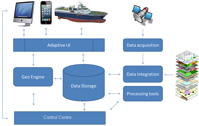
Figure. Components of Integrated Situational Awareness Service chain
This page has no comments.