Image Source: CLS
Product Description
This product estimates offshore extractable wind power at turbine hub height using synthetic aperture radar (SAR) data. The SAR data is capable of providing wind power maps with much higher levels of detail than those derived from numerical models, particularly in coastal areas where the wind speed coastal gradient can be resolved. This product has been implemented in a recent project off the South of France (see below for further information).
Input Data Sources
• Sentinel-1
• TerraSAR-X
• Additional data: Numerical weather models, in-situ buoy networks, profiling LiDAR data.
Required Processing
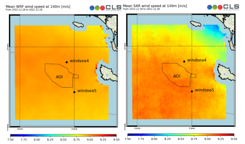
SAR Level-1 products are processed into Level-2 surface wind products using geophysical model functions (GMFs), and these wind speeds are then extrapolated to turbine hub heights. The GMF used will depend on the specific SAR satellite data used. The surface wind speeds can be corrected for systematic errors using in-situ buoy data where available. Meteorological parameters from numerical models can be used with a machine learning model to perform the extrapolation to hub height. This requires LiDAR measurements for training.
The wind speed Weibull parameters are estimated and the extractable power can be computed by simulating a turbine. Errors due to SAR irregular sampling can mitigated by precisely simulating all of the satellites’ passages over the numerical model outputs: for each pixel of the study areas, the mean wind speed produced by numerical can be computed and compared to the mean wind speed seen by the satellites. The difference can be used to correct SAR mean wind speed.
Filtering for bright targets in the SAR may be required since this can negatively impact the accuracy of this product.
Coverage and Frequency
• Coverage: Global
• Frequency:
- • Sentinel-1: 6-12 days
- • TerraSAR-X: 11 days
Resolutions
• Spatial resolution depends on the input satellite data and any resampling steps applied during processing:
• Sentinel-1: ~ 10 m
- • TerraSAR-X: ~ 1 m
Accuracy and Validations
Validation and accuracy depend on location and the availability and quality of in-situ buoy and LiDAR measurements.
Limitations
• Although there is evidence that SAR data can capture the intraday variability in wind speeds in the North Sea, this may not be the case in areas where thermal winds are stronger.
• LiDAR profiles in similar conditions to the area of interest are required.
Delivery Format
• Standard GIS formats.
• User interface
• API
Accessibility and Cost
Costs will depend on the specific user requirements.
Case Study Examples
CLS Contract with the French Ministry of Ecological Transition
In 2022, Collecte Localisation Satellites (CLS) announced a contract for the South of Brittany bidding zone (AO5) with the French Ministry of Ecological Transition’s Directorate General for Energy and Climate (DGEC). This is for the first French wind farm using floating technology and will have a 250 MW capacity. The role of CLS is in the de-risking of the project by providing a precise estimation of the available wind resource. See https://www.cls.fr/en/offshore-wind-new-contract-with-french-ministry-of-ecological-transition/ for further details.
This page has no comments.