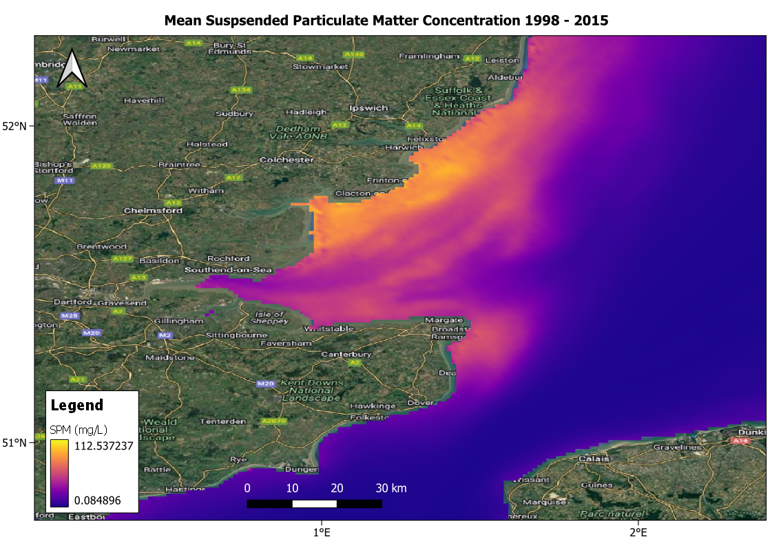
Data source: CEFAS
Product Description
Offshore wind developers require an understanding of the baseline conditions of the coastal areas in which they will conduct activities. On one hand, to ensure the location is suitable for development, and on the other to ensure the development will not contribute to the destruction of the natural landscape. Suspended particulate matter (SPM) measurements give an indication of sediment transport dynamics of an area.
Assessing SPM concentrations using in-situ measurement techniques introduces significant challenges in logistics and planning. These can be mitigated through the use of remote sensing. Both low and high spatial resolution satellite sensors can be used for this. Low spatial resolution sensors, such as MODIS on the Aqua and Terra satellites, VIIRS on Suomi-NPP, and OLCI on the Sentinel-3 satellite, have the ability to capture spectral signatures of SPM due to abundance of bands. They are limited, however, in their ability to capture information for areas very close to the coast. On the other hand, high resolutions satellite data from Sentinel-2 and Landsat can capture finer details, but their spectral resolution reduces their capacity to capture SPM accurately.
Techniques for determining SPM from satellite data include, empirical, semi-empirical and machine learning techniques. These techniques may be applied on a local or global scale and may involve the combination data from multiple satellite platforms.
Input Data Sources
• Low spatial resolution:
- • Sentinel-3
- • Aqua/Terra
- • Suomi NPP
• High resolution:
- • Sentinel-2
- • Landsat-8/9
Required Processing
The following is an example of a typical processing chain to derive SPM from satellite data:
- • Level-1 top of the atmosphere reflectance data is resampled and corrected for glint.
- • Land and water masks are applied to constrain data to the coastal zone.
- • Level-2 data is derived via pixel identification and atmospheric correction algorithms. Automated switching algorithms suited to various water conditions are applied to the remote sensing reflectance to derive SPM.
- • Identification of invalid pixels due to clouds, shadow, ice, vegetation.
- • Further resampling to a target grid.
Coverage and Frequency
• Coverage: Global
• Frequency:
- • Sentinel-2: 6 days
- • Landsat-8: 16 days
- • MODIS: 1 – 2 days
Resolutions
• Low resolution:
- • Sentinel-3: 300 m
- • MODIS: 1 km
• High resolution:
- • Sentinel-2: 10 – 60 m
- • Landsat: 30 – 100 m
• Very-high resolution:
- • Pleiades: ~ 1 m
Accuracy and Validations
SPM retrieved from satellite data is usually validated with in-situ sources such as from sensors mounted on buoys.
Limitations
• The identification of erroneous pixels can result in some bad pixels unintentionally remaining in the final dataset as well as some good pixels being unintentionally removed.
• Validation data does not exist in all areas of interest and so caution should be taken when using data in these areas.
Delivery Format
• NetCDF-4
• GeoTIFF
Accessibility and Cost
• Data from Sentinel, Landsat and Aqua/Terra satellites is freely available through ESA and NASA.
• Free SPM products also exist that use data from some of these missions: see https://data.marine.copernicus.eu/viewer/expert?view=dataset&dataset=OCEANCOLOUR_NWS_BGC_HR_L3_NRT_009_203 and Cefas Data Portal.
Case Study Examples
Arklow Bank Wind Park Phase 2
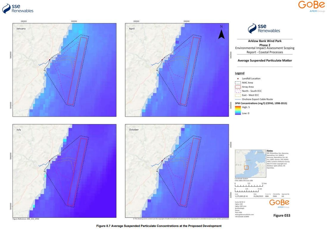
The Environmental Impact Assessment (EIA) Scoping Report for Arklow Bank Wind Park 2 in Ireland was completed in June 2023. It was prepared by GoBe Consultants Limited and approved by SSE Renewables. The purpose of this scoping report was to set out the baseline data sources and methodologies that will inform the EIA, and to allow stakeholders to engage with this information. As part of the activities to understand the baseline coastal environment of the study area, a characterization of the suspended sediments and their temporal distribution is required. The SPM Product ( Cefas Data Portal) distributed by CEFAS allowed for the estimation that the average SPM for the period 1998-2015 is less than 2.5 mg/L with higher levels more likely in during winter.
Moray West Offshore Wind Farm
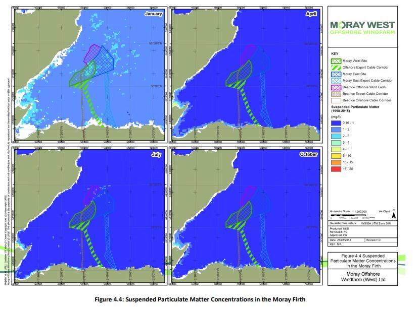
In a similar example to the Arklow Bank case above, the Moray West draft Environmental Management Plan refers to the same SPM product for identification of baseline physical processes. Using monthly means, the document finds that “SPM readings are very low (< ~5 mg/L) throughout the year and are at their highest in winter months”. It is also inferred from this data through comparison with numerical model output that turbidity is low in the area.
This page has no comments.