Description (Source: CropSAR VITO) | ||||||||||
Category | ||||||||||
PRODUCT DESCRIPTION | ||||||||||
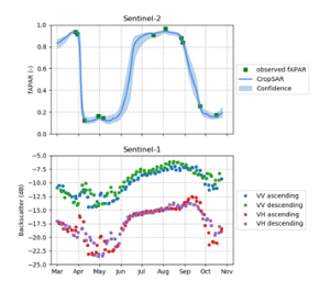
Optical sensors of high-resolution imagery such as Sentinel-2 are unable to look through clouds, resulting in cloud-induced gaps in observations, and hence making it impossible to retrieve the complete time series of a vegetation index. Typically gap-filling (e.g. linear interpolation) and/or smoothing procedures are used to reconstruct continuous growing curves on the available EO data. While this method provides reasonable results for dense time series such as provided by low resolution imagery, much less reliability is observed on the irregular observations from high resolution optical data (from e.g. Sentinel-2). Recent technologies such as CropSAR*, overcome this problem by taking advantage of the combined strength of optical Sentinel-2 data and the cloud-penetrating capacities of radar Sentinel-1 data. * https://blog.vito.be/remotesensing/cropsar2019 | ||||||||||
PRODUCT SPECIFICATIONS | ||||||||||
Main processing stepsBoth datasets are fused in a deep learning framework resulting in Sentinel-2 like time series of vegetation parameters which are free of clouds, using the original Sentinel-2 and Sentinel-1 data. | ||||||||||
Input data sourcesOptical: Sentinel-2 Radar: Sentinel-1 Supporting data: Parcel boundaries | ||||||||||
Spatial resolution and coverageSpatial resolution: Field level Coverage: Global Availability: globally available | ||||||||||
Accuracy / constraintsThematic accuracy: Most mature over European cropland Spatial accuracy: one pixel | ||||||||||
LimitationsPerformance is crop type and crop stage dependent | ||||||||||
Frequency / timelinessFrequency: 3 days Timeliness: near real-time | ||||||||||
Delivery / output formatData type: 1-D time series of FAPAR & associated uncertainties File format: array or CSV | ||||||||||
AccessibilityCommercially available on demand from EO service providers. | ||||||||||
CHALLENGES ADDRESSED - USE CASE(S) | ||||||||||
| Consistent data to address challenges in all business processes | ||||||||||

Overview
Community Forums
Content Tools
This page has no comments.