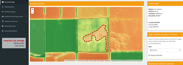
Crop Damage Assessment Tool (Source: GeoVille) | ||||||||||
Category | ||||||||||
PRODUCT DESCRIPTION | ||||||||||
On the one hand crop production is affected by a number of abiotic factors including soil type, its acidity and salinity, thermal and precipitation effects, application of various agricultural inputs as they affect all metabolic activities of the plant. One the other hand, crop production can also be affected by various weather events such as storm, flood, hail, drought, frost, etc. This service will provide a mechanism for verifying crop damages through EO data at field scale and significantly contribute to efficient underwriting, loss adjustment and further claims handling. Crop damage zones details provided by the EO brings more efficiency and precision, especially for underwriting and loss adjustment purposes. Underwriters may prioritize the areas and allocation of human resources while loss adjusters may save time on crop survey and make more precise estimations of actual damage occurred at a given field. | ||||||||||
PRODUCT SPECIFICATIONS | ||||||||||
Main processing stepsThe methodology is based on the use of time series of vegetation indices (e.g. FAPAR – Fraction of Absorbed Photosynthetically Active Radiation, NDVI – Normalized Differenced Vegetation Index or LAI – Leaf Area Index). Changes and anomalies within a defined area and over a period of time are then analysed to identify the zones where a damage has occurred using statistical thresholding. | ||||||||||
Input data sourcesOptical: Sentinel-2, VHR depending on availability (e.g., Planet, Pleiades, Worldview 3&4, RapidEye, SPOT 6&7) Radar: Sentinel-1 Supporting data: Meteorological data (temperature, precipitation, wind, hail), field parcel information such as LPIS | ||||||||||
Spatial resolution and coverageSpatial resolution: HR solution - 10m; VHR and HHR solutions (on demand) - 0,3 – 5m Coverage: Field Level (micro) Availability: globally available | ||||||||||
Accuracy / constraintsThematic accuracy: 85 % Spatial accuracy: 1,5 -2 pixel of input data | ||||||||||
LimitationsTo identify a reason of damage and to disentangle insured damages from mismanagement practices, additional weather data is needed. | ||||||||||
Frequency / timelinessFrequency: various time steps starting from daily observations Timeliness: near real-time for early damage detection | ||||||||||
Delivery / output formatData type: Vector; Raster; API (depending on customer needs) File format: GeoTIFF, shapefile, others on request (depending on customer needs) | ||||||||||
AccessibilityCommercially available on demand from EO service providers. | ||||||||||
CHALLENGES ADDRESSED - USE CASE(S) | ||||||||||
Product Development
Underwriting
Loss Adjustment
Claims Handling
| ||||||||||

Overview
Community Forums
Content Tools
This page has no comments.