You are viewing an old version of this page. View the current version.
Compare with Current
View Page History
Version 1
Next »
Download Product Sheet
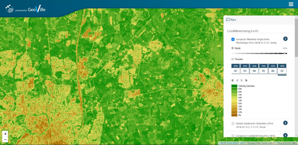
Monthly vegetation phenology (Source: landmonitoring.earth by GeoVille) |
Category |
| | | | |
PRODUCT DESCRIPTION |
Monitoring the vegetation provides an important information on crop’s development and performance of fields. Information on the vegetation status and possible deviations at certain fields is important to identify the problem areas throughout the entire insurance season so that the farmer can react with application of necessary agricultural production technology and inputs to ensure the lesser effects of possible vegetation change in time, to ensure crop’s optimal growth and yielding capacity. Vegetation growth monitoring service allows better precision in underwriting and loss adjustment. |
PRODUCT SPECIFICATIONS |
Main processing stepsEO methods to monitor the growth status is based on optical satellite imagery. With the analysis of vegetation indices such as the Leaf Area Index (LAI). The LAI is an indicator of the canopy structure. It therefore provides a measurement for the biomass on a field and the crop growth. |
Optical: Sentinel-2 Radar: n.a. Supporting data: n.a. |
Spatial resolution and coverageSpatial resolution: 10m Coverage: Regional/national level Availability: globally available |
Accuracy / constraintsThematic accuracy: > 85 % Spatial accuracy: 1,5 – 2 pixels of input data resolution |
LimitationsTimes series of optical data are prone to cloud coverage and thus have limited observational capacity in some regions. |
Frequency / timelinessFrequency: various time steps, starting from daily Timeliness:Near real-time |
Data type: GIS-ready data formats; Raster; API (depending on customer needs) File format: GeoTIFF |
AccessibilityCommercially available on demand from EO service providers. In the future such information will also be made available by Copernicus: https://land.copernicus.eu/user-corner/technical-library/phenology |
CHALLENGES ADDRESSED - USE CASE(S) |
Product Development: - Market analysis
- Index insurance: Toolbox for indices
- Index insurance: Risk / crop modelling (Correlation of EO data with in-situ data)
- Index insurance: Relation between weather events and impact on crop productivity
- Index insurance: Functionalities of plants, chemical reactions, early stress detection
- Index insurance: Parcel/Field and regional yield statistics
- Index insurance: platform for crop health products
- Elaboration of crop profile: Field crops, vegetables, horticulture, greenhouses
- Information on forest health and production at different temporal scales (realtime monitoring, historical development)
- Identification of specific stresses and vegetation problems and their underlying causes
- Risk exposure (product design and customer communication)
Product Sales: - Client outreach
- Pre-contractual consulting (show-case risk exposure)
- Greater acceptance of index covers by farmers
- Regular market penetration review
- Risk alerts
Underwriting: - Seasonal portfolio monitoring
- Online platforms or easy-to-use interfaces integrating various data sources (e.g. vegetation stress, field boundary changes, comparison, etc.)
- Risk / crop zoning
- Actual crop health (vegetation)
- Global/Regional production trends (e.g. monitoring specific crop acreages of surrounding regions/countries)
- Procure better reinsurance terms/capacity from enhanced insurance practice
- Identification of vegetation stages (identify most sensitive stages when crop is the most vulnerable to a risk, e.g. flowering stage)
- Crop calendar and practices
- Regular assessment of risk pricing and product rating
Loss Adjustment: - Workforce allocation and planning
- Benchmark physical field observations against yield loss detection (e.g. product calibration)
- Risk-mapping against crop’s vegetation stages
- Increase credibility of loss adjustment (e.g. show EO data/visualization to support loss adjustment communication to farmer)
- Enhance field survey (better precision with EO data support)
- Detect crop damage at field level
- Assess crop damage at field level
- Distinct field heterogeneity with crop damage
Claims Handling: - Identification of actual damage size (tons (volume) / ha (area) / price (yield value))
- Quality control assessment of claims before pay-out
- Fraud detection
- Obtaining timely, reliable and consistent data to speed-up the indemnity pay-outs
|

This page has no comments.