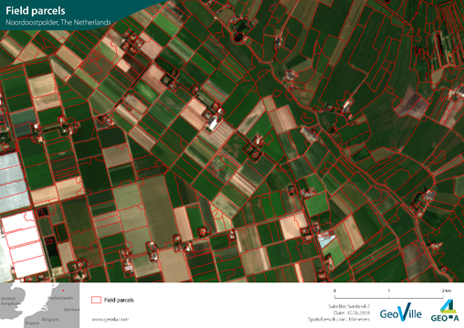
Field parcels detected in Emmeloord, The Netherlands (Source: GeoVille) | ||||||||||
Category | ||||||||||
|
|
|
|
| ||||||
PRODUCT DESCRIPTION | ||||||||||
Information on field boundaries is highly important, especially in data sparse regions such as emerging markets. This service identifies agricultural field parcels within a selected area of interest. The detection of field parcels is based on their distinct management histories. Furthermore, this data can be used as input for other satellite-derived information such as crop type detection, growth monitoring or crop health and more accurate assessment of the area and parts of fields damaged. | ||||||||||
PRODUCT SPECIFICATIONS | ||||||||||
Main processing stepsAnalysis is based on satellite imagery using time-series and growing patterns to delineate the individual field parcels. Image segmentation is performed based on vegetation indices (such as NDVI) to detect differences between neighbouring fields. To ensure better accuracy, the segmentation sensitivity and time-frame selection can be adapted to account for regional differences. | ||||||||||
Input data sourcesOptical: Sentinel-2, VHR Radar: Sentinel-1 Supporting data: n.a. | ||||||||||
Spatial resolution and coverageSpatial resolution: field level Coverage: Regional/national level Availability: globally available | ||||||||||
Accuracy / constraintsThematic accuracy: > 85 %, within-season retrieval depending on weather conditions Spatial accuracy: 1.5 - 2 pixels of input data | ||||||||||
LimitationsThe detection of large fields can be challenging. To account for regional field variances, time-frame selection and segmentation sensitivity can be adapted. | ||||||||||
Frequency / timelinessFrequency: upon request – across growing season, within-season, annual, multi-annual Timeliness: near real-time | ||||||||||
Delivery / output formatData type: GIS-ready data formats; Vector; API (depending on customer needs) File format: Shapefile | ||||||||||
AccessibilityCommercially available on demand from EO service providers. | ||||||||||
CHALLENGES ADDRESSED - USE CASE(S) | ||||||||||
Product Development:
Product Sales:
Underwriting:
Loss Adjustment:
Claims Handling:
| ||||||||||

Overview
Community Forums
Content Tools
This page has no comments.