| Name
|
Size
|
Creator |
Creation Date
|
Last Modification Date
|
Labels |
Attached To |
|
PDF File P30 Satellite-derived bathymetry for port and coas… |
59 kB |
Francesco Casaril |
Jan 22, 2024 09:24 |
Jan 22, 2024 09:24 |
|
Page: Satellite-Derived Bathymetry for Port and Coastal Monitoring - gap analysis
|
|
PNG File image-2024-1-22_10-20-18-1.png |
1.04 MB |
Francesco Casaril |
Jan 22, 2024 09:20 |
Jan 22, 2024 09:20 |
|
Page: Satellite-Derived Bathymetry for Port and Coastal Monitoring - capabilities
|
|
PNG File image-2024-1-19_16-4-48-1.png |
954 kB |
Francesco Casaril |
Jan 22, 2024 09:19 |
Jan 22, 2024 09:19 |
|
Page: Satellite-Derived Bathymetry for Port and Coastal Monitoring - capabilities
|
|
PDF File P16 Predicting terrorism hotspots.pdf |
56 kB |
Francesco Casaril |
Jan 19, 2024 15:19 |
Jan 19, 2024 15:19 |
|
Page: Predicting terrorism hotspots - gap analysis -
|
|
PNG File image-2024-1-19_16-4-48-1.png |
954 kB |
Francesco Casaril |
Jan 19, 2024 15:04 |
Jan 19, 2024 15:04 |
|
Page: Predicting Terrorism Hotspots - capabilities
|
|
PDF File P16 Predicting terrorism hotspots.pdf |
56 kB |
Francesco Casaril |
Jan 19, 2024 14:42 |
Jan 19, 2024 14:42 |
|
Page: Predicting Terrorism Hotspots - gap analysis
|
|
PNG File image-2024-1-19_15-35-49-1.png |
954 kB |
Francesco Casaril |
Jan 19, 2024 14:35 |
Jan 19, 2024 14:35 |
|
Page: Predicting Terrorism Hotspots
|
|
PNG File image-2024-1-18_9-51-11-1.png |
950 kB |
Francesco Casaril |
Jan 19, 2024 14:35 |
Jan 19, 2024 14:35 |
|
Page: Predicting Terrorism Hotspots
|
|
PDF File P23 Wildfire danger forecasting (Global Wildfire I… |
64 kB |
Francesco Casaril |
Jan 19, 2024 13:56 |
Jan 19, 2024 13:56 |
|
Page: Wildfires Danger Forecasting (Global Wildfire Information System) - gap analysis
|
|
PNG File image-2024-1-19_14-51-33-1.png |
542 kB |
Francesco Casaril |
Jan 19, 2024 13:51 |
Jan 19, 2024 13:51 |
|
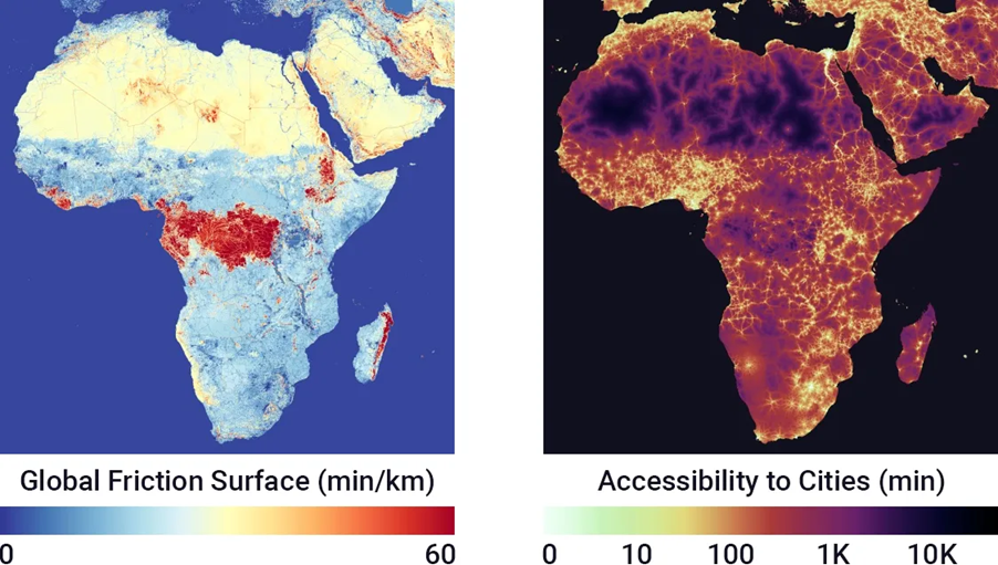
Page: Wildfires Danger Forecasting (Global Wildfire Information System) - capabilities
|
|
PNG File image-2024-1-16_16-35-14-1.png |
682 kB |
Francesco Casaril |
Jan 19, 2024 13:50 |
Jan 19, 2024 13:50 |
|
Page: Wildfires Danger Forecasting (Global Wildfire Information System) - capabilities
|
|
PDF File P25 Identification of trends related to shifts in … |
60 kB |
Francesco Casaril |
Jan 19, 2024 13:41 |
Jan 19, 2024 13:41 |
|
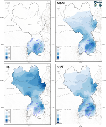
Page: Identification of Trends Related to Shifts in Rainfall Patterns - gap analysis
|
|
PNG File image-2024-1-19_14-38-33-1.png |
221 kB |
Francesco Casaril |
Jan 19, 2024 13:38 |
Jan 19, 2024 13:38 |
|
Page: Identification of Trends Related to Shifts in Rainfall Patterns - capabilities
|
|
PNG File image-2024-1-16_16-35-14-1.png |
682 kB |
Francesco Casaril |
Jan 19, 2024 13:38 |
Jan 19, 2024 13:38 |
|
Page: Identification of Trends Related to Shifts in Rainfall Patterns - capabilities
|
|
PDF File P24 Identification of flood hazard areas.pdf |
63 kB |
Francesco Casaril |
Jan 19, 2024 13:24 |
Jan 19, 2024 13:24 |
|
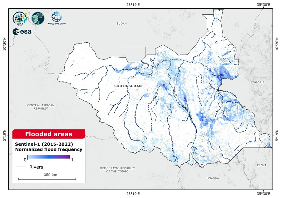
Page: Identification of Flood Hazard Areas - gap analysis
|
|
PNG File image-2024-1-19_14-20-38-1.png |
672 kB |
Francesco Casaril |
Jan 19, 2024 13:20 |
Jan 19, 2024 13:20 |
|
Page: Identification of Flood Hazard Areas - capabilities
|
|
PDF File P29 Heat hazard maps.pdf |
58 kB |
Francesco Casaril |
Jan 19, 2024 13:17 |
Jan 19, 2024 13:17 |
|
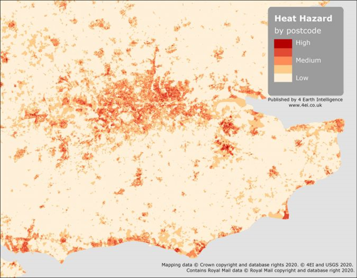
Page: Heat Hazard Maps - gap analysis
|
|
PNG File image-2024-1-19_14-12-54-1.png |
682 kB |
Francesco Casaril |
Jan 19, 2024 13:12 |
Jan 19, 2024 13:12 |
|
Page: Heat Hazard Maps - capabilities
|
|
PNG File image-2024-1-16_16-35-14-1.png |
682 kB |
Francesco Casaril |
Jan 19, 2024 13:12 |
Jan 19, 2024 13:12 |
|
Page: Heat Hazard Maps - capabilities
|
|
PDF File P21 Drought monitoring at the assets level.pdf |
60 kB |
Francesco Casaril |
Jan 19, 2024 13:11 |
Jan 19, 2024 13:11 |
|
Page: Drought monitoring at asset level - gap analysis
|