A service strengthening urban resilience and meeting user needs
| Sponsor | Project | Solution provider | User |
|---|---|---|---|
|
|
| |


Urban development
Smart cities
Urban planners
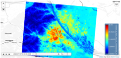
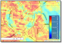
Risk map regarding heat load
The pilot aims to provide climate services for major cities in Austria. Primary users of the service are experts in city administration working on urban development plans, environemental protection and risk managament. The application was developed for the City of Vienna with possibility of extension for other cities in Austria and currently covers Graz, Linz, Klagenfurt, Salzburg and Innsbruck. Dependent on the local governement structure, different departments in the city administration are addressed. For example, in Vienna these are Municipal Department 18 – Urban Development and Urban Planning (MA 18), Municipal Department 22 - Environmental Protection etc. The users mostly have long-year experience in their field of work and are often involved in public relations and provide technical support for decision-makers.

Zentralanstalt für Meteorologie und Geodynamik (ZAMG) offers a broad range of services, from weather forecasts to climate and earthquake monitoring as well as the constant analysis and prediction of atmospheric pollutants.
Our outstanding team collaborates with universities and research institutions around the globe to maintain our high-quality measurement facilities and services.
ZAMG provides state-of the-art in-house supercomputer facilities and powerful databases containing quality-controlled meteorological measurements to calibrate our models and perform ongoing climate change assessments.
ZAMG also represents Austria in major international organizations such as the World Meteorological Organization (WMO) and EUMETNET, a cooperative network of 26 European weather services.
In order to asses user needs and provide a feedback from users regarding the pilot application, in Mai-June 2022 the ZAMG conducted an anonymous online survey among experts from cities involved in the pilot.
The users expressed general appreciation for “valuable data that support urban planning decisions”, but also for “any form of easily understandable information that can be used for political consulting”. The need for information is increasing and “may vary in detail, dependent on the urban planning question or task”.
- Easily understandable information on climate change in cities eg. heat maps, statistics
- Climate data/results preferably avilable on public accessible platform
- Display of data in format of maps/images with possibility of data export
- computational requirements and expert knowledge needed to provide high-resolution climate information
- assessing and communicating uncertanties in input data and model results
- offering easy accesible results with a plug-in visualization
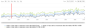
- high-resolution maps of climate indices for different future climate scenarios
- data access through national Climate Change Data Center (CCCA Data Center)
- direct visualization of results with zoom, opacity, time series and export function
Learn more about the service: https://e-shape.egitlab.zamg.ac.at/e-shape/ https://data.ccca.ac.at/group/e-shape-urban-resilience-to-extreme-weather
Learn more about e-shape: www.e-shape.eu
A question? Contact the Helpdesk: https://helpdesk.e-shape.eu
This page has no comments.