Pilot of Earth Observation based phytoplankton biomass on mesotrophic lakes in Estonia
| Sponsor | Project | Solution provider | User |
|---|---|---|---|
|
|  |
|


Marine ecosystem
Coastal
Monitor bodies of inland water
EMÜ priorities in academic and research activities are to foster the sustainable development of natural resources necessary for mankind as well as the preservation of natural heritage and habitats.
The Institute of Agricultural and Environmental Sciences (IAES) unites various fields of agriculture, environmental protection, nature conservation and rural economy. Main research and studies for limnology are carried out in our Centre for Limnology (CL) on the shore of the large Lake Võrtsjärv.
CL is responsible for Estonian inland water research and state monitoring. CL is an adviser of Estonian Ministry of the Environment in case of implementation of European Water Framework Directive.
Using knowledge about how certain substances, such as one of the main pigments of the phytoplankton (Chlorophyll a - Chl a) alter the colour of the water, these parameters can be derived from optial Earth Observation (EO) satellite sensors.
Water Insight provides monitoring services of Chl a based on EO data which is validated with in situmeasurements. Also the maps of WFD phytoplankton biomass status classes are created, by application of the WFD tresholds on Chl a as a proxy for phytoplankton biomass.
The maps are made available in a portal, which allows to follow the lakes in time, zoom and download maps and time series.
“It is good to see that even in clear water lakes the variation in Chl a concentrations can be picked up with satellite EO data. This makes it possible to more regularly monitor the under-sampled clear lakes in Estonia.” Alo Laas, EMÜ
Estonia is one of the EU countries where most lakes are still in their natural state, either eutrophic with high Chl aconcentrations, or mesotrophic, with low Chl a concentrations. Limited in resources, most of the state monitoring effort goes to the largest lakes, and only some small lakes, which were chosen based on their importance and the chances of passing WFD thresholds. However, it is important to monitor also the lakes with ‘good’ status.
Although being inland waters, the clear water lakes need a different method to derive Chl a from EO data compared to turbid lakes. For clear lakes the method is more similar to sea monitoring with regard to retrieval of Chl a from satellite EO. Another issue that needs to be taken into account when deriving Chl a from EO data in these clear lakes is bottom visibilty. Cloud cover sometimes hampers the retrieval of parameters from optical satellites, however, for under-sampled lakes the availability of satellite EO data is still enough to increase the monitoring frequency.
Water managers (combined: EMÜ and others) appreciate the maps for:
· cheap and automated monitoring for under-sampled lakes, combined with targeted sampling in case of unexpected changes
· systems analysis, for which the spatial component is key
· evaluation of the spatial effect of measures taken to improve water quality for the WFD as input for spatial ecological models
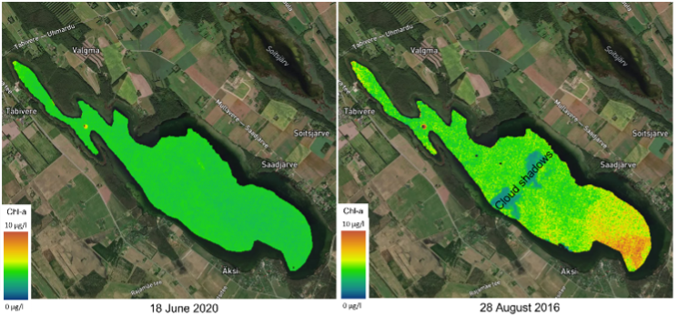
Figure 1 Satellite-based EO maps confirm that Saadjärv is usually a lake with low Chl a concentrations over the whole surface (example from June 18th 2020). Still, sometimes slightly elevated concentrations of Chl a can be detected in a spatial pattern (example from 28th August 2016).
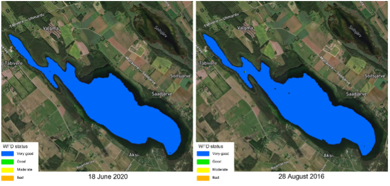
Figure 2 Satellite-based WFD classification maps based on satellite EO Chl a concentrations. Although for most of the times lake WFD class is ‘very good’, for a few pixels the class changed from ‘very good’ to ‘good’ on 28th August 2016.
Learn more about the service: https://www.waterinsight.nl/projects/e-shape
Learn more about e-shape: www.e-shape.eu
A question? Contact the Helpdesk: https://helpdesk.e-shape.eu
This page has no comments.