Pilot of Earth Observation based phytoplankton biomass on mesotrophic lakes in Estonia
| Sponsor | Project | Solution provider | User |
|---|---|---|---|
|
|  |
|


Marine ecosystem
Coastal
Monitor bodies of inland water
EMÜ priorities in academic and research activities are to foster the sustainable development of natural resources necessary for mankind as well as the preservation of natural heritage and habitats.
The Institute of Agricultural and Environmental Sciences (IAES) unites various fields of agriculture, environmental protection, nature conservation and rural economy. Main research and studies for limnology are carried out in our Centre for Limnology (CL) on the shore of the large Lake Võrtsjärv.
CL is responsible for Estonian inland water research and state monitoring. CL is an adviser of Estonian Ministry of the Environment in case of implementation of European Water Framework Directive.
Using knowledge about how certain substances, such as one of the main pigments of the phytoplankton (Chlorophyll a - Chl a) alter the colour of the water, these parameters can be derived from optial Earth Observation (EO) satellite sensors.
Water Insight provides monitoring services of Chl a based on EO data which is validated with in situmeasurements. Also the maps of WFD phytoplankton biomass status classes are created, by application of the WFD tresholds on Chl a as a proxy for phytoplankton biomass.
The maps are made available in a portal, which allows to follow the lakes in time, zoom and download maps and time series.
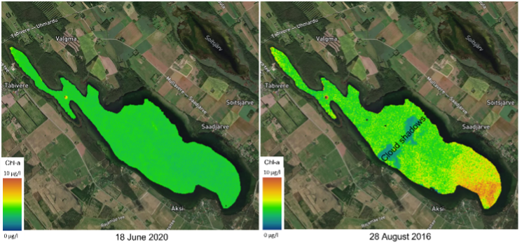
“It is good to see that even in clear water lakes the variation in Chl a concentrations can be picked up with satellite EO data. This makes it possible to more regularly monitor the under-sampled clear lakes in Estonia.” Alo Laas, EMÜ
- Estonia is one of the EU countries where most lakes are still in their natural state, either eutrophic with high Chl aconcentrations, or mesotrophic, with low Chl a concentrations.
- Limited in resources, most of the state monitoring effort goes to the largest lakes, and only some small lakes, which were chosen based on their importance and the chances of passing WFD thresholds. However, it is important to monitor also the lakes with ‘good’ status.
- Users from the wind energy industry inquire about the trustworthiness of EO-based wind data.
- Users from the wind energy industry are not so fmailiar with EO data sets and require that data is easy accesses and use and that any uncertainties related to the data layers are well documented.
Users can browse DTU's archive with 300,000+ wind maps over the Europea seas and other selected areas with importance for offshore wind energy planning.
- Users can download wind fields over an area of interest (e.g a future offshore wind farm site) and investigate the wind flow in detail.
- Users can view and download different wind atlases based on EO data or model simulations and use there for their own analyses and presentations.

Wind map retrieved over the German Bight on June 6, 2019. Winds are from the southeast and lee effects of several offshore wind farms in the area can be seen.
Learn more about the service: https://science.globalwindatlas.info/ (select ‘European offshore wind atlas’ or ‘Offshore winds fields in near-real-time’ to see the EO based data sets)
Learn more about e-shape: www.e-shape.eu
A question? Contact the Helpdesk: https://helpdesk.e-shape.eu
This page has no comments.