| Section |
|---|
Assess forest damage
| Column |
|---|
| 
|
| Column |
|---|
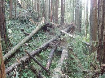
| Forests related ecological services and economic functions can suffer from storms and insect infestations. In a future climate many of the current threats to European forests can be expected to increase, including storms, invasive alien species and insect damage (1). The availability of integrated remote sensing and geographical data represents an efficient way to record and analyse such damages and to provide public authorities with the needed information to face them. It is important to take preventive actions and effective countermeasures with the objectives of sustainable forest management, wood market stabilisation and disaster management planning. |
|
The frequency and magnitude of storms lead in the past decades to several millions Euro forest area losses. The responsible agenies need fast reliable infomration about damages to react quickly and efficiency and direct forest management activities. Optical and radar satellites together with laser scanning technology offer cost-effective and timely information on forest structure and damage, as demonstrated by the EUFODOS project with the GMES/Copernicus High Resolution Forest Core Layer (2). Among the products of this service, map information is produced focusing on the derivation of windfall areas and displaying damaged forest areas.
References (1) European forests — ecosystem conditions and sustainable use, EEA 2008. (2) http http://www.eufodos.info/ |