| Section |
|---|
| Column |
|---|
| Fires are naturally occurring disturbances and many species even require fires for regeneration. However, climate change, deliberately ignited fires and poor forest management are cause to a continuous increase, extent and severity of fires globally. These excessive fires adversely affect various parameters such as water quality, air quality, soil properties, nutrient cycling, and vegetation and cause danger to humans and wildlife. The effects of fires can vary significantly since they depend on site characteristics and fire behaviour. Knowledge and understanding of fire dynamics and effects is very important and monitoring of fires is essential to meet resource and ecosystem management goals. Satellite remote sensing proves to be very valuable in the forecasting and monitoring of fires. |
| Column |
|---|
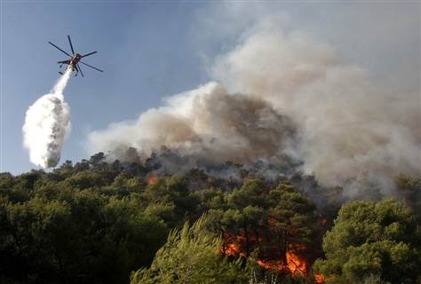
A firefighting helicopter drops water on a forest fire in Nea Makri village, northeast of Athens, Greece, 2009. Credit: Yiorgos Karahalis, Reuters |
|
Fire produces different types of spectral signals observable from space including direct radiation from the flame front (heat & light), aerosols (smoke), solid residue (char & ash) and altered vegetation structure (scar). Analysis of active fires depends on the short lived thermal signal, while burned area analysis is based on the detection of char and scar signals which display longer lasting spectral signals. The spectral signal from charcoal deposition is quite specific but relatively short lived because the charcoal may be attenuated by the wind or washed out by the rain. The scar signal is more persistent but less specific since it can be confused with vegetation removal resulting from for example harvesting, grazing or defoliation by pathogenic agents. In the visible spectrum charcoal may be confused with dense dark vegetation, water, dark soils, wetlands, cloud and terrain shadows. The near infrared (NIR) has proven to be the best spectral region to discriminate between burned areas and other surfaces. | Section |
|---|
| Column |
|---|
| 
|
| Column |
|---|
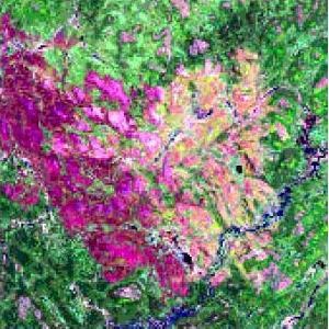
Satellite remote sensing makes it possible to monitor fires globally in near-real time. The dynamic process of fires extending over large, inaccessible areas, can be readily observed from various satellite sensors such as (A)ATSR, Landsat, AVHRR, MODIS and SPOT. Remote sensing of burned areas is limited by various factors such as target variability, spectral separability, cloud formation, smoke, vegetation canopy and understory fires. Burn scars can be observed if the fire was severe and recent enough and if the canopy is open enough. Monitoring at large scales provides information about ecological processes such as carbon storage and nutrient budgets. In a fire regime with large contiguous burn scars it is possible to obtain very accurate classification results, even at coarse spatial resolution, if the classification algorithm is good. More detailed observation by high resolution sensors provide more detail on the intensity and spatial configuration of fires. Landsat TM image showing a recent fire event in a boreal forest. Dark magenta depicts the highest-severity fire. Lighter shades of magenta, to pink, to yellow, and finally to green depict a decreasing level of fire severity. Credit: Conservation Biology Institute |
|
Forest fires in Europe are monitored by the European Forest Fire Information System (EFFIS), a system established by the JRC’s institute IES (Institute for Environment and Sustainability) and the European Commission's Directorate General for Environment. EFFIS provides information on fires, occurring in Europe, in support to forest fire-fighting services and other organizations such as the Commission's Monitoring and Information Centre (MIC). NASA’s Fire Information for Resource Management System (FIRMS) integrates remote sensing and GIS technologies to deliver global MODIS hotspot/fire locations and burned area information to natural resource managers and other stakeholders around the World. ESA has developed the ATSR World Fire Atlas which is a multi year atlas of 80,000 images per year, including all Hot Spots (including gas flares). It is coordinated and validated by the Data and Information System of the International Geosphere Biosphere Programme (IGBP-DIS). Other institutions involved in remote sensing of fires to achieve sustainable management of forests and enhancement of forest carbon stocks include the United Nations, IPCC, EEA, NOAA, and FAO. References: ESA 2013, Earth Observation for Green Growth: An overview of European and Canadian Industrial Capability |