| Content Column |
|---|
| tabbed-blocks | true |
|---|
| id | 353381020 |
|---|
| | Content Block |
|---|
| name | Applications |
|---|
| id | 353380946 |
|---|
| | Section |
|---|
| Column |
|---|
| Earthquakes Each year thousands of earthquakes occur throughout the world. With the increasing global population and infrastructure the consequences of earthquakes are ever more devastating. A substantial amount of the yearly occurring earthquakes are over magnitude 5 on the Richter scale and cause maps to be suddenly outdated, posing additional challenges to rescue workers on the ground. Earth observation satellites have proven to be of great help to rescue efforts by providing updated views of how the landscape and infrastructure have been affected. Satellite remote sensing enables measurements of even small changes in the earth surface which can be used as an indication to indicate the likelihood of an earthquake event. |
| Column |
|---|
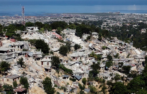
Haïti earthquake 2010. Credit: REUTERS/Eduardo Munoz
|
|
Satellite imagery can complement the information collected on the ground. It can be used to detect fires and derive up-to-date land cover maps. To meet the requirements of rescue workers very high resolution remote sensing from optical and radar satellites is required. Satellite imagery acquired immediately after the event can be used to create emergency maps. When compared to situation maps generated from archived satellite data before the hazard, major changes and possible passage routes for relief and rescue workers can be identified. Satellite data used to forecast and manage earthquakes are primarily derived from Synthetic Aperture Radar (SAR) instruments. When certain weather conditions such as cloud formations prevail, the use of radar satellites is recommended as opposed to optical satellites. Radar satellites are able to peer through the clouds and can be used to identify hazards such as earthquakes/ map surface deformations caused by earthquakes. A modern technique called SAR Interferometry (inSAR) has been developed and widely used to measure dislocation extent from the source of an earthquake. InSAR involves the comparison of two or more radar images of the same location over time to precisely measure changes of ground motion between different image acquisitions. The resulting coloured interferograms usually appear as rainbow fringe patterns. A very promising technique in the field of volcano and earthquake detection and management is POLinSAR (SAR Polarimetry and Polarimetric Interferometry). | Section |
|---|
| Column |
|---|
| 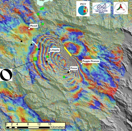
L'Aquila earthquake: Envisat interferogram. Credit: ESA
|
| Column |
|---|
In 2000 the European and French space agencies (ESA and CNES), together with the Canadian Space Agency (CSA founded the International Charter, which aims at providing satellite data free of charge to those affected by disasters anywhere in the world. Through the Charter people from all over the world can benefit from information generated by multiple satellite sensors such as Japan’s ALOS, CNES’s SPOT, the U.S.’s WorldView and QuickBird, Canada’s RADARSAT and ESA’s ERS, Envisat and future Sentinels. Following the 6.3 earthquake that shook the medieval town of L’Aquila in central Italy on 6 April 2009, satellite radar data from ESA’s Envisat and the Italian Space Agency’s COSMO-SkyMed, have been used to generate interferograms. The COSMO-SkyMed constellation consists of multiple satellites which allows for frequent data acquisition. Consequently interferograms can be calculated every few days. The COSMO-SkyMed and Envisat have provided a dense sampling of the ground deformation around the L’Aquila area. The Envisat interferogram has reveiled a maximum displacement area of as much as 25 cm located midway between L’Aquila and Fossa. |
|
Globally there are a number of organizations involved in remote sensing earthquakes. The International Charter for example has 10 members: Canadian Space Agency (CSA), the Indian Space Research Organisation (ISRO), the US National Oceanic and Atmospheric Administration (NOAA), the Argentine Space Agency (CONAE), the Japan Aerospace Exploration Agency (JAXA), the British National Space Centre/Disaster Monitoring Constellation (BNSC/DMC), the U.S. Geological Survey (USGS) and the China National Space Administration (CNSA). Other institutions and programs addressing earthquake phenomena include the UN, GMES, The Consortium of Organization for Strong-Motion Observation Systems (COSMOS), European Centre on Prevention and Forecasting of Earthquakes (ECPFE), The European Plate Observing System (EPOS). |
| Content Block |
|---|
| | Advanced Tables - Table Plus |
|---|
| columnAttributes | style="width:120px;",style="width:120px;",style="width:300px;",style="width:300px;",style="width:180px;" |
|---|
| Products | Ext. Source | Descriptions | Product Standards | Ref. Project |
|---|
1) geographic reference: features derived from the themes: hydrology, transport, population, industry and utilities, physiography and land cover.
2) pre-disaster situation: these products should provide relevant and up-to-date thematic information that can help civil protection organisations during crises and the latter for the emergency plans. |
| Preparedness / prevention:
geographic ref: - Hydrology: rivers, lakes, reservoirs and open water.
- Transport: All transport networks and related infrastructure (e.g. roads, tracks, trails, railways, bridges, harbours, airfields)
- Population: All populated areas and associated features. Toponyms and administrative boundaries.
- Industry and utilities: industrial installations and power stations.
- Physiography: cliffs, contours and spot heights.
- Land cover: Built-up areas, housing, cropland, grassland, scrub, trees, bare soil and wetlands. pre-disaster: location of actors and what they do in the operational theatre (who-what- where), road access, climatic conditions, health centres, security zones etc. Landcover, landuse, risk areas/analysis, environmental or vulnerability information can be shown as well.
| GMES Emergency Management Service Portfolio (SAFER) | SAFER | 1) disaster extend
2) damage assesment |
| Emergency reponse: (1) extend, location, timing, urban areas, tranport, key infrastructures... (2) type of damage |
| SAFER
(Respond, Preview, Risk-EOS) |
|
|
| Content Block |
|---|
| name | Success Stories |
|---|
| id | 353380983 |
|---|
| | Advanced Tables - Table Plus |
|---|
| columnAttributes | style="width:200px;",style="width:200px;",style="width:200px;",style="width:200px;" |
|---|
| |
|
| Content Block |
|---|
| name | References |
|---|
| id | 353381001 |
|---|
| | Advanced Tables - Table Plus |
|---|
| columnAttributes | style="width:250px;",style="width:600px;",style="width:150px;",style="width:100px;" |
|---|
| Topic | Description | Keywords | Reference |
|---|
| | | |
|
|
|
|
