| Section |
|---|
| Column |
|---|
| Air quality Air quality refers to the atmospheric composition of gases and particulates near the Earth's surface. This composition is determined by local emissions of substances such as ozone, aerosols, and the ozone precursors NOx and volatile organic compounds, and is highly variable in space and time. High concentrations of pollutants have adverse effects on the air quality worldwide; air pollution is increasingly affecting our planet, causing premature deaths of humans and damaging flora and fauna. The use of satellite remote sensing to measure environmentally significant pollutant trace gases and aerosols is urgently needed to understand the complex consequences of increasing anthropogenic emissions, the biogenic response to changing temperature and humidity, and the escalating incidence of fire. |
| Column |
|---|
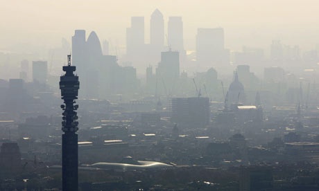
Air pollution hanging over London 2011. Photograph: Mike Hewitt/Getty Images
|
|
The ability to monitor, forecast, and manage air quality has therefore become high priority. Satellite remote sensing of air quality proves to be a vary valuable contribution to ground-based measurements and provides information about a wide range of particulate matter including aerosols, tropospheric O3, tropospheric NO2, CO, HCHO, and SO2. Measurement of air quality by remote sensors is being determined by various parameters such as species measured, horizontal resolution and coverage, temporal resolution and coverage, and vertical resolution including boundary layer observation capability. Trace gas remote sensing is based upon solar backscatter and thermal infrared emission. Satellite remote sensors generate high temporal and spatial resolution data in a cost-effective manner. When combining these to ground-based data from monitoring stations and atmospheric chemistry models, it is possible to generate near-real time and accurate information on air quality which can be used by policy makers to mitigate air pollution and protect public health. Satellite observations with instruments such as MOPITT (NASA’s mission on Measurements of pollution in the troposphere), GOME (ESA’s ultraviolet and visible spectrometer for global monitoring of atmospheric Ozone), MODIS (NASA’s Moderate Resolution Imaging Spectroradiometer), MISR (NASA’s Multi-spectral Imaging Spectroradiometer), SCIAMACHY(ESA’s imaging spectrometer providing global measurements of trace gases in the troposphere and in the stratosphere), MLS (Nasa’s Microwave limb sounder to emotely sense vertical profiles of atmospheric gases, temperature, pressure, and cloud ice), OMI (NASA’s Ozone Monitoring Instrument), AIRS (NASA’s Atmospheric Infrared Sounder) and TES (NASA’s Tropospheric Emission Spectrometer) have demonstrated the value of using satellites for the detection of air pollutants, greenhouse gases and particles such as those from dust, smoke, and pollen extending from regional to global scales. | Section |
|---|
| Column |
|---|
| 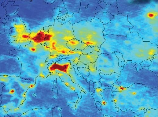
The image shows the mean density of nitrogen dioxide over Europe between January 2003 and June 2004, as measured by the SCIAMACHY instrument on ESA's Envisat satellite. Credit: ESA , University of Heidelberg |
| Column |
|---|
Satellite remote sensing greatly contributes to existing air quality observation and management by providing continuous and global information on build-up, emissions and long-range transport of pollutants, and particles. Assimilation of data from various parameters generated by multiple platforms is being used in analyses and forecasts. For example GOME, SCIAMACHY and OMI have been used to detect NO2 and formaldehyde and to develop constraints on sources of NOx and VOCs. Carbon monoxide observations from MOPITT and AIRS have been used to constrain CO sources and to track intercontinental transport of pollution plumes. TES and MLS have been used to map the continental outflow of ozone pollution while aerosol optical depth (AOD) observations from MODIS and MISR have been used to derive surface air concentrations of aerosols. High-resolution instruments such as the Compact High Resolution Imaging Spectrometer/Project for On-Board Autonomy (CHRIS/PROBA) have both the spectral and spatial sensitivity to accurately retrieve aerosols at a detailed level. |
|
Since it has become clear that human activities are changing the composition of the Earth’s atmosphere, which impacts climate, human health, the balance of ecosystems and the ability of the atmosphere to cleanse itself of harmful pollutants and greenhouse gases, monitoring air quality has become high priority and is part of an international integrated observation network system. Many organizations and programs are involved including WMO, EEA, UNEP, ICSU, NOAA, IGOS-IGACO, GEOSS, and IGOS. ESA’s future Sentinel-4 and -5 missions which are being developed under Europe’s Global Monitoring for Environment and Security (GMES) programme will provide measurements of atmospheric chemistry, contributing to air quality monitoring services throughout Europe. |