
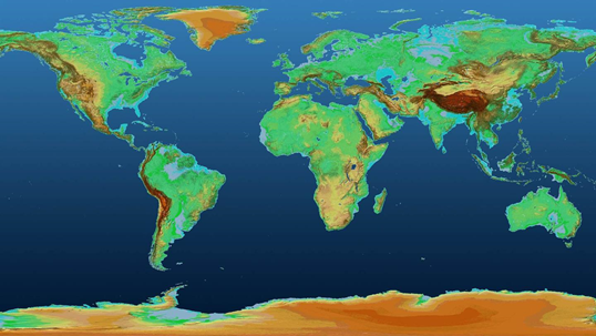
Global TanDEM-X Elevation Model (Source: DLR) | ||||||||||
Category | ||||||||||
PRODUCT DESCRIPTION | ||||||||||
Different ways are currently established to model elevation: The Digital Elevation Model (DEM), the Digital Surface Model (DSM) and the Digital Terrain Model (DTM). Digital Terrain Models capture the ground and picture the bare Earth’s surface as its reference; whereas, Digital Surface Models take into account natural and built surface features such as buildings and trees. Often, these terms are interchangeable; the term DEM is also widely used as a generic definition to describe DSM and DTM. Currently, various data sets are globally available such as the TanDEM-X, SRTM DEM, ASTER GDEM and the ALOS World 3D. Most of them can be obtained at different resolutions. | ||||||||||
PRODUCT SPECIFICATIONS | ||||||||||
Main processing stepsTwo methods are used to derive these types of elevation models. Some models are based on radar data, using InSAR Interferometric synthetic aperture radar data. For these models, two radar images from different sensors that are captured at the same time are used and combined. For models based on optical data, also two optical images from different angles are combined using Ground Control Points to locate the model. | ||||||||||
Input data sourcesOptical: ASTER, SPOT, Pléiades Radar: TanDEM-X, SRTM Supporting data: topographic maps, optical images, etc. | ||||||||||
Spatial resolution and coverageSpatial resolution: 1m – 1km Coverage: global Availability: globally available | ||||||||||
Accuracy / constraintsThematic accuracy: n.a. Spatial accuracy: Copernicus DEM: horizontal and vertical accuracy ranges between max. 6 m | ||||||||||
LimitationsIn densely vegetated areas it is not possible to capture the ground and picture the bare Earth’s surface. For processing with optical satellite imagery, two good quality images from different directions are needed. Cloud cover and shadows are sometimes a limiting factor as well. | ||||||||||
Frequency / timelinessFrequency: depending on satellite revisit rate Timeliness: within a few days | ||||||||||
Delivery / output formatData type: raster formats File format: GeoTIFF | ||||||||||
AccessibilityUsually, models with a coarser resolution are freely available, others must be purchased commercially. As an example, the Copernicus DEM 90 m dataset with global coverage is freely available, the global 30 m dataset as well as the 10 m dataset covering the European area have a restricted access. Also, the ASTER GDEM is available for free at resolution of 30 m. | ||||||||||
CHALLENGES ADDRESSED - USE CASE(S) | ||||||||||
Product Development:
Product Sales:
Underwriting: Loss Adjustment: | ||||||||||
...