Page tree

Versions Compared

Key

  • This line was added.
  • This line was removed.
  • Formatting was changed.


Content Layer
id353386303


Content Column
tabbed-blockstrue
width100.0%
id2047532052


Content Block
nameSummary
id2119714053

Wind maps and wind atlases for offshore wind energy planning


SponsorProject Solution providerUser


Content Block
nameTaxonomy
id2119719941

Renewable energy

Marine and maritime

Utilities and supplies

Meteorology

Coastal

Metocean


Content Block
nameUser profile
id2047532054
  • Wind farmers
  • Utilities companies
  • Wind turbine manufactures
  • Consultancies
  • Researchers


Content Block
nameService description
id2047532055


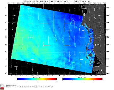
Wind maps retrieved from Synthetic Aperture Radar are availabe for users to browse and download in near-real-time (i.e. within 24 hours of the satellite data acquisition). The maps are snapshots of the wind speed 10 m above the sea surface. They reveal the offshore wind variability in great detail and show effects of the land, offshore wind farms, and other structures on the wind flow. Wind resource maps calculated annually from DTU’s entire archive of satellite based wind maps are also available to the users.


Content Block
nameCustomer experience
id2047532056

Users from the wind energy industry see a value in the satellite based wind maps since wind observations over the ocean are costly and sparse. Satellite based maps represent a useful supplement to model simulations and in situ observations of the wind speed.


Content Block
nameNeed
id2047532058
  • The offshore wind energy sector is expanding rapidly and there is a need for spatial wind data over the global ocean.
  • Spatial coverage beyond the European seas is essential and temporal coverage on the order of the years is needed.


Content Block
nameChallenges
id2047532059
  • Users from the wind energy industry inquire about the trustworthiness of EO-based wind data.
  • Users from the wind energy industry are not so fmailiar with EO data sets and require that data is easy accesses and use and that any uncertainties related to the data layers are well documented.


Content Block
nameResults
id2047532060
  • Users can browse DTU's archive with 300,000+ wind maps over the Europea seas and other selected areas with importance for offshore wind energy planning.

  • Users can download wind fields over an area of interest (e.g a future offshore wind farm site) and investigate the wind flow in detail. 
  • Users can view and download different wind atlases based on EO data or model simulations and use there for their own analyses and presentations.

Wind map retrieved over the German Bight on June 6, 2019. Winds are from the southeast and lee effects of several offshore wind farms in the area can be seen.


Content Block
nameReferences
id2047532061

Learn more about the service: https://science.globalwindatlas.info/ (select ‘European offshore wind atlas’ or ‘Offshore winds fields in near-real-time’ to see the EO based data sets)

Learn more about e-shape: www.e-shape.eu

A question? Contact the Helpdesk: https://helpdesk.e-shape.eu