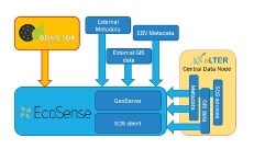
DEIMS-SDR is a established registry to document and access information on long-term observation facilities and the resulting datasets. DEIMS-SDR allows to manage and update this information once new data are created and data streams are made available. Via the web-interface information can be discovered using pre-defined filters, search by keywords or using the map search. This information together with EO data products developed by the mySpace pilot are visualised and made available through the EcoSense platform, which is the second service provided and is a one-stop window for users to access information. In addition, a REST-API for DEIMS-SDR as well as targeted applications, like crocotile to link in-situ sites to Sentinel tiles have been developed. By including accurate and up-to-date information in DEIMS-SDR, site coordinators benefit from a greater visibility of their site, platform and data, which can help to attract funding to support site investments.
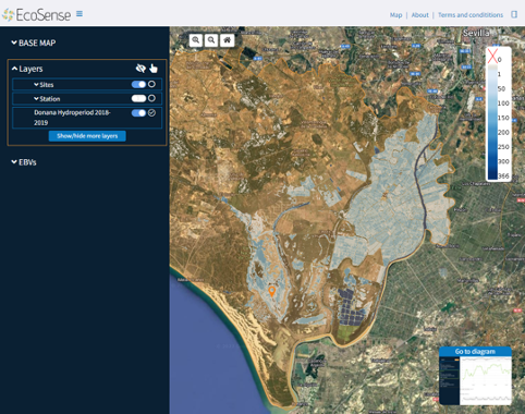 Image Added Image Added
 Image Added Image Added
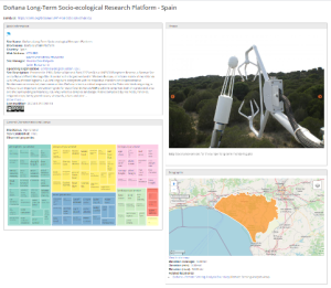 Image Added Image Added
 Image Added Image Added
The benefits of the Agrowth platform are the following: - It estimates the current phenology stage of crop and the fuzzy transition of them in the course of time. → Producer/Farmer knows every time in what stage his/her crop is and he/she is able to take action.
- It provides a heatmap for the sowing period of cotton which estimates daily the risk(high/medium/low) → Producer/Farmer has an indication about the right time of sowing, he/she is able to catch the possible sweet early window of April for cotton sowing.
- It predicts the yield in kg/ha, weeks earlier from the harvest. → Producer/Farmer has a good estimation of yield weeks earlier.
- It provides charts for the evolution of the vegetation indices NDVI, NDWI, PSRI and some crop specific indices. → Producer/Farmer has a good indication in order to monitor the vegetation health and the moisture of the crop.
- It visualizes the max and min ambient temperatures per parcel and it interplays with risk.resagri.eu. → Producer/Farmer has access to ResAgri’s detailed weather information in a 2km x 2km spatial resolution.
 Image Removed Image Removed  Image Removed Image Removed
|