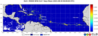
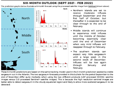
CERMES is relying on CLS high resolution (300m) weekly product of sargassum detection from multiple satellites sensors to produce a 6-month outlook bulletin on the upcoming sargassum season. This data helps CERMES to warn on the impacts on the tourism and fisheries industries in the Caribbean. “CLS has graciously allowed us access to their 7 day composite data files of high resolution satellite coverage for the entire subtropical region of interest. Forward tracking using a drifter based climatological ocean model from sargassum identified in the CLS composite shows the present situation in the tropical Atlantic and the expected situation until 6 months in advance. Once again, thank you for allowing access to your great data” Donald Johnson, USM, on behalf of CERMES |