
...
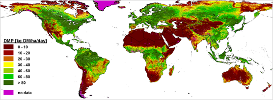
Vegetation Dry Matter Productivity (DMP) expressed in kg DM/ha/day (Source: VITO) | ||||||||||
Category | ||||||||||
PRODUCT DESCRIPTION | ||||||||||
Monitoring biomass with Earth observation data is done with two different approaches: estimating the amount of actual standing biomass or providing indicators on biomass production. In this product sheet we focus on the second as it is the most matured, operationally available and most relevant for agro-insurance applications. Biomass production is defined here as the increase in biomass, dry matter or carbon over time over a certain area. It is typically expressed as gram carbon per square meter per day (g C/m2/day) or kilogram dry matter per hectare per day (kg DM/ha/day) for agronomic purposes. When aggregated over time, these products give an indication of the seasonal increase in biomass, which could be related to pasture availability, crop yields or increase in timber in forestry. | ||||||||||
PRODUCT SPECIFICATIONS | ||||||||||
Main processing stepsThe products derived from satellites are generated by modelling primary production of plants by combining vegetation indices with meteorological information such as incoming radiation, temperature. Operational examples are the MODIS Gross Primary Production (GPP)/Net Primary Production (NPP) product and the Copernicus Global Land Service Dry Matter Production (DMP), focused on agriculture monitoring. These operational products are based on medium resolution satellite imagery and provide >10 years of information at 250m-1km resolution. Using Sentinel-2, biomass production indicators could be derived at 10m resolution at +- 5-10 days timestep. | ||||||||||
Input data sourcesOptical: Operational services available on Proba-V, Sentinel-3 and MODIS. Case studies on Sentinel-2 Radar: n.a.Supporting data: meteorological data (temperature, incoming radiation, vapor pressure) | ||||||||||
Spatial resolution and coverageSpatial resolution: 300m – 1 km Coverage: global Availability: Global medium resolution products at weekly to 10-day timestep are operationally available | ||||||||||
Accuracy / constraintsThematic accuracy: indication for biomass production Spatial accuracy: depends on input optical data and meteorological data grid resolution | ||||||||||
LimitationsGross Primary Production (GPP) data is often well calibrated and validated with in-situ measurements. GPP however only represents the potential biomass uptake and is not directly related to the availability of natural resources. Net Primary Production (NPP) or Aboveground biomass production (ABP) can be related more directly with crop yields, accumulation in forest biomass or pasture availability. Limited in-situ data is however available to develop these products hence a quality assessment is advised for the use of these products at local scale. | ||||||||||
Frequency / timelinessFrequency: 10 days Timeliness: <3 days after retrieval | ||||||||||
Delivery / output formatData type: Integer File format: NetCDF | ||||||||||
AccessibilityOperational products over Europe are available at medium resolution grids (250m – 1km). Copernicus Global Land Service Dry Matter Production (DMP) & MODIS Gross Primary Production (GPP)/Net Primary Production (NPP) Dedicated products on high resolution (e.g. Sentinel-2) could be developed by service providers. | ||||||||||
CHALLENGES ADDRESSED - USE CASE(S) | ||||||||||
Product Development:
Underwriting: Loss Adjustment: | ||||||||||
...