

DiveBase Malta is a dive centre based on the island of Malta, well known for its many excellent dive sites.
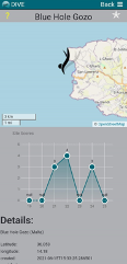
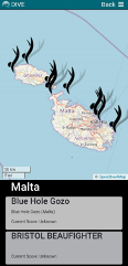
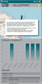
DIVE uses optical remote sensing by satellite to produce simple visibility scores for selected dive sites. The scores are published using a simple to use mobile phone app and enable recreational divers to quickly assess the expected visibility of a prospective dive site.
“We really appreciate your work and we are happy you were able to include the famous and most popular dive spots in Malta, Comino and Gozo.
"We downloaded the App on our Mobiles, a very easy and direct process; it's easy to browse and select the interested site from the list provided.”
DiveBase Malta.
EU science programs such as Copernicus are producing a Huge amount of data relating to the quality of sea water. These data are an invaluable resource for scientists but are not easy to use or understand for the non-scientific users such as recreational divers.
EO data must be discovered, curated and prepared for simple access before it can easily be used by non-specialist users.
Learn more about the service: https://dive.eofrom.space/
Learn more about e-shape: www.e-shape.eu
A question? Contact the Helpdesk: https://helpdesk.e-shape.eu
This page has no comments.