Global Urban Footprint
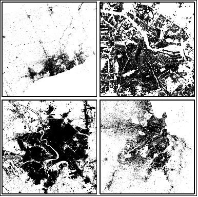
The Global Urban Footprint (GUF) is a dataset produced by DFD-DLR (German Remote Sensing Data Center of the German Aerospace Center). The fully-automated processing
system detects and extracts built-up areas from very high resolution radar satellite imagery. The result is a global binary settlement mask that outlines urban and non-urban areas at the unprecedented spatial resolution of approximately 12 m. A public domain version of it will be made available at the resolution of 50–75 m. With its global coverage and the enormous spatial detail, this initiative represents a promising contribution to global analyses of urban and peri-urban areas.
Details of the DLR Global Urban Footprint product for: Accra (Ghana), Amsterdam (Netherlands), Baghdad (Iraq) and Dar es Salaam (Tanzania). Credits: M. Marconcini (DFD-DLR).
References:
ESA 2013, Earth Observation for Green Growth: An overview of European and Canadian Industrial Capability
|
| urban energy efficiency (measurements of energy usage and loss in particular urban situations)
|
|
|
land use |
| ports and harbour management |
|
|
This page has no comments.