Weather | ||||||||
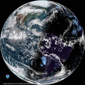
Image taken from GOES weather satellite | ||||||||
PRODUCT DESCRIPTION | ||||||||
Category | ||||||||
|
| |||||||
Uses | ||||||||
| ||||||||
Challenges addressed | ||||||||
| ||||||||
Geo-information needs | ||||||||
| ||||||||
Description | ||||||||
Weather satellites are available in geostationary orbit (focusing on one geographical region), in Low Earth Observation orbit (LEO, sun-synchronous), and High Earth Observation orbit (HEO, sun-synchronous can be used for frequent Earth observation of high latitudes or for the purpose of space weather). The geostationary satellites are further away from the earth’s surface and have thus a lower spatial resolution, whereas the non-geostationary satellites are closer to the earth’s surface with its higher spatial resolution. However, the geostationary satellites can monitor more frequent throughout time. Currently, geo-stationary satellites provide continuous view of about 1/3 of the Earth’s surface. Full coverage of all longitudes, excluding polar regions, requires six fairly-spaced satellites, nominally stationary over 0°, 60°E, 120°E, 180°, 120°W and 60°W. The weather satellites don’t give only insight in cloud-cover but also can provide information about: humidity, smoke, precipitation, aerosols, sea ice, snow cover, winds, lightning and sea surface/atmospheric/surface temperature. Depending on the spectral channel different parameters can be detected at different spatial resolutions. Precipitation is also observed with Precipitation radar satellites. Besides these sensor types also microwave (sun-synchronous, 3 orbits), multi-purpose meteorological (multispectral, visible and infrared, sun-synchronous and geo-stationary) imagers are frequently used for weather assessment: sea surface temperature, aerosols, land surface temperature, cloud properties and wind tracks. The weather satellites observe and monitor, where the results are used for research, modelling and prediction. Based on the observed meteorological parameters climate services (short-term, medium-term and long-term forecasting) are being developed. Weather observations and forecasts can be expected to be available in several formats: continuous (in case of geo-stationary satellites), 3-hourly, daily. | ||||||||
Known restrictions / limitations | ||||||||
| Weather satellites are used in weather models to forecast weather. The forecasting can take some time and because it is modelled uncertainty in quantity/quality occur. | ||||||||
Lifecycle stage and demand | ||||||||
Exploration | Environmental Assessment and Permitting | Design, Construction and Operations | Mine Closure and Aftercare | |||||
| ■■■ | ■ | ■■■■ | ■■■ | |||||
General: Weather is important to mining industries in all stages of the mining life cycle, because it can provide insight in safe access and emergency access. Exploration: sites are often in remote parts of the world and may need to be accessed by foot on ephemeral tracks or indeed by helicopter. Understanding the weather is critical to allow safe access to exploration sites. Design, Construction & Operations: Weather is important to mining industries as severe weather can interrupt production and operators may need to implement emergency plans for certain weather events such as rainstorms / hurricanes / extreme cold. Closure and Aftercare: Weather continues to be an important factor post closure. The most important individual parameter will be precipitation as it will directly influence the water balance in the site. Closure plans should be designed and implemented to cater for storm events (most jurisdictions will require one analyse weather post closure is less important than it would have been when the site was in operation, as the site should be capable of dealing with all-weather scenarios without the need for additional preparations. Weather data is also important in a post closure scenario to assess revegetation factors, particularly in more arid environments. In a post closure scenario the main area of interest will be relating to the TSF and WRD's and any other remaining infrastructure as such the area of interest will be in the order of 1km2 to 10km2. There are too many individual weather parameters to detail. Post closure precipitation is the key parameter - mm/day is the desired resolution. In a post closure scenario, access to daily weather data is sufficient. | ||||||||
Geographic coverage | ||||||||
| Depending on the satellite, regional or global. Global coverage is available | ||||||||
EARSC Thematic Domain | ||||||||
Domain | Atmosphere and Climate | |||||||
| Sub-domain | Meteorology | |||||||
| Product description | Forecast weather | |||||||
PRODUCT SPECIFICATIONS | ||||||||
Input data sources | ||||||||
There are many weather satellites which are bundled in the World Meteorological Organisations (WMO) global network of Meteorological Satellites (WIGOS). The geostationary satellites focus on one specific geographical region, whereas the sun-synchronous are polar-orbiting and cover (almost) the globe. Operational within WIGOS Geostationary
Sun-synchronous
Other
Planned:
Below will follow a few of the commonly used satellites: | ||||||||
| Satellite | GOES | FENGYUN | METEOSAT | Metop | NOAA-POES | Himawari-8 | ||
| Status | In operation | In operation | In operation | In operation | In operation | In operation | ||
| Operator | NOAA/NASA | CMA/NRSCC | EUMETSAT/ESA | EUMETSAT/ESA | NOAA | JMA | ||
| Data availability | Public | Public | Public | Public | Public | Public | ||
| Resolution (m) | 1km, 2km | 250 m – 1.25 km | 3 km | 1 km | 1 km | 1-2 km | ||
| Coverage | 137.2 W, 128 W, 105 W, 75.2 W, | 79 E, 99.5 E, 105 E, 112 E, Global | 0 E, 3.5 E, 9.5 E, 41.5 E | Global | Global | 140.7 E | ||
| Frequency (days) | 10, 30, 40 minutes | 15 minutes | 3 times per day | 3 times per day | 3 times per day | 10 minutes | ||
| Launch year | 2010-2018 | 2012-2018 | 2005-2016 | 2006 / 2012 / 2018 | 1998/2005/2009 | 2014 | ||
Website | link | link | link | link | link | link | ||
Minimum Mapping Unit (MMU) | ||||||||
n/a (the product is directly based on the input data; the smallest unit is 1 pixel, see above for spatial resolution of pixel size) | ||||||||
Accuracy / constraints | ||||||||
Thematic accuracy: Atmosphere and Climate – Meteorology 80-90%. Spatial accuracy: The satellites connected to the WIGOS network will be reviewed for their consistency, specified spatial and temporal resolution and timeliness. Different weather products (E.g. clouds, precipitation, temperature have different spatial accuracies). | ||||||||
Accuracy assessment approach & quality control measures | ||||||||
The satellites connected to the WIGOS network will be reviewed for their consistency, specified spatial and temporal resolution and timeliness. Different weather products (E.g. clouds, precipitation, temperature have different spatial accuracies). | ||||||||
Timeliness | ||||||||
Usually near real-time available. The weather forecast uses the weather satellites for their model forecasts and are usually also near real-time available. | ||||||||
Availability | ||||||||
Data is typically freely available through the open data policy of the different space agencies. See for an overview of the frequently used satellites the table above. | ||||||||
Delivery / output format | ||||||||
Typically the datasets are delivered in NetCDF format. The processed data in weather forecasts are also typically available in NetCDF and in web interfaces. | ||||||||
USE CASE | ||||||||
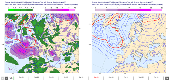
Source: ECMWF Weather satellites are used for medium term forecasting. For example using the ECMWF ensemble model, which provides forecasts of mean se level pressure (MSLP) over Europe in high resolution. | ||||||||
This page has no comments.