Air quality Particulate matter | ||||||||
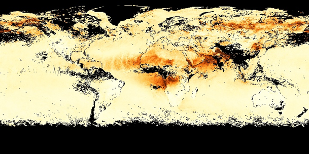
Aerosol Optical Depth observed by MODIS July 2019 (Source: NASA earth observations) | ||||||||
PRODUCT DESCRIPTION | ||||||||
Category | ||||||||
|
| |||||||
Uses | ||||||||
| ||||||||
Challenges addressed | ||||||||
| ||||||||
Geo-information needs | ||||||||
| ||||||||
Description | ||||||||
This product estimates the Particulate Matter (PM) concentration at ground in μg/m3. Particulate matter (PM or aerosols) is an important component of air pollution. Particulate matter assessment is of major concern around the world and many environmental protection agencies are working towards continuous monitoring and assessment of air pollution from surface based stations. The increase in the capabilities of Earth observation satellites in remote sensing retrieval of gas phase pollutants can, in fact, provide very useful information for improving estimates of spatial distribution and transport of PM. This is because aerosols interfere with the measurement of gas phase pollutants and all missions designed to retrieve gas phase concentrations must also estimate the aerosol contribution to the observation. In so doing, the aerosol concentration is determined. Satellite data can be used to map over large areas aerosol optical thickness (AOT) and Aerosol Optical Depth (AOD) which represents integrated atmospheric columnar loading of aerosols, especially when surface measurements are not available. Satellite based studies indicate that AOT and AOD data can be used to monitor PM2.5 pollution over global areas on a near daily basis. Many satellite missions have been launched to measure aerosols. Clouds and the interactions among these. Such missions as CALIPSO, and the MODIS series have given extensive information about both size and vertical distributions of aerosols. The recently launched Sentinel-5p/TROPOMI satellite also observes particulate matter. Often the satellite products are combined with backward trajectory models to investigate the sources of the observed dust and particulate matter. The satellite observations are delivered gridded and often used in forecast models (f.e. CAMS), but can also be used for observation purposes. | ||||||||
Known restrictions / limitations | ||||||||
| Satellite assessments of particulate matter (PM) air quality that use solar reflectance methods (optical sensors) are dependent on availability of clear sky; This means that mass concentrations of PM less than 2.5 microm in aerodynamic diameter (PM2.5) cannot be estimated from satellite observations under cloudy conditions or bright surfaces such as snow/ice. LiDAR and radar sensors (e.g. CALIPSO, CLOUDSAT), however, are very effective for these cases. | ||||||||
Lifecycle stage and demand | ||||||||
Exploration | Environmental Assessment and Permitting | Design, Construction and Operations | Mine Closure and Aftercare | |||||
| ■ | ■■■■ | ■■ | ■■ | |||||
Environmental Assessment & Permitting: Mining companies need to understand what impact they may have on the air quality around the operation and what impact this air quality might have on people and the environment. As part of the permitting process it is necessary to establish what the baseline is, and to demonstrate that this will not be materially affected when mining operations are underway and when the mine is closed and rehabilitated. Sampling will be required over a wide area and will typically be governed by dispersion modelling. A 10 km2 area may be taken as typical for monitoring of ambient air for a mid-size mining operation. Within this 10 km2 area in the order of 10 to 20 sampling points may be established. There are sulphur (COx, NOx and SOx). Individual metal parameters within the air column can also be determined. The amount of particulate that falls out on to the ground can be measured on a per m2 basis (typically 'X' mg/ m2/day). Minimum levels of detection can be taken from 'Technische Anleitung zur Reinhaltung der Luft', which is a comprehensive document issued by the German government, which describes air quality standards. This document, commonly referred to as the 'TA Luft', is used by many countries and organisations as a reference for air quality. Design, Construction &Operations: Mining operations will have point source air emissions from ventilations shafts, processing plants, labs, power plants etc. Measuring the quantity of different parameters emitted into the atmosphere (gaseous and solid) is an important aspect for mining companies to manage their potential environmental impact. Typical parameters are COx, NOx, SOx, Particulate, H2S. The area required to be assessed will be dependent on the footprint of the mining operation and could be 1 km2 to 10 km2. Air emissions can result in transboundary impacts on air quality beyond the site boundary. The extent of transboundary impact depends on the nature of the emission and also prevailing weather conditions and geographic features. Given the mobility of air emissions, an area of hundreds of km2 may need to be monitored. Air emissions will take place on a continuous basis. Many air emissions will be stable and infrequent measurement of monthly to quarterly will be sufficient. Other emissions will be more variable and subject to disruption, these would ideally be measured on a continuous basis. In addition to point source air emissions, mines will have significant fugitive air emissions, these can be plumes from pit blasts, dust form vehicular movement, dust blow off TSF / WRD, and fires. Monitoring for fugitive emissions is an important aspect for mining companies to manage their potential environmental impact. This fugitive monitoring can also be used to identify sources of emission and implement corrective actions (including identifying spontaneous combustion fires and arrange to have these extinguished). The frequency required for monitoring this parameter is site specific. In many instances monthly would be sufficient but in particular for the identification of spontaneous combustion continuous monitoring would be of benefit. Mine Closure & Aftercare: Monitoring will be required during the closure and aftercare period to demonstrate that there are no ongoing air emissions from the site that could cause an impact. Point sources will no longer be operational. The focus will be on fugitive emissions from WRD's and TSF's. Assessment of this parameter will involve field work including measurement of air quality for various parameters and measurement of particulate fallout. Depending on climatic conditions air emissions can travel long distances. The area to be assessed can be hundreds of km2. Monthly data is sufficient, this can be used to calculate daily deposition rates | ||||||||
Geographic coverage | ||||||||
| Coverage is global | ||||||||
EARSC Thematic Domain | ||||||||
Domain | Atmosphere and Climate | |||||||
| Sub-domain | Atmosphere | |||||||
| Product description | Monitor Air Quality and Emissions | |||||||
PRODUCT SPECIFICATIONS | ||||||||
Input data sources | ||||||||
| Satellite | MODIS AOD | TROPOMI/Sentinel-5p | CALIPSO | Sentinel- 5 | ||||
| Status | Operational | Operational | Operational (at lower orbit) | Future | ||||
| Operator | NASA | ESA | NASA | ESA | ||||
| Data availability | Public | Public | Public | n/a | ||||
| Resolution (m) | 3 and 10 km | 7x7 km | Depending on product | n/a | ||||
| Coverage | Global | Global | Global | Global | ||||
| Frequency (days) | daily | daily | 0.05 s for level 1b | Sub-daily | ||||
| Launch year | 1999 | 2017 | 2006 | 2020 | ||||
Website | link | link | link | link | ||||
Minimum Mapping Unit (MMU) | ||||||||
n/a (the product is directly based on the input data; the smallest unit is 1 pixel). | ||||||||
Accuracy / constraints | ||||||||
Thematic accuracy: Atmosphere– Monitor Air Quality and Emissions. 80% For the mining industry the targeted nano-satellites probably are the most suitable source of information, because emissions from water plumes can be very low. Probably the emissions caused by mining activities won’t cross the threshold in background values of the larger satellites. Spatial accuracy: See above. Needed accuracy in the mining sector is often for large areas in relatively high spatial resolution. | ||||||||
Accuracy assessment approach & quality control measures | ||||||||
This is done by field validation using in-situ measurements. | ||||||||
Timeliness | ||||||||
Usually within hours. | ||||||||
Availability | ||||||||
| Data is typically freely available for non-commercial use through the open data policy of the different space agencies. See for an overview of the used satellites the table above. | ||||||||
Delivery / output format | ||||||||
Typically, the datasets are delivered in HDF5, NetCDF, binary or in shapefiles. | ||||||||
USE CASE | ||||||||
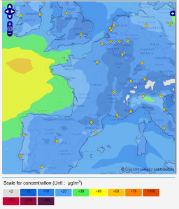
Source: PM10 daily mean forecast based on the Copernicus Atmospheric Monitoring Service (CAMS, Copernicus) The atmospheric observations are used in monitoring services of air quality for different air quality parameters. For example using the Coperniucs Atmospheric Monitoring Service (CAMS) provided by Copernicus to get hourly forecasts of Air Quality over Europe. Ensemble model (so called CAMS regional Ensemble) is based on seven state-of-the-art numerical air quality models developed in Europe from all seven models. They are combined via an ensemble approach, consisting in calculating the median value of the individual outputs | ||||||||
This page has no comments.