EO Products / Iceberg and bergy bit information
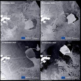
The Copernicus Sentinel-1 mission shared satellite images taken on October 19 and 31, and November 12 and 24, showing the trajectory of iceberg A23a. (Image credit: European Union, Copernicus Sentinel-1 imagery — Processed by @CopernicusEU).
Source: Satellites watch world's largest iceberg break away from Antarctica (photos) | Space
Product Description
An iceberg is a large piece of freshwater ice that has broken off from a glacier or an ice shelf and is floating freely in open water. The visible portion of an iceberg is typically only a small fraction of its total size, with about 90% of its mass submerged underwater. Icebergs can vary in size. A bergy bit is a medium to large fragment of ice, growlers are smaller fragments of ice.
Icebergs can be detected using a variety of technology, including optical, SAR, thermal infrared imaging. A combination of information from different sensors and iceberg drift models can enhance the accuracy of iceberg detection. In the specific, DMI has implemented improvements to the near-real-time iceberg detection system to make it more accurate and reliable, addressing:
- ships being mistaken for icebergs:
DMI now combines real-time AIS ship tracking data with satellite radar imagery. By matching the ship positions with the satellite data, false iceberg targets, that are actually ships, are removed.
Sea-ice floes near the sea-ice edge being incorrectly identified as icebergs: a new filtering process has been introduced using Automated Sea Ice Products (ASIP). These products are derived from the same satellite radar scenes as the iceberg detection, ensuring accurate alignment in both time and space.
These improvements significantly enhance the accuracy of a iceberg detection system, reducing false detections and providing users with more reliable information about real icebergs, see ACCIBERG(n.d.).
Further, it has to be highlighted that the multi polarization approach – i.e. the usage of a time series of QUAD Pol SAR data – should support the detection and distinction of icebergs and ships.
Product Specifications
BUSINESS PROCESS | IN, SO |
DESCRIPTION | Icebergs are large masses of freshwater ice that have broken off from glaciers or ice shelves and are floating freely in open water. Icebergs can vary widely in size, shape, and height. |
EO INFORMATION OF INTEREST | Detection of icebergs |
MAIN PROCESS STEPS | The iceberg concentration is derived by applying a Constant False Alarm Rate (CFAR) algorithm on data from Synthetic Aperture Radar (SAR) satellite sensors. |
INPUT DATA SOURCE | SAR imagery (e.g. Sentinel-1, EW and IW mode and mosaic for the two modes) |
SPATIAL RESOLUTION AND COVERAGE | 10x10km Coverage of the model domain (an enclosed sea, a bay) |
ACCURACY / CONSTRAINS | Generic and automated product. Expertise is needed to be correctly used. |
LIMITATIONS | Limited availability of ground truth. The interpretation of data can indeed be challenging, especially when handled by personnel without extensive experience in the field. |
TEMPORAL RESOLUTION | Irregular, weekly |
FREQUENCY UPDATE | Irregular, daily at any new SAR overpass |
DELIVERY / OUTPUT FORMAT | NetCDF-3, NetCDF-4, and esri shapefiles. |
ACCESSIBILITY | Copernicus Maritime service and Artic hub |
This page has no comments.