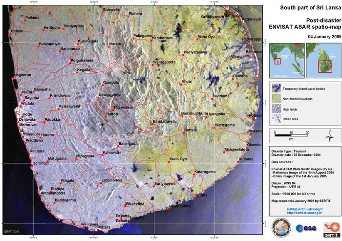
Disasters can be weather related, or they can result from geological events or antropogenic/technological causes. They require different types of interventions and skills for involved actors, but mapping disaster areas represents a constant component of all the steps of the disaster risk management cycle. It is useful both to guide rescue intervention and to support the recovery phase following a disaster. It involves the assessment of the most affected areas and provide key information for reconstruction. Moreover it support disaster resilience building because through the knowledge of past events' effect urban planner and institutions can take more informed decisions on future development. It can be defined in the different phases as rapid crisis mapping, situation mapping, and detailed damage mapping; reference mapping and asset mapping are used throughout the disaster management cycle. Earth Observation satellites provide scientific and operational data to the different actors involved: international institutions, governments and local authorities, researchers and citizens. Together with data acquisition, first processing and release, what is remarkable is the international effort needed to maintain archive data and keep record of disaster impacts, land use, infrastructure monitoring, to diminish future risks, have comparable records and learn from past intervention. |

Post-disaster Satellite Map Sri Lanka © ESA |
|
At the Understanding Risk forum in 2012 ESA presented the Earth observation's advantages over aerial data. Availability of worlwide imagery is not dependent on political reasons and it is feasible 24 hours per day, 7 days per week. Moreover coverage can be repeated several times to make comparisons, in some cases it is also possible to have several coverages per day, thanks to different satellites: this is clearly much more useful than a one-spot coverage with aerial data. Satellite data may be cheaper than singolar aerial campaigns, while timeliness is comparable. Resolution may still be lower with satellites, but technological advances already brought it to a range between 60 and 250cm. References http://www.understandrisk.org/sites/default/files/files/useruploads/10_bally_esa_final.pdf |