In the last few decades industrial fisheries has grown so much that excessive depletion of fish stocks is taking place world wide. Improved fisheries management has therefore become a necessity. As opposed to previous single-species focused conventional fisheries management, there is now an international consensus that an ecosystem-based approach should be followed. In this context satellite remote sensing proves to be of help in identifying potential fishing zones and to assess fish stocks. Global, daily, systematic, high-resolution images obtained from satellites are essential for the ecosystem approach to fisheries management (EAFM), because they assist in unravelling the complexity of changing abundancy and spatial distribution of exploited fish stocks. |

Bluefin tuna. Credit: NOAA |
|
The EAFM approach requires knowledge on aspects of the entire ecosystem including its geographic boundaries, the top-down pressure from predators or the bottom--up control from primary production, the natural variability of external forcing (including fluctuations in food supply and climate change), and biotic and abiotic ecosystem indicators. Conventional means of sampling and monitoring the ocean using oceanographic research vessels are very costly and limited in both time and space. Using these methods it is very difficult to study the entire ecosystem. Satellite remote sensing however makes it possible to sample the global ocean on synoptic scales at a relatively high temporal resolution. Both short- and long-term environmental variations can be detected with satellite-derived patterns of ocean temperature and primary productivity. Changes in environmental parameters may affect the recruitment, survival, condition, distribution patterns, and migration of fish stocks, either directly or indirectly. Key environmental parameters for assessing fish stocks that can be detected with satellite remote sensing include sea surface temperatures (SSTs), sea surface height anomalies and sea surface colour revealing the abundance of chlorophyll a. As phytoplankton concentration responds to short-term changes in the marine environment, detection of chlorophyll distribution by visible spectral radiometry, (also referred to as ocean colour monitoring) shows a map of connectivity of the marine ecosystem to the source of its sustenance. Because primary production is a first-order index of local carrying capacity; phytoplankton production is directly related to total fish landings. Harmful algal blooms, causing massive fish kills can also be detected with SRS. Composite images of phytoplankton biomass can be constructed using data from a number of global ocean-colour sensors such as SeaWiFS and MODIS. 
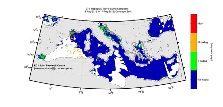
Potential habitat of the Atlantic bluefin tuna in near-real time (with a one month delay for preventing any use for fishing, 3-day composite). Credit: JRC |
Understanding the factors that influence survival of larvae of commercially important fish and shellfish stocks is particularly important. Adverse effects from fishing are hard to distinguish from environmentally driven declines in larvae concentrations. Information on how the environment influences underlying stock recruitment relationships is essential for defining reference points and baselines in order to achieve sustainable fisheries. Satellite derived SST and chlorophyll data are also used to predict potential spawning habitat. |
|
Identifying spawning and/or feeding grounds with satellite remote sensing (SRS) contributes to spatially oriented management measures; satellite-derived chlorophyll and SST data can be used to map fish habitats. Satellite-derived habitat mapping can contribute to the sustainable management of for example the Atlantic bluefin tuna, the European hake and fin whale in the Mediterranean Sea and the yellowfin and skipjack tuna species in the tropical Atlantic and Indian Ocean. The mapping of feeding habitat of these species is part of a EC project called FishReg, for which they make use of the JRC habitat model which requires satellite data of Sea Surface Temperature (SST) and surface chlorophyll content (CHL) from Modis-Terra (SST), SeaWiFS (CHL) and from MODIS-Aqua sensor (NASA). For tuna also the spawning habitat is computed. It is evident that earth observation with satellite remote sensing facilitates and improves the implementation of an ecosystem-based approach to fisheries management. The application of satellite technology for fisheries management questions is being promoted internationally by the Group on Earth Observations (GEO). That group is leading the development of a Global Earth Observation System of Systems (GEOSS) to address a broad range of societal benefits, such as the improvement of fisheries management. In addition there are a number of organizations and projects involved such as NOAA, JRC, SAFARI (Societal Applications in Fisheries and Aquaculture using Remotely-sensed Imagery) programme, FISHREG and FISHSAT (Integrated Satellite Services for Fishing Support and Safety). |