| Content Layer |
|---|
|
| Content Column |
|---|
| tabbed-blocks | true |
|---|
| id | 353327289 |
|---|
| |
|
...
...
Description
This project is driven by the needs of the oil & gas industry with regards to offshore exploration and operations, Health and Safety, sustainable development and national and international regulations. The goal is to determine how Earth Observation products and services can best aid the industry at all phases of the OGP lifecycle. Our consortium will work in close collaboration with the oil & gas industry to identify challenges, provide an inventory and description of existing EO data solutions, analyze the gap between user requirements, available products and current uses, and define expectations in terms of improvement of EO data/services and development of new services.
Special attention will be paid to the typical phases of an OGP project: Pre-license acquisition, Exploration, Development, Exploitation/Production, and Decommissioning.
Our geographical areas of interest include:
- Angola,
- South Africa,
- Mozambique,
- Northern Brazil,
- Argentina,
- Caspian Sea.
| Team membersCLSCLS has over 25 years experience in delivering data and services to customers all over the world. With a staff of 470, in France and abroad, CLS offers services in environmental monitoring, maritime security, and management of marine resources to a broad range of professionals including government, industry and the scientific community, and maintains an operational center with expert support 24/7. Sine 2001, CLS has developed services for the oil & gas industry based on its built-in expertise on data collection, radar imagery or numerical modelling. MeteogroupMeteogroup, founded in 1986, is one of the largest European weather organizations (12 offices including Poland), serving the Oil & Gas industry with numerous products & services. Meteogroup is present on all continents addressing the Oil & Gas community (operators, engineering, and seismic) and thus has a perfect understanding of the EO weather data that are critical throughout an oil & gas project life-cycle. Nansen Environmental and Remote Sensing Center (NERSC)NERSC, founded in 1987, is a key Norwegian leader that provides oceanography EO and model products to Oil & Gas industry. Tullow OilTullow Oil kindly supports the team as a consultant. |
|
|
...
...
Meetings
| Advanced Tables - Table Plus |
|---|
| columnAttributes | style="width:180px;",style="width:120px;",style="width:120px;",style="width:120px;",style="width:120px;",style="width:300px;" |
|---|
|
Participants to discussions | Meeting | Date | Location | Agenda | Notes | Comments/Documents |
|---|
| Workshop | ko+10 months | | | | | | Review | ko+2 months | | | | | | Kick-off | 7th March 2014 | Frascati | | | |
|
...
| Funded by the European Space Agency, the aim of the EO4OG project is to determine the current and future needs of the Oil & Gas industry in terms of Earth Observation products and services. The project will unroll in three phases over a 10 month period. Our selected participants have received a PDF brochure (click here to download) explaining the EO4OG project goals and objectives and providing a brief overview of the survey questions. The survey itself will be carried out over the telephone, to best understand participants’ challenges and requirements. As the survey forms are completed, we will make the results available online, via the OGEO portal. This project is driven by the needs of the oil & gas industry with regards to offshore exploration and operations, Health and Safety, sustainable development and national and international regulations. The goal is to determine how Earth Observation products and services can best aid the industry at all phases of the OGP lifecycle. Our consortium will work in close collaboration with the oil & gas industry to identify challenges, provide an inventory and description of existing EO data solutions, analyze the gap between user requirements, available products and current uses, and define expectations in terms of improvement of EO data/services and development of new services. Special attention will be paid to the typical phases of an OGP project: Pre-license acquisition, Exploration, Development, Exploitation/Production, and Decommissioning. Our geographical areas of interest include: - Angola,
- South Africa,
- Mozambique,
- Northern Brazil,
- Argentina,
- Caspian Sea.
|
|
|
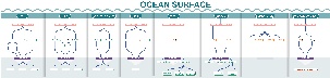
| The OTM assessment of information needs is organised into 6 areas; pre-license phase, exploration phase, development phase, production phase, decommissioning phase, and generic requirements. To access the list in each category, click on the links. The challenges have also been organised into "challenge trees". To access each challenge tree click on the box in the image below. To see the full challenge tree, open the pdf file. All challenges are available in a single numerical list on the CLS challenges page. Pre-license phase| Content by Label |
|---|
| showLabels | false |
|---|
| sort | title |
|---|
| showSpace | false |
|---|
| operator | AND |
|---|
| labels | CLS pre-license |
|---|
|
Exploration phase| Content by Label |
|---|
| showLabels | false |
|---|
| sort | title |
|---|
| showSpace | false |
|---|
| operator | AND |
|---|
| labels | cls exploration |
|---|
|
Development phase| Content by Label |
|---|
| showLabels | false |
|---|
| sort | title |
|---|
| showSpace | false |
|---|
| operator | AND |
|---|
| labels | cls development-phase |
|---|
|
Production phase| Content by Label |
|---|
| showLabels | false |
|---|
| sort | title |
|---|
| showSpace | false |
|---|
| operator | AND |
|---|
| labels | cls production-phase |
|---|
|
| Anchor |
|---|
| decommissioning |
|---|
| decommissioning |
|---|
|
Decommissioning phase| Content by Label |
|---|
| showLabels | false |
|---|
| sort | title |
|---|
| showSpace | false |
|---|
| operator | AND |
|---|
| labels | cls decommissioning |
|---|
|
Generic requirements| Content by Label |
|---|
| showLabels | false |
|---|
| sort | title |
|---|
| showSpace | false |
|---|
| operator | AND |
|---|
| labels | cls generic-requirements |
|---|
|
|
|
|
Challenges
...
| | Advanced Tables - Table Plus |
|---|
| columnAttributes | style="width:180px;",style="width:120px;",style="width:120px;",style="width:120px;",style="width:120px;",style="width:300px;" |
|---|
| Participants to discussions | Meeting | Date | Location | Agenda | Notes | Comments/Documents |
|---|
| Workshop | ko+10 months | | | | | | Review | ko+2 months | | | | | | Kick-off | 7th March 2014 | Frascati | | | |
|
|
|
|
...
...
| This is the area to show published documents for review or for use. Documents in preparation by the team should be kept on the project team page. | Advanced Tables - Table Plus |
|---|
| columnAttributes | style="width:180px;",style="width:120px;",style="width:120px;",style="width:300px;" |
|---|
| |
|
|
|
...
...
Project Team Area
Funded by the European Space Agency, the aim of the EO4OG project is to determine the current and future needs of the Oil & Gas industry in terms of Earth Observation products and services. The project will unroll in three phases over a 10 month period.
CLS has selected a panel of offshore OGP actors from all phases of the lifecycle to participate in Phase 1 of the project, a survey that will help determine the geo‐information requirements of the offshore industry. As defined by the project requirements, survey participants work in one of the following geographical zones:
...
...
Our selected participants have received a PDF brochure (click here to download) explaining the EO4OG project goals and objectives and providing a brief overview of the survey questions. The survey itself will be carried out over the telephone, to best understand participants’ challenges and requirements.
...