Page tree

Versions Compared

Key

  • This line was added.
  • This line was removed.
  • Formatting was changed.

...

Content Layer
id353386303


Content Column
tabbed-blockstrue
width100.0%
id2047532052


Content Block
nameSummary
id2119714053

Valorising long-term ecosystem research sites and associated in-situ data


SponsorProject Solution providerUser


Protected Area Managers, Scientists, Environmental Assessment Agencies, restoration EU policy


Content Block
nameTaxonomy
id2119719941
  • Environmental, biodiversity, pollution
  • Meteo & climate
  • Education, training & research
  • ICT, digital interfaces
  • Local & regional planning


Content Block
nameUser profile
id2047532054

Main users of the services provided by the mySite pilot are researchers, site and protected area managers as well as the wider public. The main user is characterised by the need to access information on long-term observations collected on dedicated areas. These are either long-term observation facilities or protected areas. This is reflected either by the research community applying scientific analysis for the given areas or protected area managers informing about the status of areas of interest in order to perform daily management.


Content Block
nameService description
id2047532055

DEIMS-SDR is a web-catalogue for long-term observation facilities and data and as service adopted by the eLTER network and operated and maintained by the Umweltbundesamt GmbH (Austria). EcoSense is webGIS to visualise spatial and time-series information and as service adopted by the eLTER network and operated and maintained by the BioSense Institute (Serbia)


Content Block
nameCustomer experience
id2047532056


DEIMS-SDR and EcoSense provide services for users to document and visualise information on long-term observation facilities as well as data gathered at these locations. EcoSense provides a on-stop interface to access this information and to visualise collected information.User stated "it is a very important new step for DEIMS-SDR and for eLTER!!! Congratulation."


Content Block
nameNeed
id2047532058

When dealing with Earth Observation data pipelines as well as scientific analysis the use of in-situ data as well as understanding the context of observation is an important issue. This applies e.g. for the integration and use of in-situ datasets to produce meaningful value added EO data products. Providing services to register and document long-term observation facilities as well as the data collected and providing means to visualise and access them in an easy manner was one of the main aims of the mySite pilot. This should allow for the integration of in-situ data as well as EO data products generated for a given area. This not only supports scientific workflows but also supports the management of selected areas, e.g. protected areas, to support daily management.


Content Block
nameChallenges
id2047532059


Information on long-term in-situ data is provided via multiple platforms ranging from local offline data descriptions to national network scale metadatabases. Thus, in-situ datasets are not ubiquitously available but must be made findable and accessible, yet conserving associated data rights and licenses. In addition, information on the observation context needs to be provided in order to plan and conduct scientific analysis or plan targeted observation. This also includes to provide sufficient and comprehensive information on relevant long term data sources and observation sites across different domains and biogeographic gradients as well as to provide access to easily retrievable, localised (=site-based), and standardised validated biodiversity and ecosystem data. In order to address these challenges, DEIMS-SDR has been developed to document long-term observation facilities and datasets as well as EcoSense as a visualisation and access interface to support the user needs.


Content Block
nameResults
id2047532060

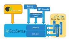
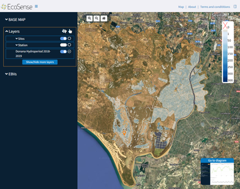
DEIMS-SDR is a established registry to document and access information on long-term observation facilities and the resulting datasets. DEIMS-SDR allows to manage and update this information once new data are created and data streams are made available. Via the web-interface information can be discovered using pre-defined filters, search by keywords or using the map search. This information together with EO data products developed by the mySpace pilot are visualised and made available through the EcoSense platform, which is the second service provided and is a one-stop window for users to access information. In addition, a REST-API for DEIMS-SDR as well as targeted applications, like crocotile to link in-situ sites to Sentinel tiles have been developed. By including accurate and up-to-date information in DEIMS-SDR, site coordinators benefit from a greater visibility of their site, platform and data, which can help to attract funding to support site investments. 


Content Block
nameReferences
id2047532061

Learn more about the service:https://deims.orghttps://ecosense.biosense.rs; https://elter-crocotile.datalabs.ceh.ac.uk/https://www.youtube.com/watch?v=w8IizVvSYVs

Learn more about e-shape: www.e-shape.eu

A question? Contact the Helpdesk: https://helpdesk.e-shape.eu


...