Celebrating our first anniversary we returned to the evidently popular subject of the use of AI technology for Earth Observations. In a previous EOcafe on the 4th February, we heard from the AI4EO project which is one of many springing up with different sponsors at European and national levels to promote this synergy between technologies. There are many initiatives[1] and one of our aims in EOcafe is to try to help clarify this somewhat complicated landscape.
Our focus this week was the initiative AI4Copernicus which is a newly launched project under Horizon 2020. The project manager, Vangelis Karkaletsis (Director at the Institute for Informatics and Telecommunications at Demokritos), explained the structure of the project, its partners and the links with some of the other initiatives especially the DIAS and a second H2020 project, AI4EU. AI4EU involves partners from research and industry aiming to deliver research and innovation in AI. It is a broad programme spanning many different sectors to which, AI4Copernicus seeks to add EO services. One key deliverable is the provision of a catalogue of AI resources and tools, an experimentation platform, a content manager system for AI events and open calls. AI4Copernicus partners include companies involved in 3 of the DIAS platforms, public institutions and research institutions to enable AI and EO innovation.
A key goal of the project is to provide a bridge between Copernicus as an EU flagship and its data and services available through the 3 DIAS and the resources available under the AI4EU. As expressed by Vangelis, to make the AI4EU AI-on-demand platform, the platform of choice for users of Copernicus data along the value chain (scientists, SMEs, non-tech sector). The Dias’ Creodias, Mundi and Wekeo are all represented amongst the project partners. AI4Copernicus will provide support to teams creating new services which will be installed on at least one of the 3 DIAS.
Xenia Ziouvelou, (Research Associate at NCSR Demokritos & Lead of the AI4Copernicus Open Calls) explained how the project will launch calls for new services integrating EO data, and AI technologies. An important contribution of this project, as Xenia mentioned, is the possible creation of new ecosystems as a result of by bringing together these communities, including technology advancements, new markets, at innovation and industry levels.
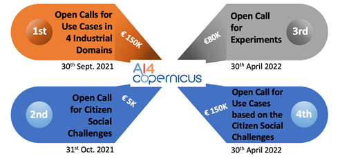
Xenia explained that there will be 4 rounds of calls, the 1st call will be for use cases in four industrial domains in the areas of energy, health, security, and agriculture domains. The 2nd call is to be focused on citizen social challenges, the 3rd call for experiments and the last call on use cases based on the citizen social challenges. AI4EU will provide cloud infrastructure for the successful applicants and also create instances inside the DIAS platforms to enable the successful candidates with data sets access, cloud, and services among some tools. Regarding the financing, Xenia mentioned for the first round of calls it is provided a 100% funding for a two or more partner consortium of up to 150,000 EUR per project. Important to note that the consortium must have a partner with at least some expertise on AI to assure the running of the project.
Responding to a suggestion from Alberto MenVangelis agreed that this is a good example of a new tool that could be installed on a DIAS platform and made available through AI4EU (or vice versa). This could then be used by many new services as a building block. He mentioned as an example the existence to populate tools demand applied to this case could be the use of tools of the AIEnergy project, which is one of the ‘sister’ projects and how its datasets can be used as well for AI4Copernicus.
Geoff asked about the sustainability of the AI4EU platform as the project ends in less than 9 months time (end 2021)? How can challenge winners be confident that effort invested in installing their applications on either DIAS or AI4EU will still be supported in 1- or 2-years’ time? Vangelis explained that this is currently being studied but that the leader of AI4EU, Thales, is committed to keeping the platform running. The AI4Copernicus project will contribute to the sustainability by enriching the set of tools which are available. Research projects are expected to contribute more tools which will extend the AI4EU platform and ensure it is used by other communities. In terms of the funding to secure this, it is not yet clear, but it is foreseen to establish a foundation and more details on this will be worked out in the next few months.
Four partners in the project are potential users of new services. Richard Hall (Equinor - a leading energy company) outlined some of the questions which he would like to be addressed through challenges and that there are links between the 4 sectors to be addressed: For instance,
- Energy and health, how do the activities of energy companies’ impact on the health of a city?
- Energy and security, how much energy can Europe produce? Where is it needed or will be needed in 50 years time?
- How can EO and meteorological data be used to optimise the cleaning of solar panels from dust and particles gathering on them?
Vangelis confirmed that questions like these will be included in the calls as a guide to those responding.
Vasilis Baousis from ECMWF introduced his view of the project with both the use of data from CAMS and the use of the DIAS WEKEO where ECMWF is a partner with Eumetsat and Mercator. Vasilis also cited Destination Earth as another future resource and source of tools and data. Vangelis also pointed out the link with the AI4EO project through ECMWF which is driving their first challenge launched by this other project.
Michele Lazzarini from SatCen mentions that security is an important domain with possible applications connected to other sectors. For this, SatCen is currently drafting its calls based on security needs and the interaction with other sectors (e.g. climate).
Vangelis summarised with a reminder that funds are available! The first calls will be launched in June/July with a deadline to respond by end-September. The 6 selected projects, each for up to €150k, will be launched in January 2022. Good luck to everyone!
Geoff Sawyer & Sandra Cabrera Alvarado
[1] AI4EO (ESA), AI4EO (EC), AI4EO (DLR), AI4EU (EC), AI4Copernicus (EC), AI4Copernicus (Copernicus Relay in Wallonia and Luxemburg), AI4GEO (CNES) and many more.
How can we help the media get better use of EO in its progressive use? This was the main question raised by Geoff while opening this EO Cafe. Since the launch of Landsat (1972) followed by SPOT (1986), EO has been used as a tool by journalists to show the readers of the days’ newspapers i.e. the main-stream media (MSM), images of the Earth to illustrate their stories. Never seen before, these images were highly educative and certainly led to a much greater awareness of geography and local news amongst the wider population. However at the time, these tools were costly depending on the resolution and provider.
Today, on the other hand the offer has changed. Public and commercial EO satellites offer free access to images as a way to promote their capabilities, making satellite imagery accessible to journalists. For example, Twitter recently featured satellite images of the EverGiven container ship stuck in the Suez canal using several types of imagery and providers. EO imagery is now often used by journalists to provide depth to the story by illustrating it and enhancing interest worldwide whilst providing to readers new perspectives, illustrating events or showcasing remote areas.
Each of the main (optical) satellite operators has a media office that works closely with news outlets to on the one hand support the storytelling and on the other to promote their capabilities – as well as developing a philanthropic image. Hence the mix of promotional commercial imagery and free public data coming from ESA, NASA, ISRO and other agencies, supported in some cases by extensive analytic capacity is keeping news sources satisfied. Important to say also that today a lot of the focus has moved away from the MSM onto social media – even for the traditional publishers. The digital version has become the reference even if a paper version is still published. Added to this we have social media that also act as new online media channels like Twitter, Facebook, Instagram, etc.
According to Jonathan Tirone, News Editor from Bloomberg, who was a guest in our recent EOcafe, EO imagery is bringing a new language to the media as it becomes much more widely accepted in newsrooms. Jonathan gave a number of examples including that of the Gchine uranium mine in Iran. This had been the subject of some detailed analysis showing how Iran had reopened the mine contrary to international agreements and, more particularly, had built facilities to process the ore. He observed also that Google Earth had played a strong role in warming up the news editors due to its easy access offer to satellite imagery with enough resolution. This is the case of the Copernicus Climate Change Service, which Jonathan mentioned, which has revolutionized the open-source platforms on coverage of climate change in Europe due to its free access. Nowadays the access to data is not an issue as before but Jonathan stressed out expertise is needed for an accurate interpretation and give the image an accurate context while doing the storytelling.
It is precisely this need that Jonathan notes it has originated a need in remote sensing analysts describing it as a “discrete“ industry in the bloom that has awakened the investors‘ interest. Another trend he pointed out was the need for the use of new technologies, such as big data tools for reporting as well as AI analytics. Most likely the next generation journalists will know how to combine techniques of writing, video production and use of technology as tools to enrich the newsrooms.
In addition, the immediacy of news reporting today is fuelling demand for instant reactivity from image providers as Remco Timmermans (#timmermansr) mentioned, who was our other guest in this EOcafe, and who, in 2020 was designated the #EUInfluencer for space. Remco presented the use of EO in the media from another angle. The use of EO for examining the veracity of reporting events. He called this “investigative journalism“ where journalists take in situ images from social media and prove its veracity by comparing them with satellite images for this fact-checking. As an example, he talked about the case of the Syrian war reported by Bellingcat “spaceproofing” what occurs on the ground.
Remco illustrated this with the examples from the EverGiven and the succession of images from each operator appearing on Twitter. These gave a fantastic opportunity to compare the images and not just those from optical satellite! After Sentinel-2, which set the scene, we had images from Planet, from Maxar (GeoEye) and from Airbus (Pleiades) showing in increasing detail the stuck ship and the efforts to release it. Maxar had the chance to have a satellite within range at the time the ship was freed demonstrating the advantages in having constellations and multiple imaging opportunities.
Both Iceye and Capella space released radar (SAR) images of the ship taken at night to illustrate the advantage that radar offers. These also illustrated the different features which radar highlights and hence the need for expert interpretation. For example, the foreshortening effect caused by the different image properties needs to be well understood – but then can be very useful and provide completely different information.
Does the industry support the news in this reporting effort? Jonathan mentioned that EO sometimes is a fairly tight community with limited possibility to bring expertise to interpret data for news purposes. On the other hand, Remco proposes a solution to this need of technical skills by mentioning imagery platforms such as the Sentinel Hubs make available processed imagery that could facilitate its distribution. This raises the question if whether in the future, this should be part of journalistic training. However, indeed these portals are not necessarily intended for journalism purposes as pointed by Remco. On the other hand, the friendliness or usage of platforms still remains subjective and even debatable, what it is not is the possibility of journalists to seek EO specialists and more continuity in satellite imagery supply.
Remco also provided a list of some of the more important influencers on the subject of EO, several of whom were in the audience. Geoff Smith (#DrGeoffSmith) one of the influencers identified by Remco, asked if information products or an optical image was better? The answer was it depends on the scope of the work but most importantly on the targeted audience. Whereas a remote sensing specialist would like more detailed technical information for decision making, an optical image will be better for a general audience visiting social media. Remco mentions this as “humanizing data” to civil society, in general, is the best option to showcase the benefits and opportunities of EO.
Stephane Ourevitch (#ourevitch_stp), and who is very active on Twitter behind the DG-DEFIS (#defis_eu) account, considers that the tools are out there which journalists can use. With no background in remote sensing, Stephane finds the Sentinel Hub (#sentinel_hub) a relatively easy tool to use to gather images to support stories. This led to further discussion concerning the training of journalists or support from the EO services sector. Remco also identified Pierre Markuse (#Pierre_Markuse) author of a useful guide for journalists[1] and Ground Station Space (# Dot_Space) which he supports as good, reliable resources.
This information brought by journalists also faces the issue of “fake news”. Dietrich Hans who was part of the audience raised this pertinent topic by presenting the possibility of a satellite image being misused to create misinformation. Jonathan shed some light by commenting the more sensitive the story or topic is a higher level of analysis is needed. Indeed, depending on the topic, further investigation is needed and crucial, rather than just using satellite imagery as the main evidence, such as the case of the Iraq war in 2002 used as main proof by the US and remains debatable. However, this further investigation remains a pillar for journalists, where, in this case, satellite analysis must be supported by other sources to be used as a reliable source of information.
The intervention of our guests showed us the two sides of how EO can be used in the newsroom, either as an illustration and scene setter with the image attached to the story or in the form of investigative journalism. Whether a need to set up a mechanism to have access to a remote sensing specialist remains a question that possibly in the future needs to be addressed to assist the journalist sector in their uptake of EO to be used in an ethical and responsible way.
Sandra Cabrera Alvarado & Geoff Sawyer
For further reading:
Space race over the Suez Canal see groundstation.space
Pierre Markuse “Satellite Image Guide for Journalists and Media” provides an overview and some tips on how to use/create satellite images for media.
[1] Pierre Markuse “Satellite Image Guide for Journalists and Media” provides an overview and some tips on how to use/create satellite images for media.