Yesterday, we attended the press conference where the European Commission’s and the European Space Agency’s representatives proudly introduced the first images acquired by the radar instrument, providing the possibility of a day and night, all-weather, frequently revised world coverage. As a newcomer to the EO sector I found the imagery very impressive and the images shown gave just a glimpse of the 1.8 terabytes per day that will be collected by Sentinel 1. We recognise that it is a challenge for European institutions and industry to distribute and digest the huge amount of information they bring. Here’s the link for self-registration and download of Sentinel-1A available data provided: http://scihub.esa.int/.
Sentinel-1A, the first Copernicus’ environmental monitoring satellite, has been flying for just one month. It is still in the commissioning phase, but the expectation is so high that everybody is already working hard to show what the basic products coming from its data will look like.
The session was organised with 6 users showing radar applications in the domains of ice and ocean monitoring, maritime surveillance and environmental protection, emergency management and preparedness, climate change and innovative land cover analysis. Present stakeholders all praised especially the high coverage rate of this first EC – ESA radar satellite; which will be increased when Sentinel 1B will fly as well. Some also underlined how the objective of this mission is to provide a global continuous and consistent mapping of the whole planet: this is to complement other national, public or private missions with higher resolution and different characteristics.
The promise is to have a fully operational satellite after the summer 2014. First results open the way for a bright perspective that free and open data will deliver to value-adding companies and end users and some of the potential contribution to future scientific research. SMEs and start-ups, the engine of European growth, will be able to access and exploit this resource. EC and ESA are committed to keep on working for a smooth deployment of the rest of the Sentinel fleet and at EARSC we are also committed to continue to help the industry develop new business from this exciting new data source: the European Copernicus programme.
I participated yesterday to the Geospatial World Forum 2014 pre-conference session on "Geospatial Industry forging ties with GEOSS: A Value Proposition. It proved to be a useful forum with around 50 persons in attendance largely from the GEO community (secretariat and executive) and the EO services industry (data suppliers and value added). There was a good representation from around the world which led to an excellent discussion on the question of how GEO will engage with industry.
EARSC has been active for several years in saying that there needs to be a dialogue between GEO and industry - in fact we first wrote to GEO saying this in 2005 - so we welcome the fact that the GEO stakeholders have now agreed that the GEO secretariat should develop this engagement. It seems obvious that in a sector where there is such an overlap between the public and private sectors that an organisation with the global mandate to encourage a GEOSS through co-ordinated actions must take into account what the private sector can offer. We see this as a two-way process whereby GEOSS can benefit by including private offerings and the private EO service companies can benefit increased exposure of their products and services. But more importantly society can benefit through improved organisation of the supply of EO services leading to economic and societal benefits.
The audience were mostly in line with this proposition. A number of questions emerged such as the role of licences in distributing the data, how to engage with the large number of SME's (through an association like EARSC), how to resolve offers from the private sector and public sector organisations and most importantly what role exactly should GEO play in this; from discoverability of data through to directly offering data. My presentation talked more about the role which we believe that GEO can play.
Over the next few months we shall seek to deepen the understanding and to find some very specific actions from which to build a co-operation. Yesterday was a good start towards establishing a framework for this effort.
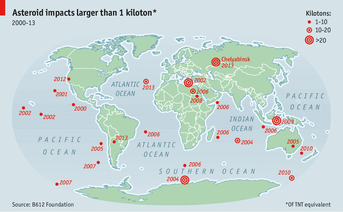
Whilst we are all aware of the risk of an asteroid strike on our planet, maybe we are not so aware of the number of strikes that already take place. The B612 Foundation has published a video and The Economist this week published a map showing asteroid strikes on The Earth over the last decade. Happily all of them resulted in aerial explosions but with surprising force. The data comes from the B612 foundation which is raising funds to launch a "Sentinel" IR satellite to detect small asteroids earlier and hopefully to guard against one of these explosions taking place over a city where the damage could be enormous.