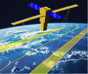
Wavemill is a new mission concept based on Synthetic Aperture Radar. The mission will provide measurements of ocean surface currents as well as wind vectors and swell. The goal is to measure to 0,05m/s accuracy at a resolution of 1km. The mission is currently being proposed as an ESA Earth Explorer candidate. An airborne campaign has shown the proof of concept. —
 - National Oceanography Centre, Southampton, UK -
 ![]()
The response of the ocean biosphere to climate change is one of the greatest uncertainties in climate predictions. There is growing evidence about the role of small scale oceanic features in vertical transports. Resolving the mesoscale is the prime motivation for a new Surface Water & Ocean Topography mission. Ocean surface current vectors and sea surface height are two of the most important ocean properties for oceanographers and operators in the maritime domain.
Oceans are dominated by ubiquitous oceanic features at the mesoscale (10-100 km) and sub-mesoscale (1-10 km). Monitoring data is available in the form of high-resolution IR (Infra-Red) SST (Sea-Surface Temperature) and ocean colour measurements, but little/no data is available from space on ocean dynamics at these scales. Nevertheless these data are relevant to upper ocean dynamics and atmosphere/ocean coupling, especially for horizontal and vertical mixing & transport, large scale ocean transport and ocean biology, and atmosphere/wave/ocean interactions.
There is a strong scientific requirement for new satellite observations of ocean dynamics at the mesoscale and sub-mesoscale:
- —There are no means at present to measure total currents from space on these small scales
- Recent research highlight the importance of ageostrophic currents and wind/eddy interactions
- Although Wavemill will be a science mission, accurate and timely knowledge of ocean surface currents will also be of great importance to maritime industry such as shipping, oil and gas exploration, search and rescue, oil spill response and the verification of ocean current models.
What's new in Wavemill?
—Wavemill is an innovative instrument promising to deliver high-resolution currents and winds, right up to the coast, including ageostrophic currents and coincident measurements of swell, all measured from space. The concept has a 2 x 100 km swath, 1km resolution and 0.05 m/s accuracy.
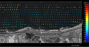
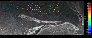
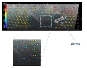
The Wavemill concept was successfully demonstrated in airborne flights over the Irish Sea.
The information provided by the Wavemill radar must contribute to the study of climate change and rising sea levels. Wavemill aims to provide better data to test upper ocean dynamics theories on global scale.
In addition, Wavemill will provide data of great importance to the maritime industries which can significantly help to mitigate against the impact of strong ocean currents. An up to date knowledge of ocean currents will provide enormous cost benefits to commercial shipping. Furthermore, the oil and gas industries could make great use of this data in exploration, design of facilities and oil spill response for example. The data can be used to improve the validation of models and in the planning, management and subsequent decommissioning of vital facilities and resources such as oil rigs and wind turbines. Maritime search and rescue operations will also benefit from the use of such accurate and timely ocean current data with frequent update.
Wavemill is a mission/instrument concept for a spaceborne hybrid interferometric SAR which measures both along-track and across-track interferometric baselines in a single instrument. It measures sea surface currents, sea surface winds and sea surface height (secondary).
The Wavemill concept has been proven in airborne trials along the north Wales coast and over the Irish sea.
The development of Wavemill into a spaceborne mission requires trade-offs between science needs and instrument & mission choices:
- Large instrument, large power requirements, large data rates
- Instrument choices e.g.
- Optimise instrument to deliver required accuracy
- Orbit choices & data acquisition:
- Re-visit time v global sampling
- —Synergy with other satellites
Measurement of Sea Surface Current Velocity
Wavemill is essentially a multi-purpose SAR interferometer. The array of antennas provides a choice of interferometric baselines which can be used for Along Track Interferometry (ATI) and Across Track Interferometry (XTI) as required. Squinted beams are deployed fore and aft and left and right so that measurements are made in four quadrants. The line of sight velocity of the ocean surface is measured by Along Track Interferometry (ATI) in each of the four, preferably orthogonal directions. The required surface current velocity measurement accuracy is 5 cm/sec or better.
Measurement of Sea Surface Current Direction
The line of sight surface current velocity is measured in each of four directions. We therefore have fore and aft measurements, left and right. The orthogonal, line of sight, fore and aft measurements are then combined to give the 2D ocean surface current velocity. The time interval between the fore and aft co-located measurements of the same area is approximately 40 seconds and the current direction is unlikely to change in such a short period.
Measurement of Sea Surface Wind
Wavemill measures sea surface velocity, direction and sea surface topology by interferometry which is based on the phase difference between the signals received by the various antennas. It is possible to estimate the surface wind velocity by scatterometry in which the amplitude of the received signals are the important measurement parameter. The fore and aft pointing beams effectively constitute a two beam scatterometer on each side of the instrument.
Measurement of Sea Surface Height
Height is measured from space by means of Across Track Interferometry (XTI). Although the preferred Wavemill configuration is based on an in-line positioning of antennas so there is no physical across track baseline in the broadside direction, the squinted beams fore and aft do have an inherent separation of the co-time phase centres which can facilitate XTI and therefore in principle, the measurement of sea surface topology. Surface Wave Height (SWH) and the wavelength and direction of the long ocean waves can also be obtained from the spectrum of the SAR images of the ocean surface.
Platform design
The Wavemill instrument has been designed to be compatible with the standard modular platforms and also the fully integrated ‘snapdragon’ concept which is optimised for radar payloads.
References
Wavemill: a new Mission Concept for High-Resolution Mapping of Total Ocean Current Vectors (C. Gommenginger, J. Márquez, B. Richards, M. Caparrini, B. Chapron, D. Cotton, C. Buck, Proceeding ESA Living Planet Symposium 2013, Edinburgh, UK)
Wavemill Product Assessment - Defining potential products from a novel spaceborne interferometric SAR (J. Márquez, C. Gommenginger, G. Burbidge, Y. Quilfen, D. Cotton, C. Buck, C. Donlon, Proceeding EGU General Assembly, Vienna, Austria, id. EGU2013-11448)
Processing of Wavemill Proof-of-Concept Flight Data (J. Márquez, N. Yagüe- Martinez, M. Cohen, D. Lancashire & C. Buck, to be presented at the IEEE International Geoscience and Remote Sensing Symposium, IGARSS, 2012)
Wavemill Proof-of-Concept Campaign. Processing Algorithms and Results (N. Yagüe-Martinez, J. Márquez, M. Cohen, D. Lancashire & C. Buck, 9th European Conference on Synthetic Aperture Radar, EUSAR, 2012)
Wavemill Oceanographic Radar - Design and Performance Update (B.E.Richards, D.C.Lancashire, J. Marquez, C.Buck, Advanced RF Sensors and Remote Sensing Instruments Conference, ESTEC, 2011)
Wavemill Proof-of-Concept Campaign – Programme Summary and Status (M. Cohen, J. Marquez, C. Buck, Advanced RF Sensors and Remote Sensing Instruments Conference, ESTEC, 2011)
Critical assessment of system performance and error impacts on bi-dimensional ocean surface current measurements for Wavemill concept (D. Petrolati, S. D’Addio, C. Buck, Proceedings of IGARSS (International Geoscience and Remote Sensing Symposium), Vancouver, Canada, July 24-29, 2011)
Steps towards the preparation of a Wavemill misión (C. Buck, M. Aguirre, C. Donlon, D. Petrolati, S. D'Addio, Proceedings of IGARSS (International Geoscience and Remote Sensing Symposium), Vancouver, Canada, July 24-29, 2011)
A Roadmap for Wavemill (C. Buck, C. Donlon, D. Petrolati, S. D’Addio, Proceedings of the 3rd Workshop on Advanced RF Sensors and Remote Sensing Instruments (ARSI), Noordwijk, The Netherlands, Sept. 13-15, 2011)
Data Processing Approach for the Wavemill Proof-of-Concept Campaign (J. Márquez, N. Yague-Martinez, M. Cohen, D. Lancashire, C. Buck, Advanced RF Sensors and Remote Sensing Instruments Conference, ESTEC, 2011)
The Wavemill Concept for Direct Measurement of 2D Ocean Surface Currents (C. Buck, M. Caparrini , J. Marquez , B. Richards, D. Lancashire, ' Workshop : Towards High-Resolution of Ocean Dynamics and Terrestrial Surface Waters from Space' at the 'Altimetry for Oceans and Hydrology' conference, Lisbon 2010)
Wavemill: A Novel Instrument for Ocean Circulation Monitoring (J. Márquez, G. Ruffini, D. Lancashire, B. Richards, C. Buck, IGARSS 2010, Hawaii)
Wavemill : A Novel Instrument for Ocean Circulation Monitoring (J. Márquez, G. Ruffini, D. Lancashire, B. Richards, C. Buck, EUSAR 2010, Aachen, Germany)
Wavemill: A Novel Instrument for Ocean Circulation Monitoring (J. Márquez, G. Ruffini, D. Lancashire, B. Richards, C. Buck, EUSAR 2009)
Wavemill: A Needed Instrument for Ocean Circulation Monitoring (J. Márquez, G. Ruffini, D. Lancashire, J. Isern-Fontanet, C. Buck, Advanced RF Sensors and Remote Sensing Instruments Conference, ESTEC, 2009)
The Wavemill Concept for Direct Measurement of 2D Ocean Surface Currents (C. Buck, M. Caparrini, J. Marquez, B. Richards, D. Lancashire, OceanObs'09, Venice, Italy, Sept.21-25, 2009)
Wavemill Ocean Current Radar: Instrument Design (B. E. Richards, D. C. Lancashire, J. Márquez, C Buck, Advanced RF Sensors and Remote Sensing Instruments Conference, ESTEC, 2009)
Wavemill Concept (C. Buck, ESA Technical Note, TEC-ETP/2004.121/CBu)
Contact info
Marco Caparrini
marco.caparrini@starlab-int.com
National Oceanography Centre, Southampton, UK
Christine Gommenginger
![]()
Geoff Burbidge
Astrium Satellites
This page has no comments.
0 Comments